Country:
 USA
USARegion:
City:
Latitude and Longitude:
Time Zone:
Postal Code:
IP information under different IP Channel
ip-api
Country
Region
City
ASN
Time Zone
ISP
Blacklist
Proxy
Latitude
Longitude
Postal
Route
IPinfo
Country
Region
City
ASN
Time Zone
ISP
Blacklist
Proxy
Latitude
Longitude
Postal
Route
MaxMind
Country
Region
City
ASN
Time Zone
ISP
Blacklist
Proxy
Latitude
Longitude
Postal
Route
Luminati
Country
USASN
Time Zone
America/Chicago
ISP
123NET
Latitude
Longitude
Postal
db-ip
Country
Region
City
ASN
Time Zone
ISP
Blacklist
Proxy
Latitude
Longitude
Postal
Route
ipdata
Country
Region
City
ASN
Time Zone
ISP
Blacklist
Proxy
Latitude
Longitude
Postal
Route
Popular places and events near this IP address
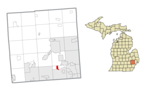
Bingham Farms, Michigan
Village in Michigan, United States
Distance: Approx. 626 meters
Latitude and longitude: 42.5175,-83.27777778
Bingham Farms is a village in Oakland County in the U.S. state of Michigan. A northern suburb of Detroit, Bingham Farms is located within Southfield Township, roughly 20 miles (32.2 km) northwest of downtown Detroit. As of the 2020 census, the village had a population of 1,124.
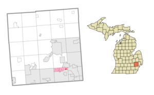
Franklin, Michigan
Village in Michigan, United States
Distance: Approx. 1865 meters
Latitude and longitude: 42.52,-83.30388889
Franklin is a village in Oakland County in the U.S. state of Michigan. A northern suburb of Detroit, Franklin is located within Southfield Township, roughly 20 miles (32.2 km) northwest of downtown Detroit. As of the 2020 census, the village had a population of 3,139.
Southfield Township, Michigan
Civil township in Michigan, United States
Distance: Approx. 2632 meters
Latitude and longitude: 42.52416667,-83.25444444
Southfield Township is a civil township in Oakland County in the U.S. state of Michigan. Today, the majority of the township consists of three suburban villages; Beverly Hills, Bingham Farms, and Franklin; though two small areas, comprising 0.17 square miles (0.44 km2), remain unincorporated. As of the 2020 census, the township's population was 14,886, including the villages; the unincorporated areas' population was 31.

Detroit Country Day School
Private, day, college preparatory school in Beverly Hills, Michigan, United States
Distance: Approx. 1521 meters
Latitude and longitude: 42.51422222,-83.2645
Detroit Country Day School (also known as DCD, DCDS, or Country Day) is a private, secular school located in three campuses in Oakland County, in the U.S. state of Michigan, north of Detroit. The administrative offices, facility services, safety and security services, and the upper school (Grades 9-12) are situated in a campus in Beverly Hills. The middle school (Grades 4-8) is also located in Beverly Hills, seamlessly connected to the upper school.
Farber Hebrew Day School – Yeshivat Akiva
Religious school in Michigan, United States
Distance: Approx. 2763 meters
Latitude and longitude: 42.50233333,-83.25286111
Yeshivat Akiva is an N-12 Modern Orthodox Religious Zionist day school in Southfield, Michigan, serving Southeast Michigan. It opened in 1964 as an elementary school and shortly thereafter added a middle school (in 1967) and high school (starting in 1971, with a 10th grade). From the start the school has had a strong connection to Israel and for the first two decades the school's 12th grade took place in Israel.

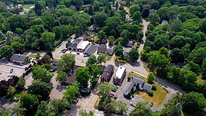
Franklin Cider Mill
Cider mill in Michigan
Distance: Approx. 2621 meters
Latitude and longitude: 42.53027778,-83.30527778
The Franklin Cider Mill, known previously as the Franklin Grist Mill, is a cider mill located in Franklin, Michigan. The family of former owner Jacob Peltz continues to operate the mill. The mill offers fresh apple cider, spice donuts, caramel apples, and apple pies and other products.
Southfield Christian School
Private christian school in Southfield, Michigan, United States
Distance: Approx. 2404 meters
Latitude and longitude: 42.49934,-83.26077
Southfield Christian School (SCS) is a private, college-preparatory Christian school in Southfield, Michigan. It is a ministry of Highland Park Baptist Church for grades PK–12.
Marian High School (Michigan)
Private, all-girls school in Bloomfield Hills, Michigan, United States
Distance: Approx. 2871 meters
Latitude and longitude: 42.53444444,-83.26277778
Marian High School is a private, Roman Catholic high school preparatory college for girls in Bloomfield Hills, Michigan in Metro Detroit.

Temple Beth El (Detroit)
Reform synagogue in Michigan, United States
Distance: Approx. 2060 meters
Latitude and longitude: 42.5317654,-83.2860994
Temple Beth El is a Reform synagogue located at in Bloomfield Township, Oakland County, Michigan, in the United States. Beth El was founded in 1850 in the city of Detroit, and is the oldest Jewish congregation in Michigan. Temple Beth El was a founding member of the Union for Reform Judaism (originally the Union of American Hebrew Congregations) in 1873, and hosted the meeting in 1889 during which the Central Conference of American Rabbis was established.
Park West Gallery
Commercial art gallery in Michigan, United States
Distance: Approx. 2860 meters
Latitude and longitude: 42.50378,-83.31532
Park West Gallery is a commercial art gallery based in Southfield, Michigan, United States. Park West Gallery claims to be the largest private art gallery in the world, but that is largely disputed, and that it has sold hundreds of works of art for thousands of dollars. It exhibits work from historic artists such as Renoir, Picasso, Rembrandt, and Durer as well as contemporary artists such as Peter Max, Michael Godard and Mark Kostabi.
Tel-Twelve Mall
Shopping mall in Michigan, United States
Distance: Approx. 1603 meters
Latitude and longitude: 42.499,-83.283
Tel-Twelve Mall is a shopping mall located in Southfield, Michigan, a suburb of Detroit, Michigan, United States. Developed as an enclosed mall in 1968, it was demolished and rebuilt in 2001 as a power center composed of big box tenants. Its anchor stores include Best Buy, DSW, Lowe's, Meijer, Michaels, Office Depot and PetSmart.
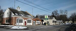
Franklin Historic District (Franklin, Michigan)
United States historic place
Distance: Approx. 2475 meters
Latitude and longitude: 42.52861111,-83.305
The Franklin Historic District is a primarily residential and commercial historic district located along Franklin Road and adjoining streets in the village of Franklin, Michigan in Oakland County. The district extends to Fourteen Mile Road on the north, Scenic Drive on the south, the Rouge River on the east, and several hundred feet from Franklin Road on the west. The district was listed on the National Register of Historic Places in 1969, and added to in 2005.
Weather in this IP's area
clear sky
8 Celsius
8 Celsius
6 Celsius
10 Celsius
1033 hPa
81 %
1033 hPa
1007 hPa
10000 meters
1.03 m/s
270 degree
07:51:14
18:44:26