67.201.87.7 - IP Lookup: Free IP Address Lookup, Postal Code Lookup, IP Location Lookup, IP ASN, Public IP
Country:
Region:
City:
Location:
Time Zone:
Postal Code:
ISP:
ASN:
language:
User-Agent:
Proxy IP:
Blacklist:
IP information under different IP Channel
ip-api
Country
Region
City
ASN
Time Zone
ISP
Blacklist
Proxy
Latitude
Longitude
Postal
Route
db-ip
Country
Region
City
ASN
Time Zone
ISP
Blacklist
Proxy
Latitude
Longitude
Postal
Route
IPinfo
Country
Region
City
ASN
Time Zone
ISP
Blacklist
Proxy
Latitude
Longitude
Postal
Route
IP2Location
67.201.87.7Country
Region
ohio
City
cincinnati
Time Zone
America/New_York
ISP
Language
User-Agent
Latitude
Longitude
Postal
ipdata
Country
Region
City
ASN
Time Zone
ISP
Blacklist
Proxy
Latitude
Longitude
Postal
Route
Popular places and events near this IP address

Norwood, Ohio
City in Ohio, United States
Distance: Approx. 277 meters
Latitude and longitude: 39.16,-84.455
Norwood is the third most populous city in Hamilton County, Ohio, United States, and an enclave of the larger city of Cincinnati. The population was 19,043 at the 2020 census. Originally settled as an early suburb of Cincinnati in the wooded countryside north of the city, the area is characterized by older homes and tree-lined streets.

Bond Hill, Cincinnati
Neighborhood of Cincinnati in Hamilton, Ohio, United States
Distance: Approx. 1673 meters
Latitude and longitude: 39.17472222,-84.46722222
Bond Hill is one of the 52 neighborhoods of Cincinnati, Ohio. Founded as a railroad suburb and temperance community in 1870 in northeastern Millcreek Township, it is one of a number of neighborhoods lining the Mill Creek. The population was 7,002 at the 2020 census.

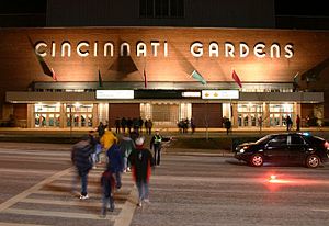
Cincinnati Gardens
Former indoor arena in Cincinnati, Ohio, US
Distance: Approx. 2132 meters
Latitude and longitude: 39.18111111,-84.45527778
Cincinnati Gardens was an indoor arena located in Cincinnati, Ohio, that opened in 1949. The 25,000 square foot (2,300 m2) brick and limestone building at 2250 Seymour Avenue in Bond Hill had an entrance that was decorated with six three-dimensional carved athletic figures. When it opened, its seating capacity of 11,000+ made it the seventh largest indoor arena in the United States.
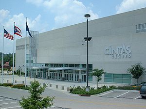
Cintas Center
Arena and conference center in Cincinnati
Distance: Approx. 1847 meters
Latitude and longitude: 39.150148,-84.471881
The Cintas Center is a 10,250-seat multi-purpose arena and conference center on the campus on Xavier University in Cincinnati, Ohio. The arena officially opened in 2000 and was constructed through private donations as part of Xavier University's Century Campaign. It is home to the Xavier University Musketeers basketball and volleyball teams.
Schmidt Fieldhouse
Building in Ohio, United States
Distance: Approx. 2304 meters
Latitude and longitude: 39.149666,-84.47834
Schmidt Fieldhouse, formerly known as Xavier University Fieldhouse, is an on-campus arena at Xavier University in Cincinnati, Ohio.
Norwood High School (Ohio)
Public, coeducational high school in Norwood, , Ohio, U.S.≈
Distance: Approx. 230 meters
Latitude and longitude: 39.16138889,-84.45944444
Norwood High School is a high school in Norwood, Ohio which has been rated Excellent by the Ohio Department of Education. It is the only high school in the Norwood City School District. The Drake Planetarium, located in the high school, is named after astronomer and astrophysicist Frank Drake and is linked to NASA. Norwood High School owns the 1936 state title for baseball.

Norwood Mound
Archaeological site in Ohio, United States
Distance: Approx. 1157 meters
Latitude and longitude: 39.167841,-84.445813
Norwood Mound, also known as “Indian Mound” by locals, is a prehistoric Native American earthwork mound located in Norwood, Ohio, United States, an enclave city of Cincinnati in Hamilton County, Ohio. It was listed on the National Register of Historic Places on May 2, 1974.

Norwood Municipal Building
Historic place in Ohio, United States
Distance: Approx. 78 meters
Latitude and longitude: 39.16166667,-84.45611111
The Norwood Municipal Building, also known as Norwood City Hall, is a historic government building at 4645 Montgomery Road in Norwood, Ohio. The building was constructed in 1914-16 on the site of Norwood's first city hall, which was built in 1881. Cincinnati-based architecture firm Weber, Werner & Adkins designed the building in the Second Renaissance Revival style.

Avon Woods Preserve
Distance: Approx. 1889 meters
Latitude and longitude: 39.162493,-84.478776
The Avon Woods Preserve, owned and operated by the Cincinnati Park Board, is a city park in the North Avondale neighborhood of Cincinnati, Ohio. The park has nature trails, gardens, a nature center and stream, as well as educational programs offered to children. Avon Woods is a nature preserve and is made up of rolling hills, hiking trails and a valley.

Paddock Hills, Cincinnati
Neighborhood of Cincinnati in Hamilton, Ohio, United States
Distance: Approx. 1646 meters
Latitude and longitude: 39.16666667,-84.475
Paddock Hills is one of the 52 neighborhoods of Cincinnati, Ohio. The population was 1,038 at the 2020 census. The neighborhood is noted for its stock of Dutch Colonial Revival architecture, Tudor Revival architecture and bungalow houses.
J. Page Hayden Field
Baseball venue in Cincinnati, Ohio
Distance: Approx. 2157 meters
Latitude and longitude: 39.150244,-84.47676
J. Page Hayden Field is a baseball venue in Cincinnati, Ohio, United States. It is home to the Xavier Musketeers baseball team of the NCAA Division I Big East. Since 2006, the Cincinnati Steam of the collegiate summer Great Lakes Summer Collegiate League have also used Hayden Field.

Avon Fields Golf Course
Golf course in Cincinnati, Ohio, US
Distance: Approx. 1804 meters
Latitude and longitude: 39.158144,-84.477197
Avon Fields Golf Course is a historic golf course in Cincinnati, Ohio, USA. The course was developed and run by the city until the late 1990s when Kemper Sports Management won the rights to run the city courses. In 2003, Billy Casper Golf took over the contract. Avon Field is located in North Avondale and borders Norwood.
Weather in this IP's area
clear sky
-17 Celsius
-22 Celsius
-18 Celsius
-16 Celsius
1038 hPa
63 %
1038 hPa
1008 hPa
10000 meters
2.24 m/s
2.68 m/s
336 degree
6 %


