67.201.10.146 - IP Lookup: Free IP Address Lookup, Postal Code Lookup, IP Location Lookup, IP ASN, Public IP
Country:
 USA
USARegion:
City:
Location:
Time Zone:
Postal Code:
ISP:
ASN:
language:
User-Agent:
Proxy IP:
Blacklist:
IP information under different IP Channel
ip-api
Country
Region
City
ASN
Time Zone
ISP
Blacklist
Proxy
Latitude
Longitude
Postal
Route
db-ip
Country
Region
City
ASN
Time Zone
ISP
Blacklist
Proxy
Latitude
Longitude
Postal
Route
IPinfo
Country
Region
City
ASN
Time Zone
ISP
Blacklist
Proxy
Latitude
Longitude
Postal
Route
IP2Location
67.201.10.146Country
usRegion
california
City
los angeles
Time Zone
America/Los_Angeles
ISP
Language
User-Agent
Latitude
Longitude
Postal
ipdata
Country
Region
City
ASN
Time Zone
ISP
Blacklist
Proxy
Latitude
Longitude
Postal
Route
Popular places and events near this IP address

Toy District, Los Angeles
Neighborhood in the United States
Distance: Approx. 319 meters
Latitude and longitude: 34.04625,-118.244565
The Toy District is a 12-block area in eastern Downtown Los Angeles, bounded by Los Angeles Street on the west, Third and Fifth streets on the north and south and San Pedro Street on the east. It is a multilingual, multicultural area that consists of one- and two-story buildings often painted in pastel shades and is home to roughly five hundred toy- and electronics-related businesses.
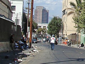
Skid Row, Los Angeles
Neighborhood in the US
Distance: Approx. 249 meters
Latitude and longitude: 34.044232,-118.243886
Skid Row is the unofficial name for a neighborhood in Downtown Los Angeles officially known as Central City East. Skid Row contains one of the largest stable populations of homeless people in the United States, estimated at over 4,400, and has been known for its condensed homeless population since at least the 1930s. Its long history of police raids, targeted city initiatives, and homelessness advocacy make it one of the most notable districts in Los Angeles.

Alan Hotel
Former hotel in Los Angeles
Distance: Approx. 438 meters
Latitude and longitude: 34.049,-118.242
The Alan Hotel was a hotel located in the Little Tokyo neighborhood in Downtown Los Angeles, California. The hotel was established in 1942, and was built directly across from the noted Civic Center Mall. Its address was 236 East Second Street.
Alameda Street
Road in Los Angeles County, California
Distance: Approx. 389 meters
Latitude and longitude: 34.04722222,-118.23805556
Alameda Street is a major north-south thoroughfare in Los Angeles County, California. It is approximately 21 miles in length, running from Harry Bridges Boulevard in Wilmington; and through Carson, Compton, Lynwood, Watts, Florence-Graham, Huntington Park, Vernon and Arts District to Spring and College in Chinatown. For much of its length, Alameda runs through present and former industrial corridors, and is paralleled by Union Pacific Railroad (formerly Southern Pacific Railroad) tracks.

National Japanese American Veterans Memorial Court
Memorial site in Los Angeles, California, United States
Distance: Approx. 298 meters
Latitude and longitude: 34.04777778,-118.24138889
The National Japanese American Veterans Memorial Court (Japanese: 日系米国人退役軍人慰霊碑, Nikkei Beikokujin Taiekigunjin Ireihi) is a national memorial court in Los Angeles, California, honoring the bravery and sacrifice of Japanese American service members lost in service to the United States. Of the approximately 12,000 names recognized, conflicts include the Spanish–American War, World War II, Korea, Vietnam, Grenada, Iraq, and Afghanistan. The memorial is maintained by and located adjacent to the Japanese American Cultural & Community Center (Japanese: 日米文化会館) in Little Tokyo.
Asahi Gakuen
Supplementary Japanese school in the United States
Distance: Approx. 389 meters
Latitude and longitude: 34.0477774,-118.2441152
Asahi Gakuen, or the Los Angeles Japanese School, is a part-time Japanese school in the Los Angeles metropolitan area. The school was founded by the Association for the Promotion of Japanese Language Education in Los Angeles. In 1988, the school had 2,500 students.
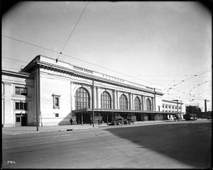
Central Station (Los Angeles)
Former Southern Pacific train stop
Distance: Approx. 362 meters
Latitude and longitude: 34.0423,-118.2394
Central Station was the Southern Pacific Railroad's main passenger terminal in Los Angeles, California. It was formerly on Central Avenue at Fifth Street, in eastern Downtown Los Angeles. The primary hub for Southern Pacific's passenger operations in Southern California, it was served by the Sunset Limited, Coast Daylight, Golden State, and other named trains.

Arcade Depot
Former Southern Pacific rail terminal, Los Angeles
Distance: Approx. 434 meters
Latitude and longitude: 34.0418,-118.2389
The Arcade Depot was the main Southern Pacific Railroad passenger railway station of Los Angeles, California between 1888 and 1914. It was located on Alameda Street, between 5th and 6th Streets. This station consolidated intercity services at a location closer to Downtown Los Angeles than the previous terminal, the San Fernando Street Depot.
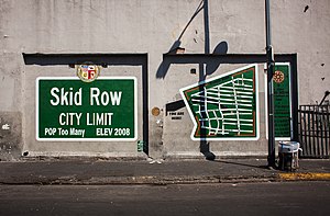
Skid Row City Limits Mural
Mural in Los Angeles
Distance: Approx. 453 meters
Latitude and longitude: 34.043277,-118.245787
The Skid Row City Limit Mural is a 18-by-50-foot (5.5 by 15.2 m) mural displayed on San Julian Street in Los Angeles, California. It features a map demarcating Skid Row's legally recognized boundaries alongside an official-looking sign, replete with city seal, reading "Skid Row City Limit, Population: Too Many." it was the initial installation of a mural project that eventually covered the whole wall on the San Julian block just north of 6th Street (Closest address is 570 S San Julian St). Installed in compliance with the city's mural ordinance, the project was created and organized by Skid Row community activist General Jeff Page for his Issues and Solutions organization, with mural installation led by local street art crew Winston Death Squad.

Catalina Swimwear Building
Building in Downtown Los Angeles, United States
Distance: Approx. 232 meters
Latitude and longitude: 34.04478,-118.24389
The Catalina Swimwear Building is a six-story, industrial building located in Downtown Los Angeles. The building was designed in 1923 by architect William Douglas Lee and is Lee's first major commission as an independent architect in Los Angeles. The façade has Neoclassical features and articulation that reflect early twentieth-century architecture, more formal than typical for a building intended for manufacturing purposes.

Union Rescue Mission
Homeless shelter in California
Distance: Approx. 380 meters
Latitude and longitude: 34.0433,-118.2449
The Union Rescue Mission, commonly abbreviated as the URM, is a Christian homeless shelter in the Skid Row neighborhood of Los Angeles, California. It is the oldest in the city and the largest private homeless shelter in the United States. The organization behind the URM is a 501(c)(3) nonprofit that was established in 1891.
715 (restaurant)
Japanese restaurant in Los Angeles, California, U.S.
Distance: Approx. 427 meters
Latitude and longitude: 34.0455,-118.2368
715, or 715 Sushi, is a Michelin-starred Japanese restaurant in the Arts District neighborhood of Los Angeles, California, United States.
Weather in this IP's area
mist
14 Celsius
14 Celsius
12 Celsius
18 Celsius
1017 hPa
85 %
1017 hPa
997 hPa
3219 meters
4.12 m/s
260 degree
100 %