67.199.133.75 - IP Lookup: Free IP Address Lookup, Postal Code Lookup, IP Location Lookup, IP ASN, Public IP
Country:
Region:
City:
Location:
Time Zone:
Postal Code:
ISP:
ASN:
language:
User-Agent:
Proxy IP:
Blacklist:
IP information under different IP Channel
ip-api
Country
Region
City
ASN
Time Zone
ISP
Blacklist
Proxy
Latitude
Longitude
Postal
Route
db-ip
Country
Region
City
ASN
Time Zone
ISP
Blacklist
Proxy
Latitude
Longitude
Postal
Route
IPinfo
Country
Region
City
ASN
Time Zone
ISP
Blacklist
Proxy
Latitude
Longitude
Postal
Route
IP2Location
67.199.133.75Country
Region
california
City
santa clarita
Time Zone
America/Los_Angeles
ISP
Language
User-Agent
Latitude
Longitude
Postal
ipdata
Country
Region
City
ASN
Time Zone
ISP
Blacklist
Proxy
Latitude
Longitude
Postal
Route
Popular places and events near this IP address

Santa Clarita Valley
Valley in Los Angeles County, California, United States
Distance: Approx. 2090 meters
Latitude and longitude: 34.42,-118.52
The Santa Clarita Valley (SCV) is part of the upper watershed of the Santa Clara River in Southern California. The western portion of the valley was part of the 48,612-acre (19,673 ha) Rancho San Francisco Mexican land grant. Located in Los Angeles County.

Soledad Canyon
Canyon in Los Angeles County, California, United States
Distance: Approx. 2087 meters
Latitude and longitude: 34.42416667,-118.54138889
Soledad Canyon is a long narrow canyon/valley located in Los Angeles County, California between the cities of Palmdale and Santa Clarita. It is a part of the Santa Clara River Valley, and extends from the top of Soledad Pass to the open plain of the valley in Santa Clarita. The upstream section of the Santa Clara River runs through it.
William S. Hart Union High School District
School district in California, United States
Distance: Approx. 2292 meters
Latitude and longitude: 34.4104,-118.5109
The William S. Hart Union High School District (commonly referred to simply as the Hart District) is a school district in the Santa Clarita Valley of Los Angeles County, California. It serves all of the valley's high school students (grades 9–12) and most of its junior high school students (grades 7–8). As of 2023–24, the total number of enrolled students (in 16 schools) was 22,135.
William S. Hart High School
Public high school in Santa Clarita, California, United States
Distance: Approx. 2415 meters
Latitude and longitude: 34.3845,-118.5378
William S. Hart High School is a four-year public high school in the neighborhood of Newhall in the city of Santa Clarita, California, United States. Founded in 1945, it is the oldest high school in the Santa Clarita Valley. Named for local cowboy actor William S. Hart, it is part of the William S. Hart Union High School District.
Newhall School District
School district in Santa Clarita, California
Distance: Approx. 2190 meters
Latitude and longitude: 34.3892,-118.5475
The Newhall School District is an elementary school district in the Santa Clarita Valley that serves the Valencia and Newhall communities within the city of Santa Clarita, California, as well as the Stevenson Ranch community in unincorporated Los Angeles County. It currently includes ten schools.

Santa Clarita, California
City in California, United States
Distance: Approx. 2090 meters
Latitude and longitude: 34.42,-118.52
Santa Clarita (; Spanish for "Little St. Clare") is a city in northwestern Los Angeles County in the U.S. state of California. With a 2020 census population of 228,673, it is the third-most populous city in Los Angeles County, the 17th-most populous in California, and the 103rd-most populous city in the United States.

Valencia Town Center
Shopping mall in Santa Clarita, California, United States
Distance: Approx. 2308 meters
Latitude and longitude: 34.415,-118.558
Valencia Town Center is a shopping mall in the neighborhood of Valencia in Santa Clarita, California. Centennial Realty has owned the mall since September 1, 2023. The previous owner, Westfield Group had acquired a quarter-interest in the property in 2002 and a further quarter-interest in 2005, thereafter assuming management control.

Santa Clarita station
Train station in Santa Clarita, California, US
Distance: Approx. 1243 meters
Latitude and longitude: 34.4135206,-118.5251842
Santa Clarita station is a Metrolink train station in the city of Santa Clarita, California. It is served by Metrolink's Antelope Valley Line between Los Angeles Union Station and Lancaster station. Because the City of Santa Clarita has three other Metrolink stations, this station is sometimes referred to as Soledad Metrolink.

Saugus Speedway
Former race track in Santa Clarita, California
Distance: Approx. 1333 meters
Latitude and longitude: 34.4164,-118.5279
Saugus Speedway is a 1/3 mile racetrack in Saugus, Santa Clarita, California on a 35-acre (140,000 m2) site. The track hosted one NASCAR Craftsman Truck Series event in 1995, which was won by Ken Schrader. Schrader became the first NASCAR driver to win in a race in all three of the sanctioning body's major series, following previous wins in the Winston Cup and Busch Grand National Series.
Takuyumam, California
Former Chumashan settlement in California, United States
Distance: Approx. 2415 meters
Latitude and longitude: 34.38472222,-118.53083333
Takuyumam is a former Chumashan settlement in Los Angeles County, California. Its former location is now the site of Newhall.

Henry Mayo Newhall Memorial Hospital
Hospital in Santa Clarita, California
Distance: Approx. 1898 meters
Latitude and longitude: 34.39777778,-118.55333333
Henry Mayo Newhall Hospital (commonly referred to as Henry Mayo Hospital) is a 357-bed not-for-profit community hospital and trauma center in Valencia, Santa Clarita, California. It was founded in 1975. Named after businessman Henry Mayo Newhall, the hospital recently opened a new patient tower that includes 90 private patient rooms and a new Center for Women and Newborns, also with all private rooms.

McBean Regional Transit Center
Transit center in Santa Clarita, California
Distance: Approx. 2605 meters
Latitude and longitude: 34.414,-118.562
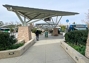
McBean Regional Transit Center, also known by its acronym MRTC, is a transit center and bus station located at 24375 Valencia Boulevard in the Valencia area of Santa Clarita, California, near the intersection of Valencia Boulevard and McBean Parkway. It is located next to the Westfield Valencia Town Center. The facility opened on January 20, 2002, with 12 bus stands.
Weather in this IP's area
light rain
12 Celsius
11 Celsius
11 Celsius
13 Celsius
1014 hPa
90 %
1014 hPa
955 hPa
2.68 m/s
5.81 m/s
110 degree
100 %