67.158.174.61 - IP Lookup: Free IP Address Lookup, Postal Code Lookup, IP Location Lookup, IP ASN, Public IP
Country:
Region:
City:
Location:
Time Zone:
Postal Code:
IP information under different IP Channel
ip-api
Country
Region
City
ASN
Time Zone
ISP
Blacklist
Proxy
Latitude
Longitude
Postal
Route
Luminati
Country
Region
me
City
brownfield
ASN
Time Zone
America/New_York
ISP
PIVOT
Latitude
Longitude
Postal
IPinfo
Country
Region
City
ASN
Time Zone
ISP
Blacklist
Proxy
Latitude
Longitude
Postal
Route
IP2Location
67.158.174.61Country
Region
maine
City
lewiston
Time Zone
America/New_York
ISP
Language
User-Agent
Latitude
Longitude
Postal
db-ip
Country
Region
City
ASN
Time Zone
ISP
Blacklist
Proxy
Latitude
Longitude
Postal
Route
ipdata
Country
Region
City
ASN
Time Zone
ISP
Blacklist
Proxy
Latitude
Longitude
Postal
Route
Popular places and events near this IP address

Lewiston, Maine
City in Maine, United States
Distance: Approx. 57 meters
Latitude and longitude: 44.10055556,-70.21527778
Lewiston (; French: [luistɔ̃]) is the second most populous city in the U.S. state of Maine, with the city's population at 37,121 as of the 2020 United States Census. The city lies halfway between Augusta, the state's capital, and Portland, the state's most populous city. A part of Androscoggin County, it is one-half of the Lewiston–Auburn metropolitan statistical area, commonly referred to as "L/A." or "L-A." Lewiston exerts a significant impact upon the diversity, religious variety, commerce, education, and economic power of Maine.
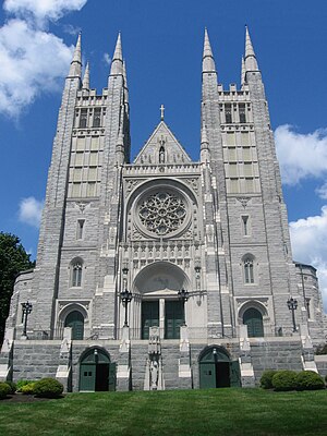
Basilica of Saints Peter and Paul (Lewiston, Maine)
Historic church in Maine, United States
Distance: Approx. 310 meters
Latitude and longitude: 44.09816,-70.212286
The Basilica of Saints Peter and Paul (French: Basilique Saint-Pierre et Saint-Paul) in Lewiston, Maine, also known as Ss. Peter and Paul Church, is a church which is a part of the Roman Catholic Diocese of Portland.

Healy Asylum
United States historic place
Distance: Approx. 362 meters
Latitude and longitude: 44.09722222,-70.21361111
The Healy Asylum is an historic building in Lewiston, Maine. It was built in 1893 as an orphanage for boys, a role it served until about 1970. It is now known as Healy Terrace, and is used for affordable senior housing.

Kora Temple
United States historic place
Distance: Approx. 17 meters
Latitude and longitude: 44.10027778,-70.21472222
The Kora Temple is a historic Masonic building at 11 Sabattus Street in Lewiston, Maine. The temple was built in 1908 by the Ancient Arabic Order, Nobles of the Mystic Shrine. The Shriners are a fraternal organization affiliated with Freemasonry and are known for their charitable works such as the Shriners Hospitals for Children which provide free medical care to children.

Holland–Drew House
Historic house in Maine, United States
Distance: Approx. 378 meters
Latitude and longitude: 44.10333333,-70.21222222
The Holland–Drew House is a historic house at 377 Main Street in Lewiston, Maine. Built in 1854, it is a high-quality local example of Italianate architecture executed in brick. It is also notable for some of its owners, who were prominent in the civic and business affairs of the city.

Lewiston Trust and Safe Deposit Company
United States historic place
Distance: Approx. 402 meters
Latitude and longitude: 44.09777778,-70.21805556
The Lewiston Trust and Safe Deposit Company is a historic commercial building at 46 Lisbon Street in Lewiston, Maine. Built in 1898, it is one of the least-altered designs of the important local architectural firm Coombs, Gibbs & Wilkinson. Its only significant alterations were in 1926 and the 1940s, when it served as a retail space occupied by Grant's Clothing for many years.

First National Bank (Lewiston, Maine)
United States historic place
Distance: Approx. 359 meters
Latitude and longitude: 44.09861111,-70.21833333
The First National Bank is a historic commercial building in Lewiston, Maine. Built about 1903 for the city's first chartered bank, it is a fine local example of French-inspired Classical Revival architecture. The building was listed on the National Register of Historic Places in 1986.

Dingley Building
United States historic place
Distance: Approx. 233 meters
Latitude and longitude: 44.09861111,-70.21611111
The Dingley Building, formerly the Oak Street School, is a historic municipal building at 36 Oak Street in Lewiston, Maine. Built in 1890, it is a distinctive local example of Richardsonian Romanesque architecture, designed by local architect George M. Coombs. It was added to the National Register of Historic Places in 1976.

St. Joseph's Catholic Church (Lewiston, Maine)
Historic church in Maine, United States
Distance: Approx. 129 meters
Latitude and longitude: 44.1,-70.21611111
St. Joseph's Catholic Church is a historic former church building at 257 Main Street in Lewiston, Maine. Built 1864–67, it was the first Roman Catholic church in the city, and is one of only two surviving buildings in the state designed by Patrick C. Keely.

Union Block (Lewiston, Maine)
United States historic place
Distance: Approx. 413 meters
Latitude and longitude: 44.09805556,-70.21861111
The Union Block is a historic commercial building at 21-29 Lisbon Street in downtown Lewiston, Maine. Built in 1870, it is a good local example of commercial Italianate architecture, built during a significant period of the city's growth. It was listed on the National Register of Historic Places in 1986.

Great Falls Balloon Festival
Distance: Approx. 22 meters
Latitude and longitude: 44.100283,-70.214824
The Great Falls Balloon Festival is a hot air balloon festival held in the twin cities of Lewiston and Auburn, Maine. It has been held annually each August since 1993, although it was only held virtually in 2020, due to the COVID-19 pandemic. The festival, which is held on the banks of the Androscoggin River attracts up to 100,000 spectators each year.

Central Maine Medical Center
Hospital in Maine, United States
Distance: Approx. 83 meters
Latitude and longitude: 44.101129,-70.214395
The Central Maine Medical Center is a hospital located at 300 Main Street in the city of Lewiston, Maine. It serves most of Androscoggin County, including Lewiston and Auburn, Maine and various small and medium-sized communities. It is designated as a trauma center.
Weather in this IP's area
clear sky
-8 Celsius
-15 Celsius
-10 Celsius
-7 Celsius
1001 hPa
57 %
1001 hPa
988 hPa
10000 meters
8.23 m/s
11.32 m/s
300 degree
