Country:
 USA
USARegion:
City:
Latitude and Longitude:
Time Zone:
Postal Code:
IP information under different IP Channel
ip-api
Country
Region
City
ASN
Time Zone
ISP
Blacklist
Proxy
Latitude
Longitude
Postal
Route
IPinfo
Country
Region
City
ASN
Time Zone
ISP
Blacklist
Proxy
Latitude
Longitude
Postal
Route
MaxMind
Country
Region
City
ASN
Time Zone
ISP
Blacklist
Proxy
Latitude
Longitude
Postal
Route
Luminati
Country
USRegion
mi
City
columbiaville
ASN
Time Zone
America/Detroit
ISP
AIR-ADVANTAGE-ASN
Latitude
Longitude
Postal
db-ip
Country
Region
City
ASN
Time Zone
ISP
Blacklist
Proxy
Latitude
Longitude
Postal
Route
ipdata
Country
Region
City
ASN
Time Zone
ISP
Blacklist
Proxy
Latitude
Longitude
Postal
Route
Popular places and events near this IP address
Barnes Lake-Millers Lake, Michigan
Unincorporated community & former census-designated place in Michigan, United States
Distance: Approx. 6465 meters
Latitude and longitude: 43.17944444,-83.31222222
Barnes Lake-Millers Lake was a census-designated place (CDP) in Lapeer County in the U.S. state of Michigan. The CDP was used for statistical purposes and had no legal status as a municipality. The population was 1,093 at the 2010 census.

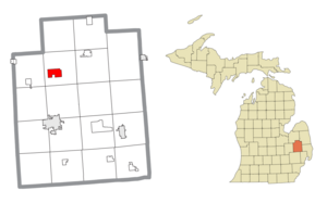
Columbiaville, Michigan
Village in Michigan, United States
Distance: Approx. 2396 meters
Latitude and longitude: 43.15694444,-83.40916667
Columbiaville is a village in Lapeer County in the U.S. state of Michigan. The population was 702 at the 2020 census. Located along the Flint River, the village is mostly within Marathon Township with a small portion extending south into Oregon Township.

Marathon Township, Michigan
Civil township in Michigan, United States
Distance: Approx. 5319 meters
Latitude and longitude: 43.19055556,-83.41638889
Marathon Township is a civil township of Lapeer County in the U.S. state of Michigan. The population was 4,467 at the 2020 Census.

Mayfield Township, Lapeer County, Michigan
Civil township in Michigan, United States
Distance: Approx. 9907 meters
Latitude and longitude: 43.09277778,-83.28805556
Mayfield Township is a civil township of Lapeer County in the U.S. state of Michigan. The population was 7,988 at the 2020 Census.

Oregon Township, Michigan
Civil township in Michigan, United States
Distance: Approx. 5320 meters
Latitude and longitude: 43.10722222,-83.40944444
Oregon Township is a civil township of Lapeer County in the U.S. state of Michigan. The population was 5,712 at the 2020 Census.

Deerfield Township, Lapeer County, Michigan
Civil township in Michigan, United States
Distance: Approx. 8056 meters
Latitude and longitude: 43.18444444,-83.29361111
Deerfield Township is a civil township of Lapeer County in the U.S. state of Michigan. The population was 5,764 at the 2020 Census. There are no municipalities within the township, but Barnes Lake-Millers Lake is a census-designated place for statistical purposes.

Otter Lake, Michigan
Village in Michigan, United States
Distance: Approx. 9395 meters
Latitude and longitude: 43.21333333,-83.45805556
Otter Lake is a village in the U.S. state of Michigan. The village is split between Marathon Township in Lapeer County to the east and Forest Township in Genesee County to the west. The population was 426 at the 2020 census.
WMPC
Radio station in Lapeer, Michigan
Distance: Approx. 9791 meters
Latitude and longitude: 43.07944444,-83.30972222
WMPC (1230 kHz) is a non-commercial AM radio station licensed to Lapeer, Michigan, and serving the northern suburbs of Detroit and the Flint area. It broadcasts a Christian talk and teaching radio format and is owned by the Calvary Bible Church of Lapeer. It first began broadcasting on December 6, 1926 (1926-12-06), and is the oldest continuously operating Christian radio station in the United States.
LakeVille Community Schools
School district in Michigan
Distance: Approx. 6880 meters
Latitude and longitude: 43.16891667,-83.46188889
LakeVille Community Schools is a public school district in northeastern Genesee County in the U.S. state of Michigan and is part of the Genesee Intermediate School District.
Columbiaville station
Former train station in Michigan, US
Distance: Approx. 2348 meters
Latitude and longitude: 43.15611111,-83.40888889
Columbiaville Station, currently known as the Columbiaville Rotary Club and Public Library, is a former train station located at 4643 First Street in the village of Columbiaville in Marathon Township in northwestern Lapeer County, Michigan. It was designated as a Michigan State Historic Site on October 23, 1979, and later listed on the National Register of Historic Places on April 5, 1984, as the Detroit–Bay City Railroad Company Columbiaville Depot. Built in 1893, the structure is a mix of Late Victorian, Queen Anne, and Richardsonian Romanesque style architecture.

Barnes Lake, Michigan
Census-designated place & unincorporated community in Michigan, United States
Distance: Approx. 7327 meters
Latitude and longitude: 43.17916667,-83.3
Barnes Lake is a census-designated place (CDP) in the northwest part of Deerfield Township, Lapeer County, Michigan, United States, surrounding a lake of the same name. It is bordered to the west by the CDP of Millers Lake. M-24 forms the border between the two CDPs; the state highway leads north 12 miles (19 km) to Mayville and south 9 miles (14 km) to Lapeer.

Millers Lake, Michigan
Census-designated place & unincorporated community in Michigan, United States
Distance: Approx. 5666 meters
Latitude and longitude: 43.17944444,-83.32388889
Millers Lake is a census-designated place (CDP) in the northwest part of Deerfield Township, Lapeer County, Michigan, United States, surrounding a lake of the same name. It is bordered to the east by the CDP of Barnes Lake. M-24 forms the border between the two CDPs; the state highway leads north 12 miles (19 km) to Mayville and south 9 miles (14 km) to Lapeer.
Weather in this IP's area
clear sky
25 Celsius
25 Celsius
24 Celsius
27 Celsius
1021 hPa
53 %
1021 hPa
993 hPa
10000 meters
3.45 m/s
6.76 m/s
152 degree
07:14:47
19:41:49