Country:
 Canada
Region:
City:
Latitude and Longitude:
Time Zone:
Postal Code:
IP information under different IP Channel
ip-api
Country
Region
City
ASN
Time Zone
ISP
Blacklist
Proxy
Latitude
Longitude
Postal
Route
IPinfo
Country
Region
City
ASN
Time Zone
ISP
Blacklist
Proxy
Latitude
Longitude
Postal
Route
MaxMind
Country
Region
City
ASN
Time Zone
ISP
Blacklist
Proxy
Latitude
Longitude
Postal
Route
Luminati
Country
CAASN
Time Zone
America/Toronto
ISP
PACIFICONLINE
Latitude
Longitude
Postal
db-ip
Country
Region
City
ASN
Time Zone
ISP
Blacklist
Proxy
Latitude
Longitude
Postal
Route
ipdata
Country
Region
City
ASN
Time Zone
ISP
Blacklist
Proxy
Latitude
Longitude
Postal
Route
Popular places and events near this IP address

Woodward's Building
Historic commercial building in Vancouver, British Columbia, Canada
Distance: Approx. 209 meters
Latitude and longitude: 49.28227778,-123.10736111
The Woodward's Building is a historic building in the Downtown Eastside of Vancouver, British Columbia, Canada. The original portion of the building was constructed in 1903 for the Woodward's Department Store when that area of Cordova Street was the heart of Vancouver's retail shopping district. At one time, this was the premier shopping destination in Vancouver.

Sun Tower
Commercial, offices in Vancouver, British Columbia
Distance: Approx. 248 meters
Latitude and longitude: 49.281,-123.1084
The Sun Tower is a 17 storey 82 m (269 ft) Beaux-Arts building at 128 West Pender Street in Vancouver, British Columbia. It was known for its faux-patina steel dome painted to imitate copper cladding. In early February 2021 a newly finished roof clad in real penny-coloured copper tiles was revealed.
Gastown riots
1971 riot in Vancouver, Canada
Distance: Approx. 245 meters
Latitude and longitude: 49.28333333,-123.10416667
The Gastown riot, known also in the plural as Gastown riots, also known as "The Battle of Maple Tree Square", occurred in Vancouver, British Columbia, Canada, on August 7, 1971. Following weeks of arrests by undercover drug squad members in Vancouver as part of a special police operation directed by City hall, police broke up a protest smoke-in in the Gastown neighbourhood. The smoke-in was organized by the Youth International Party (Vancouver Yippies) against the use of undercover agents and in favour of the legalization of marijuana.

Hotel Europe (Vancouver)
Former: Hotel, Current: Low-income residential in Vancouver, British Columbia
Distance: Approx. 264 meters
Latitude and longitude: 49.28339722,-123.10364722
Hotel Europe is a six-story heritage building located at 43 Powell Street (at Alexander) in the Gastown area of Vancouver, British Columbia. The building was commissioned by hotelier Angelo Calori and built in 1908-1909 by Parr and Fee Architects. Situated on a triangular lot, the building is designed in the flatiron style.
Insite
Safe drug injection facility in Vancouver, B.C., Canada
Distance: Approx. 283 meters
Latitude and longitude: 49.28111111,-123.10111111
Insite is a supervised drug injection site in the Downtown Eastside (DTES) neighbourhood of Vancouver, British Columbia, Canada The DTES had 4,700 chronic drug users in 2000 and has been considered to be the centre of an "injection drug epidemic". The site provides a supervised and health-focused location for injection drug use, primarily heroin. The clinic does not supply any drugs.

Sam Kee Building
Narrow commercial building in Vancouver, British Columbia
Distance: Approx. 89 meters
Latitude and longitude: 49.280425,-123.104706
The Sam Kee Building (Chinese: 三記號大樓), also known as the Jack Chow Building, is a two-storey commercial building in Vancouver, British Columbia, Canada, located near the entrance to the city's Chinatown. It is noted for its narrow depth, which varies by floor. The ground floor is 4 feet 11 inches (1.50 m) wide, while the upper floor spans 6 feet (1.8 m) because of its overhanging bay windows.

North Star Hotel
Defunct hotel in Vancouver, Canada
Distance: Approx. 64 meters
Latitude and longitude: 49.28177,-123.10494
The North Star hotel is a former hotel at the southern edge of Gastown in Vancouver, British Columbia, Canada. Located at 5 West Hastings Street, it is a four-story red brick Victorian Italianate construction completed at an unidentified date, between the 1890s and 1904.

Dr. Sun Yat-Sen Classical Chinese Garden
Chinese garden in Vancouver, British Columbia
Distance: Approx. 217 meters
Latitude and longitude: 49.279551,-123.103416
The Dr. Sun Yat-Sen Classical Chinese Garden (Chinese: 中山公園; lit. 'Zhongshan Park') is a Chinese garden in Vancouver, British Columbia, Canada.

Centre A
Public art gallery in Vancouver, British Columbia
Distance: Approx. 29 meters
Latitude and longitude: 49.28138889,-123.10472222
Centre A (Vancouver International Centre for Contemporary Asian Art) is a non-profit public art gallery in Vancouver committed to the research, production, presentation and interpretation of contemporary Asian art. It is the only public gallery in Canada dedicated to contemporary Asian and Asian Diasporic visual art practices. Founded in 1999 by Hank Bull (Founding Director), Zheng Shengtian and Stephanie Holmquist, the centre has been led by a board of directors with respected members of the community consisting Milton Wong, Joanne Louie Mah, Joe Wai and Anndraya Luui.

Chinese Canadian Military Museum Society
Museum in British Columbia, Canada
Distance: Approx. 240 meters
Latitude and longitude: 49.279762,-123.102534
The Chinese Canadian Military Museum Society (CCMMS) is located in Vancouver, on the second floor of the Chinese Cultural Centre. It was created in 1998 and maintains a museum in that city. The museum has given temporary displays to the Canadian War Museum in Ottawa.
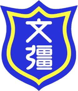
Mon Keang School
Chinese school in Vancouver, British Columbia
Distance: Approx. 270 meters
Latitude and longitude: 49.2806,-123.1014
Mon Keang School (Chinese: 文彊學校) is a Chinese school located inside the Wongs' Benevolent Association Building at 123A East Pender Street, in the Chinatown of Vancouver, British Columbia, Canada. Classes have historically been taught in Cantonese, the prestige variety of Yue Chinese.
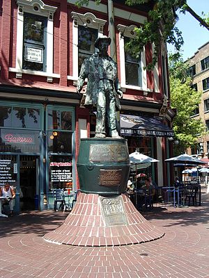
Statue of John Deighton
Statue previously in Vancouver, British Columbia, Canada
Distance: Approx. 242 meters
Latitude and longitude: 49.283322,-123.104257
A statue of John Deighton was commissioned in 1970, and was sculpted by Vern Simpson. Its location moved to various spots in Vancouver's Gastown neighborhood, in British Columbia, Canada. It was finally installed at a spot near where Deighton (also known as "Gassy Jack") had opened the Globe Saloon in 1867.
Weather in this IP's area
light rain
8 Celsius
4 Celsius
7 Celsius
9 Celsius
1020 hPa
89 %
1020 hPa
1020 hPa
9656 meters
9.39 m/s
12.07 m/s
45 degree
100 %
08:38:47
19:15:46