66.45.93.132 - IP Lookup: Free IP Address Lookup, Postal Code Lookup, IP Location Lookup, IP ASN, Public IP
Country:
Region:
City:
Location:
Time Zone:
Postal Code:
ISP:
ASN:
language:
User-Agent:
Proxy IP:
Blacklist:
IP information under different IP Channel
ip-api
Country
Region
City
ASN
Time Zone
ISP
Blacklist
Proxy
Latitude
Longitude
Postal
Route
db-ip
Country
Region
City
ASN
Time Zone
ISP
Blacklist
Proxy
Latitude
Longitude
Postal
Route
IPinfo
Country
Region
City
ASN
Time Zone
ISP
Blacklist
Proxy
Latitude
Longitude
Postal
Route
IP2Location
66.45.93.132Country
Region
pennsylvania
City
pittsburgh
Time Zone
America/New_York
ISP
Language
User-Agent
Latitude
Longitude
Postal
ipdata
Country
Region
City
ASN
Time Zone
ISP
Blacklist
Proxy
Latitude
Longitude
Postal
Route
Popular places and events near this IP address

Mt. Lebanon, Pennsylvania
Home rule municipality in Pennsylvania, United States
Distance: Approx. 2115 meters
Latitude and longitude: 40.375,-80.05
Mt. Lebanon (locally ) is a township with home rule status in Allegheny County, Pennsylvania, United States. The population was 34,075 at the 2020 census.

South Hills Village
Shopping mall near Pittsburgh, Pennsylvania, U.S.
Distance: Approx. 1637 meters
Latitude and longitude: 40.34345278,-80.05475278
South Hills Village is a two-level shopping mall that is located in the Pittsburgh suburbs of Bethel Park and Upper St. Clair Township, Pennsylvania, United States. The mall's anchor stores are Macy's, Von Maur, Target, Dick's Sporting Goods, and Barnes & Noble.

Mt. Lebanon School District
School district in Pennsylvania
Distance: Approx. 2082 meters
Latitude and longitude: 40.375,-80.051
The Mt. Lebanon School District is an American public school system that is located in Allegheny County. It serves residents of Mt.

Mt. Lebanon High School
Public high school in the United States
Distance: Approx. 2171 meters
Latitude and longitude: 40.3759027,-80.0511651
Mt. Lebanon High School is a four-year, comprehensive high school located in Pittsburgh, Pennsylvania, with an enrollment of 1,780 students in grades 9–12 for the 2024–2025 school year. Its mascot is the Blue Devil.

South Hills Village station
Light rail station in Pittsburgh, United States
Distance: Approx. 2129 meters
Latitude and longitude: 40.3393,-80.0527
South Hills Village is a station on Pittsburgh Regional Transit's light rail network. It is the southern terminus of both the Red and Blue lines. Port Authority's switching yard and shops are located just west of the station.

First Church of Christ, Scientist (Mt. Lebanon, Pennsylvania)
Distance: Approx. 1601 meters
Latitude and longitude: 40.3697,-80.0498
First Church of Christ, Scientist, built in 1939, was an historic redbrick Colonial Revival style Christian Science church located at 1100 Washington Road in Mt. Lebanon, Pennsylvania. Its entrance portico was supported by 6 Corinthian columns on the front and 4 on the rear.

Dorchester station (Pittsburgh Regional Transit)
Distance: Approx. 2125 meters
Latitude and longitude: 40.3408,-80.0481
Dorchester is a station on the Port Authority of Allegheny County's light rail network, located in Bethel Park, Pennsylvania. The street level stop was added to the route to serve the nearby Dorchester Apartment complex, for which the stop was named. A variety of apartment blocks have been located near the stop, as part of a transit village model designed to encourage public transit as the primary form of transportation for residents.

Bethel Village station
Distance: Approx. 1877 meters
Latitude and longitude: 40.3443,-80.0464
Bethel Village is a station on Pittsburgh Regional Transit's light rail, located in Bethel Park, Pennsylvania. A street-level stop, the station is designed to serve area residents that can walk to the station as well as shoppers who want to access the variety of big box stores located near the station and just to the north of the South Hills Village mall. The stop featured a turnaround loop for PCC's operating on the 47D Drake service, and was intended for cars operating on shuttle services that terminated at Dorchester.

Santa Barbara station (PAAC)
Distance: Approx. 1916 meters
Latitude and longitude: 40.3473,-80.0419
Santa Barbara was a station on the Port Authority of Allegheny County's light rail network, located in Bethel Park, Pennsylvania. The street level stop was designed as a small commuter stop, serving area residents who walked to the train so they could be taken toward Downtown Pittsburgh. Both directional stops were only accessible via walkways near the intersection of Milford Drive and Wyncote Road and beyond the dead end of South Conestoga Drive.

Highland station (Pittsburgh Regional Transit)
Distance: Approx. 1989 meters
Latitude and longitude: 40.3484,-80.0399
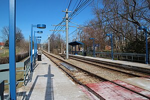
Highland is a station on the Port Authority of Allegheny County's light rail network, located in Bethel Park, Pennsylvania. Located in a railroad cut, the stop is designed as a small commuter stop, serving area residents who walk to the train so they can be taken toward Downtown Pittsburgh. A staircase to each platform is available from Highland Road, which crosses over the line on an overpass.

Casswell station
Rail station in Bethel Park, Pennsylvania, US
Distance: Approx. 2406 meters
Latitude and longitude: 40.34916667,-80.03388889
Casswell is a station on Pittsburgh Regional Transit's light rail network, located in Bethel Park, Pennsylvania. The street level stop is designed as a small commuter stop, serving area residents who walk to the train so they can be taken toward Downtown Pittsburgh. In May 2024, the Federal Transit Administration awarded The T $8 million to construct accessible platforms at ten Red Line stops, including Casswell.

Gilfillan Farm
United States historic place
Distance: Approx. 1769 meters
Latitude and longitude: 40.342,-80.064
Gilfillan Farm is located at the junction of Washington (U.S. Route 19) and Orr roads in Upper St. Clair Township, Allegheny County, Pennsylvania, United States. It is a working farm whose current form dates to the mid-19th century.
Weather in this IP's area
few clouds
-11 Celsius
-17 Celsius
-12 Celsius
-10 Celsius
1032 hPa
53 %
1032 hPa
988 hPa
10000 meters
3.6 m/s
150 degree
20 %