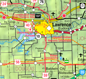
Country:
Region:
City:
Latitude and Longitude:
Time Zone:
Postal Code:
IP information under different IP Channel
ip-api
Country
Region
City
ASN
Time Zone
ISP
Blacklist
Proxy
Latitude
Longitude
Postal
Route
Luminati
Country
Region
ks
City
lawrence
ASN
Time Zone
America/Chicago
ISP
MIDCONTINENT-COMMUNICATIONS
Latitude
Longitude
Postal
IPinfo
Country
Region
City
ASN
Time Zone
ISP
Blacklist
Proxy
Latitude
Longitude
Postal
Route
db-ip
Country
Region
City
ASN
Time Zone
ISP
Blacklist
Proxy
Latitude
Longitude
Postal
Route
ipdata
Country
Region
City
ASN
Time Zone
ISP
Blacklist
Proxy
Latitude
Longitude
Postal
Route
Popular places and events near this IP address
Veritas Christian School
Private school in Lawrence, Kansas, United States
Distance: Approx. 7219 meters
Latitude and longitude: 38.9875,-95.25083333
Veritas Christian School is a private, classical Christian school located in Lawrence, Kansas, United States. It is non-denominational and is supported by the tuition and donations from students and alumni. Veritas is a member of the Association of Classical and Christian Schools (ACCS) and a member of the Association of Christian Schools International (ACSI).

Lawrence station (Kansas)
Railway station in Lawrence, Kansas, US
Distance: Approx. 7809 meters
Latitude and longitude: 38.9712,-95.2305
Lawrence station is a train station in Lawrence, Kansas, United States, served by Amtrak's Southwest Chief train. Built in 1956 to replace an older station, it was added to the National Register of Historic Places in 2018 as Santa Fe Depot.

U.S. 40 and 59 Bridges
Bridge that crosses the Kansas river in Lawrence Kansas
Distance: Approx. 7501 meters
Latitude and longitude: 38.9762,-95.2357
The U.S. 40 and 59 Bridges are twin multi-beam girder bridges over the Kansas River at Lawrence, Kansas. The west bridge carries two lanes of southbound traffic, connecting to Vermont Street, while the east bridge carries two lanes of northbound traffic from Massachusetts Street. Both bridges converge on the north end to become North 2nd Street.
Kansas Turnpike Bridges
Bridge in Lawrence, Kansas
Distance: Approx. 6192 meters
Latitude and longitude: 38.992,-95.2393
The Kansas Turnpike Bridges are a pair of multi-beam girder bridge that carry the Kansas Turnpike and Interstate 70 over the Kansas River at Lawrence, Kansas. The first bridges were a pair of deck trusses, each carrying two lanes of traffic. The bridges were the site of the groundbreaking of the Turnpike on December 31, 1954.
Grant Township, Douglas County, Kansas
Township in Kansas, United States
Distance: Approx. 3661 meters
Latitude and longitude: 39.02222222,-95.23361111
Grant Township is a township in Douglas County, Kansas, USA. As of the 2000 census, its population was 442.

Sarcoxie Township, Jefferson County, Kansas
Township in Kansas, United States
Distance: Approx. 7480 meters
Latitude and longitude: 39.09583333,-95.23361111
Sarcoxie Township is a township in Jefferson County, Kansas, USA. As of the 2000 census, its population was 958.

Midland, Kansas
Unincorporated community in Kansas, United States
Distance: Approx. 4165 meters
Latitude and longitude: 39.02833333,-95.24222222
Midland is an unincorporated community in Douglas County, Kansas, United States. It is located two miles north of the city of Lawrence.
S. T. Zimmerman House
Historic house in Kansas, United States
Distance: Approx. 7054 meters
Latitude and longitude: 38.97888889,-95.23111111
The S. T. Zimmerman House is a historic house in Lawrence, Kansas. It was built c. 1870 in Lawrence, Kansas by mill owner S. T. Zimmerman. The Second Empire house is unique in the area for its style.
Buck Creek, Kansas
Unincorporated community in Kansas, U.S.
Distance: Approx. 7707 meters
Latitude and longitude: 39.05,-95.28222222
Buck Creek is an unincorporated community in Jefferson County, Kansas, United States.
Reno, Kansas
Unincorporated community in Kansas, U.S.
Distance: Approx. 6707 meters
Latitude and longitude: 39.05111111,-95.12
Reno is an unincorporated community in Leavenworth County, Kansas, United States. Reno is located at 39°03′04″N 95°07′12″W. It is part of the Kansas City metropolitan area.
Rim Rock Farm
Distance: Approx. 7567 meters
Latitude and longitude: 39.0788,-95.2627
Rim Rock Farm is an American historic cross country running course. The cross country course is renowned for its two covered bridges as part of the course. The course is located at 2276 Burnett Lane, Lawrence, Kansas.

Bowersock Dam
Hydroelectric dam in Lawrence, Kansas
Distance: Approx. 7574 meters
Latitude and longitude: 38.9753,-95.2353
The Bowersock Dam is a run-of-river dam on the Kansas River in Lawrence, Kansas. Constructed in 1874 to provide mechanical power, it now hosts the only hydroelectric plant in the state of Kansas. The dam, which is 655 feet long and approximately 17.08 feet tall, supplies water to two hydroelectric powerhouses, which have a combined installed capacity of seven megawatts.
Weather in this IP's area
clear sky
12 Celsius
11 Celsius
11 Celsius
13 Celsius
1015 hPa
47 %
1015 hPa
978 hPa
10000 meters
4.72 m/s
13.55 m/s
140 degree
07:04:29
17:06:43

