66.43.57.26 - IP Lookup: Free IP Address Lookup, Postal Code Lookup, IP Location Lookup, IP ASN, Public IP
Country:
 Canada
Region:
City:
Location:
Time Zone:
Postal Code:
ISP:
ASN:
language:
User-Agent:
Proxy IP:
Blacklist:
IP information under different IP Channel
ip-api
Country
Region
City
ASN
Time Zone
ISP
Blacklist
Proxy
Latitude
Longitude
Postal
Route
db-ip
Country
Region
City
ASN
Time Zone
ISP
Blacklist
Proxy
Latitude
Longitude
Postal
Route
IPinfo
Country
Region
City
ASN
Time Zone
ISP
Blacklist
Proxy
Latitude
Longitude
Postal
Route
IP2Location
66.43.57.26Country
caRegion
quebec
City
sainte-julie
Time Zone
America/Montreal
ISP
Language
User-Agent
Latitude
Longitude
Postal
ipdata
Country
Region
City
ASN
Time Zone
ISP
Blacklist
Proxy
Latitude
Longitude
Postal
Route
Popular places and events near this IP address
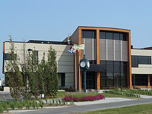
Sainte-Julie, Quebec
City in Quebec, Canada
Distance: Approx. 251 meters
Latitude and longitude: 45.58333333,-73.33333333
Sainte-Julie (French pronunciation: [sɛ̃t ʒyli]; originally Sainte-Julie-de-Verchères), is an off-island suburb of Montreal, in southwestern Quebec, Canada, east of Montreal in Marguerite-D'Youville Regional County Municipality. The population as of the Canada 2021 Census was 30,045. In 2009 Sainte-Julie was called one of the best towns in which to live in Quebec, and the city is often known as "The Happiest City in Quebec" (French: "La ville la plus heureuse du Québec").

Saint-Bruno-de-Montarville
City in Quebec, Canada
Distance: Approx. 5617 meters
Latitude and longitude: 45.53333333,-73.35
Saint-Bruno-de-Montarville (French pronunciation: [sɛ̃ bʁyno də mɔ̃taʁvil]) is an off-island suburb of Montreal, in southwestern Quebec, Canada, on the south bank of the Saint Lawrence River just east of Montreal. It lies on the west flank of Mont Saint-Bruno, one of the Monteregian Hills. The population as of the Canada 2021 Census was 26,273.
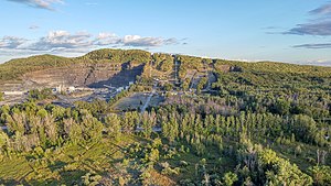
Mont Saint-Bruno
Mountain in Montérégie, Quebec, Canada
Distance: Approx. 3723 meters
Latitude and longitude: 45.555094,-73.309944
Mont Saint-Bruno (French pronunciation: [mɔ̃ sɛ̃ bʁyno]) is part of the Monteregian Hills in southern Quebec, Canada. Its summit stands 218 m (715 ft) high and lies 23 km (14 mi) east of downtown Montreal. This mountain has a ski resort, a natural area, and an apple orchard.

Marguerite-D'Youville
Provincial electoral district in Quebec, Canada
Distance: Approx. 5832 meters
Latitude and longitude: 45.588,-73.411
Marguerite-D'Youville is a former provincial electoral district in the Montérégie region of Quebec, Canada that elected members to the National Assembly of Quebec. As of its final election, it consisted of the cities of Boucherville and Sainte-Julie. It was created for the 1994 election from Bertrand and named after Saint Marie-Marguerite d'Youville, founder of the Order of Sisters of Charity of the Hôpital Général of Montreal.
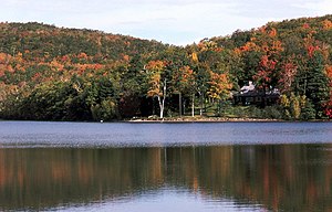
Mont-Saint-Bruno National Park
National park of Quebec, Canada
Distance: Approx. 3975 meters
Latitude and longitude: 45.55,-73.31666667
Mont-Saint-Bruno Provincial Park (French: Parc Provincial du Mont-Saint-Bruno, pronounced [paʁk pʁɔvɛ̃sjal dy mɔ̃ sɛ̃ bʁyno]) is a small national park of Quebec located near the municipality of Saint-Bruno-de-Montarville, 15 kilometres (9.3 mi) to the east of Montréal on the south shore of the Saint Lawrence River. The park, with an area of 8.84 square kilometres (3.41 sq mi), notably includes Mont Saint-Bruno, one of the Monteregian Hills which peaks at 218 metres (715 ft). The mountain is shared with the Ski Mont Saint-Bruno ski resort, a quarry and a small Canadian Forces (5th GSS) training camp.
Ski Mont Saint-Bruno
Distance: Approx. 2900 meters
Latitude and longitude: 45.55694444,-73.33333333
Ski Mont Saint-Bruno is a Canadian alpine ski facility. It is located on the slopes of Mont Saint-Bruno, in the city of Saint-Bruno-de-Montarville, Quebec. It is located right next to Parc national du Mont-Saint-Bruno, a Quebec provincial park that offers cross-country skiing and snowshoeing.
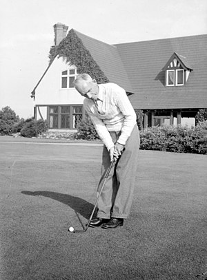
Mount Bruno Country Club
Distance: Approx. 6155 meters
Latitude and longitude: 45.5299,-73.314
Mount Bruno Golf Club is a private club located in Saint-Bruno-de-Montarville, Quebec, Canada. It is reputed to be one of the most exclusive golf clubs in Canada, and it has hosted the Canadian Open twice: in 1922, when it was won by Al Watrous, and in 1924, won by Leo Diegel. The course was originally designed by Willie Park Jr., later renovated by Stanley Thompson and Tom McBroom.
Institut de recherche d'Hydro-Québec
Distance: Approx. 5127 meters
Latitude and longitude: 45.6151779,-73.3834469
L'Institut de recherche d'Hydro-Québec (Hydro-Québec Research Institute), known by its acronym IREQ ("Institut de recherche en électricité du Québec", Quebec Electricity Research Institute) is a research institute established in 1967 by government-owned utility Hydro-Québec. IREQ operates from Varennes, a town on the south shore of Montreal, Quebec, Canada. IREQ operates on an annual research budget of approximately $100 million and specializes in the areas of high voltage, mechanics and thermomechanics, network simulations and calibration.
1979 Peter Jackson Classic
Distance: Approx. 4362 meters
Latitude and longitude: 45.5969,-73.2842
The 1979 Peter Jackson Classic was contested from July 26–29 at Richelieu Valley Golf Club. It was the 7th edition of the Peter Jackson Classic, and the first edition as a major championship on the LPGA Tour. This event was won by Amy Alcott.

Montarville (provincial electoral district)
Provincial electoral district in Quebec, Canada
Distance: Approx. 5523 meters
Latitude and longitude: 45.53333333,-73.33333333
Montarville (French pronunciation: [mɔ̃taʁvil]) is a provincial electoral district in the Montérégie region of Quebec, Canada that elects members to the National Assembly of Quebec. It consists of the municipalities of Boucherville and Saint-Bruno-de-Montarville, both of which are part of the urban agglomeration of Longueuil. It was created for the 2012 election from parts of the Marguerite-D'Youville and Chambly electoral districts.

Montarville
Federal electoral district in Quebec, Canada
Distance: Approx. 1325 meters
Latitude and longitude: 45.59166667,-73.325
Montarville (French pronunciation: [mɔ̃taʁvil]) is a federal electoral district in the Montérégie region of Quebec, Canada, that has been represented in the House of Commons of Canada since 2015. Montarville was created by the 2012 federal electoral boundaries redistribution and was legally defined in the 2013 representation order. It came into effect upon the call of the 42nd Canadian federal election, scheduled for 19 October 2015.
La Vallée du Richelieu Golf Club
Distance: Approx. 4362 meters
Latitude and longitude: 45.5969,-73.2842
La Vallée du Richelieu Golf Club is a private golf club in Sainte-Julie, Quebec, Canada. There are two 18-hole golf courses at the golf club, Le Rouville and Le Verchères.
Weather in this IP's area
scattered clouds
-4 Celsius
-11 Celsius
-5 Celsius
-4 Celsius
1012 hPa
64 %
1012 hPa
1008 hPa
10000 meters
11.83 m/s
18.52 m/s
270 degree
40 %