Country:
 USA
USARegion:
City:
Latitude and Longitude:
Time Zone:
Postal Code:
IP information under different IP Channel
ip-api
Country
Region
City
ASN
Time Zone
ISP
Blacklist
Proxy
Latitude
Longitude
Postal
Route
IPinfo
Country
Region
City
ASN
Time Zone
ISP
Blacklist
Proxy
Latitude
Longitude
Postal
Route
MaxMind
Country
Region
City
ASN
Time Zone
ISP
Blacklist
Proxy
Latitude
Longitude
Postal
Route
Luminati
Country
USRegion
ky
City
columbia
ASN
Time Zone
America/Chicago
ISP
BLUENET
Latitude
Longitude
Postal
db-ip
Country
Region
City
ASN
Time Zone
ISP
Blacklist
Proxy
Latitude
Longitude
Postal
Route
ipdata
Country
Region
City
ASN
Time Zone
ISP
Blacklist
Proxy
Latitude
Longitude
Postal
Route
Popular places and events near this IP address
Adair County, Kentucky
County in Kentucky, United States
Distance: Approx. 1023 meters
Latitude and longitude: 37.11,-85.28
Adair County is a county located in the U.S. state of Kentucky. As of the 2020 census, the population was 18,903. Its county seat and only municipality is Columbia.
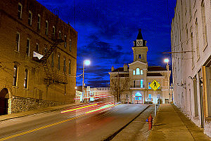
Columbia, Kentucky
City in Kentucky, United States
Distance: Approx. 3557 meters
Latitude and longitude: 37.10055556,-85.30611111
Columbia is a home rule-class city just above Russell Creek in Adair County, Kentucky, United States. The population was 4,452 at the 2010 census. Columbia is the seat of its county.
Lindsey Wilson College
United Methodist college in Columbia, Kentucky, US
Distance: Approx. 3079 meters
Latitude and longitude: 37.1028,-85.3015
Lindsey Wilson College is a private, United Methodist-related college in Columbia, Kentucky. Founded in 1903 as a training school, the college now offers in-person and online degree programs, offered at the associate, bachelor's, master's, and doctoral levels.
Adair County High School (Kentucky)
Public school in Columbia, Kentucky, United States
Distance: Approx. 4999 meters
Latitude and longitude: 37.10388889,-85.325
Adair County High School is a United States high school (grades 9 to 12) in the small town of Columbia, Adair County, Kentucky. It is the only high school of the county.
Garlin, Kentucky
Unincorporated community in Kentucky, United States
Distance: Approx. 1629 meters
Latitude and longitude: 37.11388889,-85.25222222
Garlin is an unincorporated community in Adair County, Kentucky, United States. Its elevation is 892 feet (272 m).
Burton Ridge
Distance: Approx. 2387 meters
Latitude and longitude: 37.122,-85.245
Burton Ridge is an area located in the eastern region of Adair County, Kentucky. Burton Ridge includes the communities of Beulah Chapel, Vester, Christine, Purdy, and Ella. Burton Ridge has a very strong, rich, and colorful history.
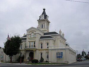
Adair County Courthouse (Kentucky)
United States historic place
Distance: Approx. 3451 meters
Latitude and longitude: 37.10277778,-85.30611111
The Adair County Courthouse in Columbia, Kentucky, a courthouse at 500 Public Sq., was built in 1885. It was listed on the National Register of Historic Places in 1974. It was designed by McDonald Brothers.

John Field House
United States historic place
Distance: Approx. 3515 meters
Latitude and longitude: 37.10138889,-85.30611111
The John Field House, at 111 E. Fortune St. in Columbia, Kentucky, was built in 1812. It was listed on the National Register of Historic Places in 1978.

Columbia Commercial Historic District (Columbia, Kentucky)
Historic district in Kentucky, United States
Distance: Approx. 3438 meters
Latitude and longitude: 37.10305556,-85.30611111
The Columbia Commercial Historic District in Columbia, Kentucky, was listed on the National Register of Historic Places in 2017. It is a 5.3 acres (2.1 ha) historic district with 29 contributing buildings, two non-contributing buildings, and a non-contributing site.

Dr. Nathan Gaither House
United States historic place
Distance: Approx. 3530 meters
Latitude and longitude: 37.10416667,-85.30777778
The Dr. Nathan Gaither House, at 100 S. High St. in Columbia, Kentucky was listed on the National Register of Historic Places in 1979.

Daniel Trabue House
United States historic place
Distance: Approx. 3318 meters
Latitude and longitude: 37.10055556,-85.30305556
The Daniel Trabue House, at 299 Jamestown St. in Columbia, Kentucky, was built in 1823. It was listed on the National Register of Historic Places in 1974.
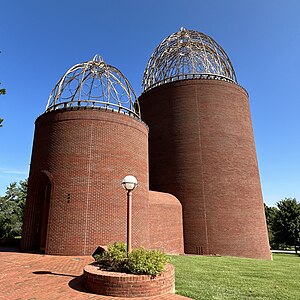
John B. Begley Chapel
Church in the United States
Distance: Approx. 2962 meters
Latitude and longitude: 37.10277778,-85.3
John B. Begley Chapel is a chapel located on the campus of Lindsey Wilson College in Columbia, Kentucky designed by architect E. Fay Jones, completed in 1997. Jones' design was inspired by agricultural forms common to the surrounding area.
Weather in this IP's area
clear sky
29 Celsius
28 Celsius
28 Celsius
29 Celsius
1016 hPa
27 %
1016 hPa
988 hPa
10000 meters
4.47 m/s
5.17 m/s
55 degree
5 %
06:24:27
18:47:15