66.255.224.11 - IP Lookup: Free IP Address Lookup, Postal Code Lookup, IP Location Lookup, IP ASN, Public IP
Country:
 USA
USARegion:
City:
Location:
Time Zone:
Postal Code:
ISP:
ASN:
language:
User-Agent:
Proxy IP:
Blacklist:
IP information under different IP Channel
ip-api
Country
Region
City
ASN
Time Zone
ISP
Blacklist
Proxy
Latitude
Longitude
Postal
Route
db-ip
Country
Region
City
ASN
Time Zone
ISP
Blacklist
Proxy
Latitude
Longitude
Postal
Route
IPinfo
Country
Region
City
ASN
Time Zone
ISP
Blacklist
Proxy
Latitude
Longitude
Postal
Route
IP2Location
66.255.224.11Country
usRegion
california
City
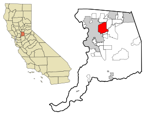
sacramento
Time Zone
America/Los_Angeles
ISP
Language
User-Agent
Latitude
Longitude
Postal
ipdata
Country
Region
City
ASN
Time Zone
ISP
Blacklist
Proxy
Latitude
Longitude
Postal
Route
Popular places and events near this IP address
Arden-Arcade, California
Census-designated place in California, United States
Distance: Approx. 2148 meters
Latitude and longitude: 38.60527778,-121.37972222
Arden-Arcade is a census-designated place (CDP) in Sacramento County, California, United States. The population was 94,659 at the 2020 census, making it the second most populous census-designated place in California. It is east of the city of Sacramento and west of the community of Carmichael.

La Riviera, California
Census-designated place in California, United States
Distance: Approx. 2795 meters
Latitude and longitude: 38.56666667,-121.35666667
La Riviera is a census-designated place (CDP) in Sacramento County, California, United States. It is part of the Sacramento–Arden-Arcade–Roseville Metropolitan Statistical Area. The population was 10,802 at the 2010 census, up from 10,273 at the 2000 census.

Jesuit High School (Carmichael)
Private high school in Carmichael, California, United States
Distance: Approx. 2254 meters
Latitude and longitude: 38.58666667,-121.35111111
Jesuit High School is a private Catholic college-preparatory high school run by the USA West Province of the Society of Jesus in the Sacramento suburb of Carmichael, California. It was founded in 1963 and enrolls about 1,000 young men from throughout greater Sacramento Valley in California. Jesuit is accredited by the Western Association of Schools and Colleges and the Western Catholic Educational Association (WCEA).

Rio Americano High School
Public high school in Sacramento, California
Distance: Approx. 1978 meters
Latitude and longitude: 38.57787,-121.35686
Rio Americano High School, colloquially known as Rio, is a public high school in Arden-Arcade, California, just outside Sacramento, serving students in grades 9 through 12 as part of the San Juan Unified School District. Rio Americano students come from the surrounding areas of Arden Park, Arden Oaks, Sierra Oaks, Fair Oaks, Carmichael, Gold River, and to a much lesser extent, the La Sierra community. In recent years, more students have been transferring from other districts and areas, partly due to the shift of Sacramento High School to a charter school.
KYDS
Radio station in Sacramento, California
Distance: Approx. 2864 meters
Latitude and longitude: 38.609,-121.362
KYDS is a Sacramento, California FM radio station with the frequency 91.5 MHz. It is maintained at El Camino Fundamental High School, and select students from the school are allowed to participate in its operation. The original inception of KYDS was in 1976, when it broadcast only in the school cafeteria during lunch hour.
El Camino Fundamental High School
High school in Arden-Arcade, Sacramento County, California, United States
Distance: Approx. 2923 meters
Latitude and longitude: 38.60953,-121.36184
El Camino Fundamental High School is a public high school in Arden-Arcade, California, near Sacramento. It is part of the San Juan Unified School District. Built in 1951 as El Camino High School, "Fundamental" was added to the name in the late 1970s to signify the school's intention to focus upon basic (fundamental) characteristics of successful schools, in particular a return to a strong disciplinary emphasis, a stripped-down college preparatory curriculum, and a contract-supported, enroll-through-application-only process.

Butterfield station
Tram stop in La Riviera, California, United States
Distance: Approx. 3374 meters
Latitude and longitude: 38.56722222,-121.34666667
Butterfield station is a side platformed SacRT light rail station in La Riviera, California, United States. The station was opened on September 5, 1987, and is operated by the Sacramento Regional Transit District. It is served by the Gold Line.

Tiber station
Light rail station in La Riviera, California
Distance: Approx. 3234 meters
Latitude and longitude: 38.56388889,-121.35305556
Tiber is a side platformed SacRT light rail station in La Riviera, California, United States. The station was opened on September 5, 1987, and is operated by the Sacramento Regional Transit District. It is served by the Gold Line.
Arden Way (Sacramento, California)
Street in California, United States
Distance: Approx. 3138 meters
Latitude and longitude: 38.59611,-121.41071
Arden Way is a major east-west arterial in Sacramento County, California, United States. It is approximately 8 miles (13 km) long and runs through Sacramento and the unincorporated suburbs of Arden-Arcade and Carmichael.
Encina High School
US public high school in Sacramento, California
Distance: Approx. 2861 meters
Latitude and longitude: 38.592,-121.409
Encina High School is an American 9-12 public school located in Arden-Arcade, California. It is a member of the San Juan Unified School District. While the school thrived during its early years of existence and into the 1980s, it has since suffered from low enrollment and been suggested for closure several times in its recent history.

Starfire station
Light rail station in Rosemont, California, United States
Distance: Approx. 3244 meters
Latitude and longitude: 38.55944444,-121.36194444
Starfire is a side platformed Sacramento RT light rail station in Rosemont, California, United States. The station was opened on September 5, 1987, and is operated by the Sacramento Regional Transit District. It is served by the Gold Line.
Country Club Centre
Shopping mall in California, United States
Distance: Approx. 2614 meters
Latitude and longitude: 38.608806,-121.384661
Country Club Centre is a shopping center in Arden-Arcade, California, United States (with a Sacramento address), in unincorporated Sacramento County of the Sacramento area. It is located at the southwest corner of El Camino and Watt Avenues, diagonally across from what was the first stand-alone store of the now defunct Tower Records chain. It originally opened as a small strip shopping center in 1952 that was later expanded into a regional mall and then later converted into a mixed use of office and retail.
Weather in this IP's area
clear sky
3 Celsius
0 Celsius
2 Celsius
4 Celsius
1020 hPa
93 %
1020 hPa
1017 hPa
10000 meters
2.57 m/s
140 degree