66.231.184.54 - IP Lookup: Free IP Address Lookup, Postal Code Lookup, IP Location Lookup, IP ASN, Public IP
Country:
Region:
City:
Location:
Time Zone:
Postal Code:
IP information under different IP Channel
ip-api
Country
Region
City
ASN
Time Zone
ISP
Blacklist
Proxy
Latitude
Longitude
Postal
Route
Luminati
Country
Region
ca
City
menlopark
ASN
Time Zone
America/Los_Angeles
ISP
AMC
Latitude
Longitude
Postal
IPinfo
Country
Region
City
ASN
Time Zone
ISP
Blacklist
Proxy
Latitude
Longitude
Postal
Route
IP2Location
66.231.184.54Country
Region
california
City
oakland
Time Zone
America/Los_Angeles
ISP
Language
User-Agent
Latitude
Longitude
Postal
db-ip
Country
Region
City
ASN
Time Zone
ISP
Blacklist
Proxy
Latitude
Longitude
Postal
Route
ipdata
Country
Region
City
ASN
Time Zone
ISP
Blacklist
Proxy
Latitude
Longitude
Postal
Route
Popular places and events near this IP address

Paramount Theatre (Oakland, California)
Concert hall in Oakland, California
Distance: Approx. 118 meters
Latitude and longitude: 37.81,-122.26777778
The Paramount Theatre is a 3,040-seat Art Deco concert hall located at 2025 Broadway in Downtown Oakland. When it was built in 1931, it was the largest multi-purpose theater on the West Coast, seating 3,476. Today, the Paramount is the home of the Oakland East Bay Symphony and the Oakland Ballet.

Cathedral of Saint Francis de Sales (Oakland, California)
Church in California, United States
Distance: Approx. 334 meters
Latitude and longitude: 37.811039,-122.272747
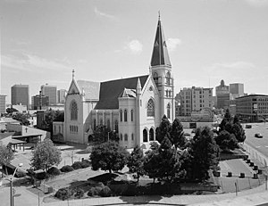
Cathedral of Saint Francis de Sales in Oakland was an 1893 church, which served as the cathedral of the Roman Catholic Diocese of Oakland in Oakland, California, from 1962 until it was damaged in the 1989 Loma Prieta earthquake.

19th Street Oakland station
Metro station in Oakland, California, US
Distance: Approx. 260 meters
Latitude and longitude: 37.807869,-122.26898
19th Street Oakland station (signed as 19th St/Oakland) is an underground Bay Area Rapid Transit (BART) station located under Broadway between 17th Street and 20th Street in the Uptown District of Oakland, California. It is a timed transfer point between northbound trains to Richmond and to Antioch. The station has three underground levels, with tracks on the second and third levels.

Fox Oakland Theatre
Concert hall, in Oakland, California
Distance: Approx. 146 meters
Latitude and longitude: 37.80888889,-122.26916667
The Fox Oakland Theatre is a 2,800-seat concert hall, a former movie theater, located at 1807 Telegraph Avenue in Downtown Oakland. It originally opened in 1928, running films until 1970. Designed by Weeks and Day, the theatre is listed on the National Register of Historic Places.
Oaksterdam, Oakland
Cultural district in Oakland, California
Distance: Approx. 333 meters
Latitude and longitude: 37.80721,-122.26917
Oaksterdam is a cultural district on the north end of Downtown Oakland, California, where medical cannabis is available for purchase in cafés, clubs, and patient dispensaries. Oaksterdam is located between downtown proper, the Lakeside, and the financial district. It is roughly bordered by 14th Street on the southwest, Harrison Street on the southeast, 19th Street on the northeast, and Telegraph Avenue on the northwest.

Oakland School for the Arts
Public charter school in Oakland, California, United States
Distance: Approx. 314 meters
Latitude and longitude: 37.80776944,-122.27091111
Oakland School for the Arts (OSA) is a visual and performing arts charter school in Oakland, California, United States. OSA opened in 2002 with a curriculum that integrated college preparatory academics with conservatory-style arts training. As of 2017, enrollment was 725 students in grades 6 through 12.

Key Route Inn
Hotel in California, United States
Distance: Approx. 250 meters
Latitude and longitude: 37.8114,-122.2667
The Key Route Inn was a major hotel in Oakland, California in the early decades of the 20th century. It was constructed by the Realty Syndicate of Francis "Borax" Smith and Frank C. Havens, a subsidiary of which was the Key Route transit system. The Inn opened on May 7, 1907, straddling what is now West Grand Avenue along the west side of Broadway.

Uptown Oakland
Neighborhood of Oakland in Alameda, California, United States
Distance: Approx. 168 meters
Latitude and longitude: 37.80937778,-122.27070833
Uptown Oakland is a neighborhood in Oakland, California, located in the northern end of Downtown. It is located roughly between West Grand Avenue to the north, Interstate 980 to the west, City Center and 14th Street to the south, and Broadway to the east. The neighborhood has become an important entertainment district in recent years.

Oakland Ballet
Ballet company based in Oakland, California
Distance: Approx. 202 meters
Latitude and longitude: 37.8111,-122.2671
The Oakland Ballet Company is a non-profit ballet company based in Oakland, California. OBC was founded in 1965 by Ronn Guidi, an Oakland native, and gained recognition through its historical reconstructions of ballets from the Ballets Russes of Serge Diaghilev; the mounting of classic works of Americana; and the creation of innovative contemporary choreography. Noted revivals by Oakland Ballet include works by choreographers Kurt Jooss, Michel Fokine, Charles Weidman, and Antony Tudor and the first re-staging of works by Bronislava Nijinska in the United States.

I. Magnin Building
Distance: Approx. 132 meters
Latitude and longitude: 37.809189,-122.268324
The I. Magnin Building is a former I. Magnin department store in Oakland, California located at 2001 Broadway. It was built in 1931 and designed by architecture firm Weeks and Day. It housed the upscale department store until it closed in 1995.

Reliance Athletic Club
Distance: Approx. 438 meters
Latitude and longitude: 37.807288,-122.272441
The Reliance Athletic Club was an athletic club and gentlemen's club in Oakland, California, United States. Founded in 1885, the organization grew rapidly as it added other sports and social activities, reaching its peak in the mid-1890s before financial troubles led to its bankruptcy and disestablishment in 1910.
Mary's First and Last Chance
Historic lesbian bar in Oakland, California
Distance: Approx. 255 meters
Latitude and longitude: 37.812459,-122.2686
Mary’s First and Last Chance (c. 1948 – 1956) was a lesbian and gay bar located at 2278 Telegraph Avenue in Oakland, California, U.S.. It was once the focus of the 1950s California Supreme Court lawsuit Vallerga v. Dept.
Weather in this IP's area
light rain
12 Celsius
11 Celsius
11 Celsius
13 Celsius
1022 hPa
81 %
1022 hPa
1022 hPa
10000 meters
1.54 m/s
300 degree
100 %