66.23.217.90 - IP Lookup: Free IP Address Lookup, Postal Code Lookup, IP Location Lookup, IP ASN, Public IP
Country:
Region:
City:
Location:
Time Zone:
Postal Code:
ISP:
ASN:
language:
User-Agent:
Proxy IP:
Blacklist:
IP information under different IP Channel
ip-api
Country
Region
City
ASN
Time Zone
ISP
Blacklist
Proxy
Latitude
Longitude
Postal
Route
db-ip
Country
Region
City
ASN
Time Zone
ISP
Blacklist
Proxy
Latitude
Longitude
Postal
Route
IPinfo
Country
Region
City
ASN
Time Zone
ISP
Blacklist
Proxy
Latitude
Longitude
Postal
Route
IP2Location
66.23.217.90Country
Region
illinois
City
westchester
Time Zone
America/Chicago
ISP
Language
User-Agent
Latitude
Longitude
Postal
ipdata
Country
Region
City
ASN
Time Zone
ISP
Blacklist
Proxy
Latitude
Longitude
Postal
Route
Popular places and events near this IP address

Broadview, Illinois
Village in Illinois, United States
Distance: Approx. 2717 meters
Latitude and longitude: 41.85944444,-87.85416667
Broadview is a village in Cook County, Illinois, United States, 12 miles (19 km) west of downtown Chicago. As of the 2020 census it had a population of 7,998.

Westchester, Illinois
Village in Illinois, United States
Distance: Approx. 236 meters
Latitude and longitude: 41.85388889,-87.88361111
Westchester is a village in Cook County, Illinois, United States. It is a western suburb of Chicago. The population was 16,892 at the 2020 census.

Mount Carmel Cemetery (Hillside, Illinois)
Cemetery in Hillside, Illinois
Distance: Approx. 2252 meters
Latitude and longitude: 41.86416667,-87.9075
Mount Carmel Cemetery is a Catholic cemetery in the Chicago suburb of Hillside, Illinois. Mount Carmel is an active cemetery, located within the Archdiocese of Chicago. It is located near the Eisenhower Expressway (Interstate 290) at Wolf and Roosevelt Roads.

Queen of Heaven Cemetery
Roman Catholic cemetery in Hillside, Illinois
Distance: Approx. 1791 meters
Latitude and longitude: 41.86222222,-87.9025
Queen of Heaven Cemetery is a Roman Catholic cemetery in Hillside, Illinois, a suburban community near Chicago. The cemetery is operated by the Archdiocese of Chicago. Queen of Heaven is located at Wolf and Roosevelt Roads, near the Eisenhower Expressway (Interstate 290), and is adjacent to another Catholic cemetery, Mount Carmel Cemetery.
St. Joseph High School (Westchester, Illinois)
Private school in Westchester, Illinois, United States
Distance: Approx. 738 meters
Latitude and longitude: 41.849264,-87.89341
St. Joseph High School (or St. Joe's) was a Roman Catholic, coeducational, college prep school in Westchester, Illinois, and was sponsored by the De La Salle Christian Brothers.

Proviso Township, Illinois
Township in Illinois, United States
Distance: Approx. 1834 meters
Latitude and longitude: 41.86444444,-87.87055556
Proviso Township is one of 29 townships in Cook County, Illinois, United States. As of the 2020 census, its population was 151,209. It was organized in 1850 and originally named "Taylor", but shortly afterward its name was changed to make reference to the Wilmot Proviso, a contemporary piece of legislation intended to stop the spread of slavery.
Addison Creek (Salt Creek tributary)
River in Illinois, United States
Distance: Approx. 2749 meters
Latitude and longitude: 41.8461424,-87.8533926
Addison Creek is a 10.7-mile-long (17.2 km) stream in the northeastern portion of the U.S. state of Illinois. It is a tributary of Salt Creek. Addison Creek originates in Bensenville and runs south and east through Northlake, Stone Park, Maywood, Bellwood, and Westchester.

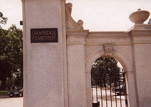
Oakridge Cemetery
Distance: Approx. 1225 meters
Latitude and longitude: 41.86277778,-87.89
Oakridge Cemetery is a cemetery located in the village of Hillside, near Chicago. It is the largest non-sectarian mausoleum in Cook County, Illinois. The cemetery is located at 4301 West Roosevelt Road, Hillside, IL 60162.
Roosevelt station (CTA Westchester branch)
Former Chicago "L" station
Distance: Approx. 1364 meters
Latitude and longitude: 41.86335,-87.87838
Roosevelt, originally known as Westchester, was a rapid transit station that served the Westchester branch of the Chicago "L" between 1926 and the branch's discontinuation in 1951. It was the branch's terminus from its opening until the 1930 extension of the line to 22nd Street.
Harrison station (CTA Westchester branch)
Former Chicago "L" station
Distance: Approx. 2161 meters
Latitude and longitude: 41.87104,-87.87868
Harrison was a rapid transit station on the Chicago "L" between 1926 and 1951 located on the Westchester branch.
Mannheim/22nd station
Former Chicago "L" station
Distance: Approx. 437 meters
Latitude and longitude: 41.849839,-87.881389
Mannheim/22nd was a rapid transit station on the Chicago "L" between 1930 and 1951. Located on the Westchester branch, it was the southern terminus of that branch, which was extended south to the station's location after having opened in 1926.
Canterbury station
Former Chicago "L" station
Distance: Approx. 763 meters
Latitude and longitude: 41.856279,-87.87801
Canterbury was a rapid transit station on the Chicago "L" between 1930 and 1951. Located on the Westchester branch, it was part of a southern extension of the branch, which had opened in 1926.
Weather in this IP's area
overcast clouds
-8 Celsius
-15 Celsius
-8 Celsius
-8 Celsius
1023 hPa
30 %
1023 hPa
996 hPa
10000 meters
4.37 m/s
6.04 m/s
342 degree
100 %