66.219.106.119 - IP Lookup: Free IP Address Lookup, Postal Code Lookup, IP Location Lookup, IP ASN, Public IP
Country:
 USA
USARegion:
City:
Location:
Time Zone:
Postal Code:
ISP:
ASN:
language:
User-Agent:
Proxy IP:
Blacklist:
IP information under different IP Channel
ip-api
Country
Region
City
ASN
Time Zone
ISP
Blacklist
Proxy
Latitude
Longitude
Postal
Route
db-ip
Country
Region
City
ASN
Time Zone
ISP
Blacklist
Proxy
Latitude
Longitude
Postal
Route
IPinfo
Country
Region
City
ASN
Time Zone
ISP
Blacklist
Proxy
Latitude
Longitude
Postal
Route
IP2Location
66.219.106.119Country
usRegion
north carolina
City
fayetteville
Time Zone
America/New_York
ISP
Language
User-Agent
Latitude
Longitude
Postal
ipdata
Country
Region
City
ASN
Time Zone
ISP
Blacklist
Proxy
Latitude
Longitude
Postal
Route
Popular places and events near this IP address
Cumberland County, North Carolina
County in North Carolina, United States
Distance: Approx. 3080 meters
Latitude and longitude: 35.05,-78.83
Cumberland County is a county located in the U.S. state of North Carolina. As of the 2020 census, the population was 334,728, making it the fifth-most populous county in North Carolina. Its county seat is Fayetteville.

Eastover, North Carolina
Town in North Carolina, United States
Distance: Approx. 4858 meters
Latitude and longitude: 35.10805556,-78.77944444
Eastover is a town in Cumberland County, North Carolina, United States. The population was 3,656 at the 2020 census. It was incorporated on July 25, 2007.
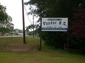
Vander, North Carolina
Census-designated place in North Carolina, United States
Distance: Approx. 4566 meters
Latitude and longitude: 35.03472222,-78.78861111
Vander is an unincorporated community and census-designated place (CDP) in Cumberland County, North Carolina, United States. The population was 1,388 at the 2020 census.

Cape Fear High School
American public school in North Carolina
Distance: Approx. 5989 meters
Latitude and longitude: 35.0346098,-78.7622433
Cape Fear High School is a public secondary school in the eastern region of Cumberland County in the unincorporated community of Vander, North Carolina, to the east of Fayetteville, North Carolina. The Cape Fear school attendance area is the largest in the county by area size.

Fayetteville Area System of Transit
Public transit system
Distance: Approx. 5620 meters
Latitude and longitude: 35.05507778,-78.86761667
Fayetteville Area System of Transit (FAST) is the public transit system for Fayetteville, North Carolina. FAST was created in 1976, when the City of Fayetteville took over private transportation system operated by the Cape Fear Transit Bus Company. That system provided services to the current service area and Little Rockfish in Hope Mills.

Cape Fear Botanical Garden
Botanical garden in Fayetteville, NC
Distance: Approx. 4918 meters
Latitude and longitude: 35.0542,-78.8589
Cape Fear Botanical Garden (80 acres) is a nonprofit botanical garden located at 536 North Eastern Boulevard, Fayetteville, North Carolina. It is open to the public daily (excluding some holidays and in event of inclement weather); an admission fee is charged. The Garden was established in 1989 to serve both Fayetteville Technical Community College horticulture students and North Carolina horticulturalists.

Hay Street United Methodist Church
Historic church in North Carolina, United States
Distance: Approx. 6258 meters
Latitude and longitude: 35.05305556,-78.87416667
Hay Street United Methodist Church is a historic Methodist church located in Fayetteville, Cumberland County, North Carolina. It was the first Methodist church constructed in the city. The congregation was received into the Methodist Episcopal Church in 1808 by Bishop Francis Asbury and it was completed on June 23, 1835.

Cross Creek Cemetery
Historic cemetery in Cumberland County, North Carolina, US
Distance: Approx. 5857 meters
Latitude and longitude: 35.05861111,-78.87166667
Cross Creek Cemetery is a cemetery located in Fayetteville, North Carolina, near a creek of that name that "meanders for more than a mile from downtown Fayetteville to the Cape Fear River." It was established in 1785. The cemetery is organized into five numbered sections and is managed by a cemetery office within Fayetteville–Cumberland County Parks & Recreation.

Cool Spring Place
Historic house in North Carolina, United States
Distance: Approx. 6289 meters
Latitude and longitude: 35.05208333,-78.87408333
Cool Spring Place, also known as Cool Spring Tavern, is a historic home located at Fayetteville, Cumberland County, North Carolina. It was built in 1788, and is a two-story, five bay by four bay, rectangular Federal-style frame dwelling. It low hipped roof and features a double porch on the front facade.

Robert Williams House
Historic house in North Carolina, United States
Distance: Approx. 1841 meters
Latitude and longitude: 35.08777778,-78.81555556
Robert Williams House is a historic home located near Eastover, Cumberland County, North Carolina. It was built about 1850, and is a 1+1⁄2-story Greek Revival style Coastal Cottage form dwelling. It has a gable roof with exterior end chimneys and features an engaged porch.
Gully Mill
United States historic place
Distance: Approx. 3402 meters
Latitude and longitude: 35.05611111,-78.84138889
Gully Mill is a historic grist mill located on the Cape Fear River near Fayetteville, Cumberland County, North Carolina. The mill was built about 1900, and consists of one and two story sections, a large water wheel operated by water flowing through a partially underground flume, and an open rear shed. Also on the property are a miller's house, corrugated metal storage silos, a chicken coop, and miscellaneous related structures.
Cross Creek (Cape Fear River tributary)
Stream in North Carolina, USA
Distance: Approx. 4909 meters
Latitude and longitude: 35.05111111,-78.85694444
Cross Creek is a 9.70 mi (15.61 km) long 4th order tributary to the Cape Fear River in Cumberland County, North Carolina.
Weather in this IP's area
overcast clouds
9 Celsius
6 Celsius
8 Celsius
9 Celsius
1028 hPa
72 %
1028 hPa
1023 hPa
10000 meters
6.17 m/s
8.75 m/s
90 degree
100 %