66.207.114.29 - IP Lookup: Free IP Address Lookup, Postal Code Lookup, IP Location Lookup, IP ASN, Public IP
Country:
Region:
City:
Location:
Time Zone:
Postal Code:
ISP:
ASN:
language:
User-Agent:
Proxy IP:
Blacklist:
IP information under different IP Channel
ip-api
Country
Region
City
ASN
Time Zone
ISP
Blacklist
Proxy
Latitude
Longitude
Postal
Route
db-ip
Country
Region
City
ASN
Time Zone
ISP
Blacklist
Proxy
Latitude
Longitude
Postal
Route
IPinfo
Country
Region
City
ASN
Time Zone
ISP
Blacklist
Proxy
Latitude
Longitude
Postal
Route
IP2Location
66.207.114.29Country
Region
ontario
City
brantford
Time Zone
America/Toronto
ISP
Language
User-Agent
Latitude
Longitude
Postal
ipdata
Country
Region
City
ASN
Time Zone
ISP
Blacklist
Proxy
Latitude
Longitude
Postal
Route
Popular places and events near this IP address

Brantford
City in Ontario, Canada
Distance: Approx. 3149 meters
Latitude and longitude: 43.15694444,-80.2575
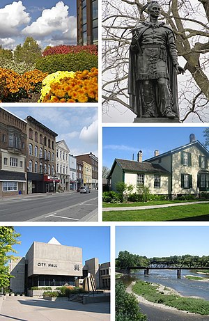
Brantford (2021 population: 104,688) is a city in Ontario, Canada, founded on the Grand River in Southwestern Ontario. It is surrounded by Brant County but is politically separate with a municipal government of its own that is fully independent of the county's municipal government. Brantford is situated on the Haldimand Tract, and is named after Joseph Brant, a Mohawk leader, soldier, farmer and slave owner.

Pauline Johnson Collegiate & Vocational School
High school in Brantford, Ontario, Canada
Distance: Approx. 2152 meters
Latitude and longitude: 43.13939,-80.23927
Pauline Johnson Collegiate & Vocational School in Brantford, Ontario, Canada is a composite high school with collegiate and vocational departments. It was named in honour of the Canadian First Nations poet E. Pauline Johnson, who was born nearby. The school was officially opened on October 18, 1955.

Mohawk Chapel
Church
Distance: Approx. 3334 meters
Latitude and longitude: 43.124432,-80.235
His Majesty's Royal Chapel of the Mohawks in Brantford, Ontario is the oldest surviving church building in Ontario and was the first Anglican church in Upper Canada. It is one of only three Chapels Royal in Canada. In 1981, the chapel was designated a National Historic Site of Canada.
Laurier Brantford
Campus of Wilfrid Laurier University in Ontario, Canada
Distance: Approx. 3690 meters
Latitude and longitude: 43.14,-80.2616
Laurier Brantford is Wilfrid Laurier University's second campus located in Brantford, Ontario. The first and original campus of Wilfrid Laurier University is located in Waterloo, Ontario. Laurier follows a 'multicampus' structure, as it is one university with multiple campuses.
Cainsville, Ontario
Unincorporated community in Ontario, Canada
Distance: Approx. 1783 meters
Latitude and longitude: 43.14603,-80.1989898
Cainsville is a community straddling the boundary of Brantford and Brant County in Ontario, Canada. Cainsville started off as a rural Black Canadian settlement called Bunnell's Landing. Joseph Brant had given an initial land grant to a handful of free, formerly enslaved Africans.

Brantford City Hall
Municipal building in Ontario, Canada
Distance: Approx. 3665 meters
Latitude and longitude: 43.14194444,-80.26222222
Brantford City Hall is the home of the municipal government of Brantford, Ontario, Canada. The building is located at 100 Wellington Square. Designed by Michael Kopsa and built in 1967, it is exemplary of Brutalist architecture.

Echo Place
Distance: Approx. 326 meters
Latitude and longitude: 43.150101,-80.21636
Echo Place is a community in Brantford, Ontario. Incorporated in 1865 east of Brantford, it was built around Springbrook Hotel. The 1891 census found a population of 30, including three businesses: A general store/post office, a nursery and an oatmeal mill.
Brant Haldimand Norfolk Catholic District School Board
Distance: Approx. 3702 meters
Latitude and longitude: 43.17055556,-80.25722222
The Brant Haldimand Norfolk Catholic District School Board (BHNCDSB, known as English-language Separate District School Board No. 51 prior to 1999) is a separate school board in Ontario, Canada. The school board is the school district administrator for the communities of the County of Brant, Haldimand County, and Norfolk County, Ontario.

Brantford Jail
Jail in Ontario, Canada
Distance: Approx. 3744 meters
Latitude and longitude: 43.14196,-80.26325
The Brantford Jail was a jail in downtown Brantford, Ontario. It was closed in December 2017. It was slated for closure in 2012, along with the Chatham Jail and the Toronto West Detention Centre.

Mohawk Institute Residential School
Canadian indigenous residential school in Canada
Distance: Approx. 3221 meters
Latitude and longitude: 43.1276,-80.24039
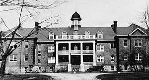
The Mohawk Institute Residential School was a Canadian Indian residential school in Brantford, Ontario, Canada. The school operated from 1831 to June 27, 1970. Enrollment at the school ranged from 90 to 200 students per year.
Glebe Farm 40B
Indian reserve in Ontario, Canada
Distance: Approx. 2380 meters
Latitude and longitude: 43.13333333,-80.23333333
Glebe Farm 40B is a shared First Nations reserve within the city of Brantford. It is shared between the Bay of Quinte Mohawks, Bearfoot Onondaga, Delaware, Konadaha Seneca, Lower Cayuga, Lower Mohawk, Niharondasa Seneca, Oneida, Onondaga Clear Sky, Tuscarora, Upper Cayuga, Upper Mohawk & Walker Mohawk First Nations.
Kanata Village
Tourist attraction in Brantford, Ontario
Distance: Approx. 2838 meters
Latitude and longitude: 43.1285,-80.2325
Kanata Village was a tourist attraction in Brantford, Ontario made by the Pine Tree Native Centre. It was an attraction meant to give “The 17th century Iroquois experience.” There is a longhouse and while it was active, there were various demonstrations of 17th century Iroquois life such as “making fire by friction, tanning hides, pounding corn, and playing First Nations games like double ball and snow snake.” Kanata Village opened in 2000 and was considered the best new attraction in Ontario that year. On May 8, 2003, fires were set in the village by arsonists and the longhouse was destroyed.
Weather in this IP's area
overcast clouds
-7 Celsius
-14 Celsius
-7 Celsius
-5 Celsius
1019 hPa
72 %
1019 hPa
988 hPa
10000 meters
6.92 m/s
10.52 m/s
278 degree
100 %
