66.207.114.173 - IP Lookup: Free IP Address Lookup, Postal Code Lookup, IP Location Lookup, IP ASN, Public IP
Country:
Region:
City:
Location:
Time Zone:
Postal Code:
IP information under different IP Channel
ip-api
Country
Region
City
ASN
Time Zone
ISP
Blacklist
Proxy
Latitude
Longitude
Postal
Route
Luminati
Country
Region
on
City
brantford
ASN
Time Zone
America/Toronto
ISP
BRRD-AS
Latitude
Longitude
Postal
IPinfo
Country
Region
City
ASN
Time Zone
ISP
Blacklist
Proxy
Latitude
Longitude
Postal
Route
IP2Location
66.207.114.173Country
Region
ontario
City
brantford
Time Zone
America/Toronto
ISP
Language
User-Agent
Latitude
Longitude
Postal
db-ip
Country
Region
City
ASN
Time Zone
ISP
Blacklist
Proxy
Latitude
Longitude
Postal
Route
ipdata
Country
Region
City
ASN
Time Zone
ISP
Blacklist
Proxy
Latitude
Longitude
Postal
Route
Popular places and events near this IP address

Brantford
City in Ontario, Canada
Distance: Approx. 2635 meters
Latitude and longitude: 43.15694444,-80.2575
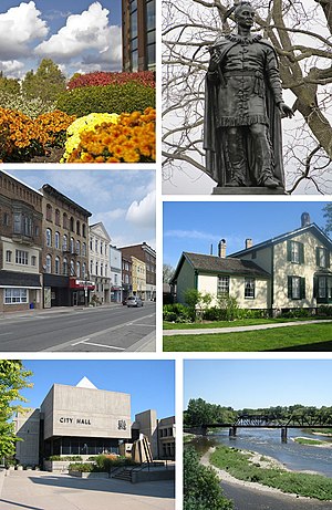
Brantford (2021 population: 104,688) is a city in Ontario, Canada, founded on the Grand River in Southwestern Ontario. It is surrounded by Brant County but is politically separate with a municipal government of its own that is fully independent of the county's municipal government. Brantford is situated on the Haldimand Tract, and is named after Joseph Brant, a Mohawk leader, soldier, farmer and slave owner.

Pauline Johnson Collegiate & Vocational School
High school in Brantford, Ontario, Canada
Distance: Approx. 4211 meters
Latitude and longitude: 43.13939,-80.23927
Pauline Johnson Collegiate & Vocational School in Brantford, Ontario, Canada is a composite high school with collegiate and vocational departments. It was named in honour of the Canadian First Nations poet E. Pauline Johnson, who was born nearby. The school was officially opened on October 18, 1955.

W. Ross Macdonald School
School in Brantford, Ontario, Canada
Distance: Approx. 4484 meters
Latitude and longitude: 43.15257,-80.2844
The W. Ross Macdonald School was founded in March 1872 in Brantford, Ontario, Canada. Its first principal was Ezekiel Stone Wiggins. It provides instruction from kindergarten to secondary school graduation for blind and deafblind students.
North Park Collegiate and Vocational School
High school in Brantford, Ontario, Canada
Distance: Approx. 1989 meters
Latitude and longitude: 43.168409,-80.262036
North Park Collegiate and Vocational School is a public secondary school (high school) located in Brantford, Ontario, Canada, that offers academic courses to students in grades 9 through 12.

CFWC-FM
Radio station in Brantford, Ontario, Canada
Distance: Approx. 3591 meters
Latitude and longitude: 43.15138889,-80.26722222
CFWC-FM (93.9 MHz, Hot Country 93.9) is a radio station in Brantford, Ontario. Owned by Evanov Communications, the station broadcasts a country format. The studios are located at 325 West St in Brantford while its transmitter is located atop a church steeple at Dundas St and Sydenham St in Brantford.
Laurier Brantford
Campus of Wilfrid Laurier University in Ontario, Canada
Distance: Approx. 4475 meters
Latitude and longitude: 43.14,-80.2616
Laurier Brantford is Wilfrid Laurier University's second campus located in Brantford, Ontario. The first and original campus of Wilfrid Laurier University is located in Waterloo, Ontario. Laurier follows a 'multicampus' structure, as it is one university with multiple campuses.

Brantford City Hall
Municipal building in Ontario, Canada
Distance: Approx. 4296 meters
Latitude and longitude: 43.14194444,-80.26222222
Brantford City Hall is the home of the municipal government of Brantford, Ontario, Canada. The building is located at 100 Wellington Square. Designed by Michael Kopsa and built in 1967, it is exemplary of Brutalist architecture.

Echo Place
Distance: Approx. 3606 meters
Latitude and longitude: 43.150101,-80.21636
Echo Place is a community in Brantford, Ontario. Incorporated in 1865 east of Brantford, it was built around Springbrook Hotel. The 1891 census found a population of 30, including three businesses: A general store/post office, a nursery and an oatmeal mill.
Brant Haldimand Norfolk Catholic District School Board
Distance: Approx. 1532 meters
Latitude and longitude: 43.17055556,-80.25722222
The Brant Haldimand Norfolk Catholic District School Board (BHNCDSB, known as English-language Separate District School Board No. 51 prior to 1999) is a separate school board in Ontario, Canada. The school board is the school district administrator for the communities of the County of Brant, Haldimand County, and Norfolk County, Ontario.

Brantford station
Railway station in Ontario, Canada
Distance: Approx. 3953 meters
Latitude and longitude: 43.14666667,-80.26555556
Brantford railway station in Brantford, Ontario, Canada is a railway station serving Via Rail trains running between Toronto and Windsor. The station also serves the nearby towns of Paris and Simcoe.

Brantford Jail
Jail in Ontario, Canada
Distance: Approx. 4329 meters
Latitude and longitude: 43.14196,-80.26325
The Brantford Jail was a jail in downtown Brantford, Ontario. It was closed in December 2017. It was slated for closure in 2012, along with the Chatham Jail and the Toronto West Detention Centre.

The Sanderson Centre
Distance: Approx. 4581 meters
Latitude and longitude: 43.13994,-80.26464
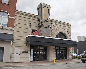
The Sanderson Centre for the Performing Arts is a heritage theatre and concert hall located in the heart of downtown Brantford, Ontario. The Sanderson Centre seats 1,125 people and is a home for local performing arts organizations like the Brantford Symphony Orchestra and provides a venue for school and community events, recitals and amateur dance competitions. The Sanderson Centre also offers a season of professional entertainment and arts programming.
Weather in this IP's area
overcast clouds
2 Celsius
-2 Celsius
1 Celsius
3 Celsius
1021 hPa
96 %
1021 hPa
994 hPa
10000 meters
4.22 m/s
8.55 m/s
77 degree
100 %
