66.207.113.112 - IP Lookup: Free IP Address Lookup, Postal Code Lookup, IP Location Lookup, IP ASN, Public IP
Country:
Region:
City:
Location:
Time Zone:
Postal Code:
IP information under different IP Channel
ip-api
Country
Region
City
ASN
Time Zone
ISP
Blacklist
Proxy
Latitude
Longitude
Postal
Route
Luminati
Country
Region
on
City
brantford
ASN
Time Zone
America/Toronto
ISP
BRRD-AS
Latitude
Longitude
Postal
IPinfo
Country
Region
City
ASN
Time Zone
ISP
Blacklist
Proxy
Latitude
Longitude
Postal
Route
IP2Location
66.207.113.112Country
Region
ontario
City
brantford
Time Zone
America/Toronto
ISP
Language
User-Agent
Latitude
Longitude
Postal
db-ip
Country
Region
City
ASN
Time Zone
ISP
Blacklist
Proxy
Latitude
Longitude
Postal
Route
ipdata
Country
Region
City
ASN
Time Zone
ISP
Blacklist
Proxy
Latitude
Longitude
Postal
Route
Popular places and events near this IP address

Pauline Johnson Collegiate & Vocational School
High school in Brantford, Ontario, Canada
Distance: Approx. 613 meters
Latitude and longitude: 43.13939,-80.23927
Pauline Johnson Collegiate & Vocational School in Brantford, Ontario, Canada is a composite high school with collegiate and vocational departments. It was named in honour of the Canadian First Nations poet E. Pauline Johnson, who was born nearby. The school was officially opened on October 18, 1955.

Brantford Civic Centre
Arena in Ontario
Distance: Approx. 1612 meters
Latitude and longitude: 43.13527778,-80.265
The Brantford and District Civic Centre (More commonly known as simply the Brantford Civic Centre) is a 2,952-seat arena in Brantford, Ontario, Canada. It was built as a Canadian Centennial project in 1967. The Civic Centre is located in the downtown core, adjacent to Elements Casino Brantford.

The Ford Plant
Non-profit music venue in Brantford, Canada
Distance: Approx. 1685 meters
Latitude and longitude: 43.13833333,-80.26708333
The Ford Plant was a not-for-profit music venue founded in 2002. Throughout its history it functioned as an art gallery (the One King Gallery), studio, music store, and record label. The venue was located in downtown Brantford, Ontario, Canada, an area well known for its festivals and social experiences.
Laurier Brantford
Campus of Wilfrid Laurier University in Ontario, Canada
Distance: Approx. 1221 meters
Latitude and longitude: 43.14,-80.2616
Laurier Brantford is Wilfrid Laurier University's second campus located in Brantford, Ontario. The first and original campus of Wilfrid Laurier University is located in Waterloo, Ontario. Laurier follows a 'multicampus' structure, as it is one university with multiple campuses.

Brantford City Hall
Municipal building in Ontario, Canada
Distance: Approx. 1276 meters
Latitude and longitude: 43.14194444,-80.26222222
Brantford City Hall is the home of the municipal government of Brantford, Ontario, Canada. The building is located at 100 Wellington Square. Designed by Michael Kopsa and built in 1967, it is exemplary of Brutalist architecture.

Brantford station
Railway station in Ontario, Canada
Distance: Approx. 1677 meters
Latitude and longitude: 43.14666667,-80.26555556
Brantford railway station in Brantford, Ontario, Canada is a railway station serving Via Rail trains running between Toronto and Windsor. The station also serves the nearby towns of Paris and Simcoe.

Brantford Jail
Jail in Ontario, Canada
Distance: Approx. 1360 meters
Latitude and longitude: 43.14196,-80.26325
The Brantford Jail was a jail in downtown Brantford, Ontario. It was closed in December 2017. It was slated for closure in 2012, along with the Chatham Jail and the Toronto West Detention Centre.

Bell Memorial
Monument in Brantford, Ontario, Canada
Distance: Approx. 1743 meters
Latitude and longitude: 43.14111111,-80.26805556
The Bell Memorial (also known as the Bell Monument or Telephone Monument) is a memorial designed by Walter Seymour Allward to commemorate the invention of the telephone by Alexander Graham Bell at the Bell Homestead National Historic Site, in Brantford, Ontario, Canada. In 1906, the citizens of the Brantford and Brant County areas formed the Bell Telephone Memorial Association, which commissioned the memorial. By 1908, the association's designs committee asked sculptors on two continents to submit proposals for the memorial.

The Sanderson Centre
Distance: Approx. 1468 meters
Latitude and longitude: 43.13994,-80.26464
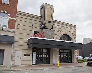
The Sanderson Centre for the Performing Arts is a heritage theatre and concert hall located in the heart of downtown Brantford, Ontario. The Sanderson Centre seats 1,125 people and is a home for local performing arts organizations like the Brantford Symphony Orchestra and provides a venue for school and community events, recitals and amateur dance competitions. The Sanderson Centre also offers a season of professional entertainment and arts programming.

Mohawk Institute Residential School
Canadian indigenous residential school in Canada
Distance: Approx. 1543 meters
Latitude and longitude: 43.1276,-80.24039
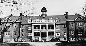
The Mohawk Institute Residential School was a Canadian Indian residential school in Brantford, Ontario, Canada. The school operated from 1831 to June 27, 1970. Enrollment at the school ranged from 90 to 200 students per year.
Glebe Farm 40B
Indian reserve in Ontario, Canada
Distance: Approx. 1354 meters
Latitude and longitude: 43.13333333,-80.23333333
Glebe Farm 40B is a shared First Nations reserve within the city of Brantford. It is shared between the Bay of Quinte Mohawks, Bearfoot Onondaga, Delaware, Konadaha Seneca, Lower Cayuga, Lower Mohawk, Niharondasa Seneca, Oneida, Onondaga Clear Sky, Tuscarora, Upper Cayuga, Upper Mohawk & Walker Mohawk First Nations.

Brantford station (Toronto, Hamilton and Buffalo Railway)
Railway station in Brantford, Ontario, Canada
Distance: Approx. 1461 meters
Latitude and longitude: 43.1347,-80.2626
The Brantford Station is a former Toronto, Hamilton & Buffalo Railway station, located in Brantford, Ontario. After closing as a railway station, it was sold in 1969 and operated as a steak house from 1970 until it closed in 2007.
Weather in this IP's area
broken clouds
6 Celsius
4 Celsius
5 Celsius
7 Celsius
1018 hPa
95 %
1018 hPa
992 hPa
10000 meters
2.61 m/s
3.42 m/s
235 degree
78 %
