Country:
 USA
USARegion:
City:
Latitude and Longitude:
Time Zone:
Postal Code:
IP information under different IP Channel
ip-api
Country
Region
City
ASN
Time Zone
ISP
Blacklist
Proxy
Latitude
Longitude
Postal
Route
IPinfo
Country
Region
City
ASN
Time Zone
ISP
Blacklist
Proxy
Latitude
Longitude
Postal
Route
MaxMind
Country
Region
City
ASN
Time Zone
ISP
Blacklist
Proxy
Latitude
Longitude
Postal
Route
Luminati
Country
USRegion
ne
City
centralcity
ASN
Time Zone
America/Chicago
ISP
NEDELCO
Latitude
Longitude
Postal
db-ip
Country
Region
City
ASN
Time Zone
ISP
Blacklist
Proxy
Latitude
Longitude
Postal
Route
ipdata
Country
Region
City
ASN
Time Zone
ISP
Blacklist
Proxy
Latitude
Longitude
Postal
Route
Popular places and events near this IP address

Merrick County, Nebraska
County in Nebraska, United States
Distance: Approx. 5833 meters
Latitude and longitude: 41.17,-98.03
Merrick County is a county in the U.S. state of Nebraska. As of the 2020 United States Census, the population was 7,668. Its county seat is Central City.
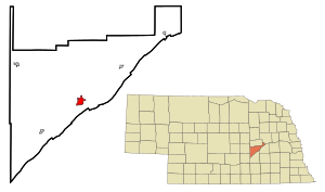
Central City, Nebraska
City in Nebraska, United States
Distance: Approx. 1335 meters
Latitude and longitude: 41.11361111,-97.99055556
Central City is a city and the county seat of Merrick County, Nebraska, United States. It is part of the Grand Island metropolitan area. The population was 3,039 at the 2020 census.
KMMJ
Radio station in Grand Island, Nebraska
Distance: Approx. 1554 meters
Latitude and longitude: 41.13472222,-97.99388889
KMMJ (750 AM) is a radio station broadcasting a Spanish Christian contemporary format. Licensed to Grand Island, Nebraska, United States, the station serves the Grand Island, Hastings, Kearney area. The station is currently owned by My Bridge Radio.

Lone Tree Township, Merrick County, Nebraska
Township in Nebraska, United States
Distance: Approx. 2087 meters
Latitude and longitude: 41.12138889,-98.02666667
Lone Tree Township is one of eleven townships in Merrick County, Nebraska, United States. The population was 627 at the 2020 census. A 2021 estimate placed the township's population at 626.

Overland, Nebraska
Census-designated place in Nebraska, United States
Distance: Approx. 4998 meters
Latitude and longitude: 41.08083333,-97.97833333
Overland is a census-designated place (CDP) in Hamilton County, Nebraska, United States. The population was 153 at the 2010 census.

Lone Tree Monument
Monument in Central City, Nebraska
Distance: Approx. 5638 meters
Latitude and longitude: 41.074,-98.02283333
The Lone Tree Monument is on the site once occupied by a large tree in central Nebraska. Native Americans held council under it, early pioneers used it as a landmark, and it was the first official name of the county seat of Merrick county. It is marked as a historical location by the Nebraska State Historical Society.

Merrick County Courthouse
United States historic place
Distance: Approx. 965 meters
Latitude and longitude: 41.11361111,-97.99944444
The Merrick County Courthouse was built from 1911 to 1913 in Central City, Nebraska, United States. Designed in the Classical Revival style by architect William F. Gernandt, it was built at a cost of $100,000. In 1990, it was listed in the National Register of Historic Places, but was removed from the Register in 2014.

Patterson Law Office
United States historic place
Distance: Approx. 910 meters
Latitude and longitude: 41.11416667,-97.99916667
The Patterson Law Office is located in Central City, Nebraska. It is a false-front building of frame construction built in 1872. It is listed in the National Register of Historic Places; its historical significance derives from its age, its architectural design, and its association with John Patterson and with author-photographer Wright Morris.

Wright Morris Boyhood House
Historic house in Nebraska, United States
Distance: Approx. 2200 meters
Latitude and longitude: 41.11722222,-98.02722222
The Wright Morris Boyhood House is a vernacular-style house built in 1893 in Central City, Nebraska. It is listed in the National Register of Historic Places, as the boyhood home of author-photographer Wright Morris.
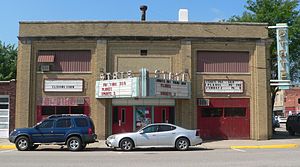
Martha Ellen Auditorium
United States historic place
Distance: Approx. 828 meters
Latitude and longitude: 41.11472222,-98.00305556
The Martha Ellen Auditorium, now the State Theatre, was built 1916 in Central City, the county seat of Merrick County in the state of Nebraska in the midwestern United States. It is listed in the National Register of Historic Places, as a well-preserved example of a Nebraska opera house.
Riverside Park Dance Pavilion
United States historic place
Distance: Approx. 3861 meters
Latitude and longitude: 41.09722222,-97.96972222
The Riverside Park Dance Pavilion is in Merrick County, Nebraska. It was built in 1940 with the aim of reviving the Riverside Park area. At its peak, dances were held twice a week drawing people from central Nebraska.

Heber Hord House
United States historic place
Distance: Approx. 1311 meters
Latitude and longitude: 41.11611111,-97.98833333
The Heber Hord House is a two-story frame house in Central City, Nebraska. It was designed by Omaha architects Fisher and Lawrie, and built in 1906 by Heber Hord, the only son of Thomas Benton (T. B.) Hord, a prominent business man and cattle rancher in Nebraska during the late 19th and early 20th centuries. It is listed in the National Register of Historic Places.
Weather in this IP's area
light rain
20 Celsius
19 Celsius
20 Celsius
21 Celsius
1016 hPa
39 %
1016 hPa
958 hPa
10000 meters
9.02 m/s
12.32 m/s
187 degree
87 %
07:47:18
18:46:27