Country:
Region:
City:
Latitude and Longitude:
Time Zone:
Postal Code:
IP information under different IP Channel
ip-api
Country
Region
City
ASN
Time Zone
ISP
Blacklist
Proxy
Latitude
Longitude
Postal
Route
IPinfo
Country
Region
City
ASN
Time Zone
ISP
Blacklist
Proxy
Latitude
Longitude
Postal
Route
MaxMind
Country
Region
City
ASN
Time Zone
ISP
Blacklist
Proxy
Latitude
Longitude
Postal
Route
Luminati
Country
Region
ne
City
doniphan
ASN
Time Zone
America/Chicago
ISP
NEDELCO
Latitude
Longitude
Postal
db-ip
Country
Region
City
ASN
Time Zone
ISP
Blacklist
Proxy
Latitude
Longitude
Postal
Route
ipdata
Country
Region
City
ASN
Time Zone
ISP
Blacklist
Proxy
Latitude
Longitude
Postal
Route
Popular places and events near this IP address
Doniphan, Nebraska
Village in Hall County, Nebraska, United States
Distance: Approx. 506 meters
Latitude and longitude: 40.77444444,-98.37138889
Doniphan is a village in Hall County, Nebraska, United States. The population was 809 at the 2020 census. It is part of the Grand Island, Nebraska Micropolitan Statistical Area.
KROA
Radio station in Grand Island, Nebraska
Distance: Approx. 1692 meters
Latitude and longitude: 40.78638889,-98.367
KROA (95.7 FM) is a radio station broadcasting a Christian contemporary format. Licensed to Grand Island, Nebraska, United States, the station serves the Grand Island-Kearney area. The station is currently owned by My Bridge Radio.

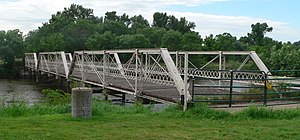
Nine Bridges Bridge
United States historic place
Distance: Approx. 6068 meters
Latitude and longitude: 40.82777778,-98.37972222
The Nine Bridges Bridge near Doniphan, Nebraska was built in 1913. It was built by the Standard Bridge Co. using Jones & Laughlin Steel Co.-rolled components.
Alda Township, Hall County, Nebraska
Distance: Approx. 8097 meters
Latitude and longitude: 40.829,-98.439
Alda Township is a township in Hall County, Nebraska, in the United States.
South Platte Township, Hall County, Nebraska
Township in Hall County, Nebraska
Distance: Approx. 5789 meters
Latitude and longitude: 40.743,-98.433
South Platte Township is a township in Hall County, Nebraska, in the United States.
Doniphan Township, Hall County, Nebraska
Distance: Approx. 4158 meters
Latitude and longitude: 40.776,-98.328
Doniphan Township is a township in Hall County, Nebraska, in the United States.
Platte Generating Station
Distance: Approx. 9391 meters
Latitude and longitude: 40.85472222,-98.34805556
Platte Generating Station is a single unit 100 MW (megawatt) (110 MW nameplate) coal-fired power plant owned and operated by the City of Grand Island located in Grand Island, Nebraska. The plant entered commercial service in 1982. It serves the city of Grand Island as their primary source of electricity.
Weather in this IP's area
clear sky
12 Celsius
11 Celsius
10 Celsius
14 Celsius
1021 hPa
75 %
1021 hPa
952 hPa
10000 meters
1.34 m/s
1.79 m/s
151 degree
07:07:57
19:54:24
