66.193.160.184 - IP Lookup: Free IP Address Lookup, Postal Code Lookup, IP Location Lookup, IP ASN, Public IP
Country:
 USA
USARegion:
City:
Location:
Time Zone:
Postal Code:
ISP:
ASN:
language:
User-Agent:
Proxy IP:
Blacklist:
IP information under different IP Channel
ip-api
Country
Region
City
ASN
Time Zone
ISP
Blacklist
Proxy
Latitude
Longitude
Postal
Route
db-ip
Country
Region
City
ASN
Time Zone
ISP
Blacklist
Proxy
Latitude
Longitude
Postal
Route
IPinfo
Country
Region
City
ASN
Time Zone
ISP
Blacklist
Proxy
Latitude
Longitude
Postal
Route
IP2Location
66.193.160.184Country
usRegion
florida
City
kissimmee
Time Zone
America/New_York
ISP
Language
User-Agent
Latitude
Longitude
Postal
ipdata
Country
Region
City
ASN
Time Zone
ISP
Blacklist
Proxy
Latitude
Longitude
Postal
Route
Popular places and events near this IP address

Campbell, Florida
CDP in Florida, United States
Distance: Approx. 915 meters
Latitude and longitude: 28.26027778,-81.4525
Campbell (often referred to locally as Campbell City) is a census-designated place and an unincorporated community in Osceola County, Florida, United States. Campbell City was named after Alfred Sidney Campbell who opened and operated the general store in the settlement. The population was 2,479 at the 2010 census.

Kissimmee Air Museum
Distance: Approx. 4233 meters
Latitude and longitude: 28.2944,-81.44623
The Kissimmee Air Museum was located at the Kissimmee Gateway Airport in Kissimmee, Florida. It housed vintage aircraft from World War II to the Vietnam War including an outdoor showroom. It was a working museum that restored vintage aircraft.

Kissimmee Gateway Airport
Airport in Florida, U.S.
Distance: Approx. 4187 meters
Latitude and longitude: 28.28972222,-81.43722222
Kissimmee Gateway Airport (IATA: ISM, ICAO: KISM, FAA LID: ISM), formerly known as Kissimmee Municipal Airport, is a public airport in Kissimmee, a city in Osceola County, Florida, United States. The airport is located 16 nautical miles (30 km) southwest of the central business district of Orlando. It is owned and operated by the City of Kissimmee.
Osceola High School (Kissimmee, Florida)
Public high school in Kissimmee, Florida, United States
Distance: Approx. 4660 meters
Latitude and longitude: 28.287712,-81.427212
Osceola High School (OHS) is a public high school located in Kissimmee, Florida, USA. The school was established on September 5, 1887 along with 20 other schools in Osceola County. It was referred to as "the Kissimmee school" until it was renamed "Osceola High School" in 1889.
Give Kids the World Village
Nonprofit resort in Florida for critically ill children
Distance: Approx. 3522 meters
Latitude and longitude: 28.290324,-81.457508
Give Kids The World Village is an 89-acre nonprofit resort in Kissimmee, Florida that provides critically ill children and their families with week-long wish vacations at no cost. Half of all critically ill children eligible for a wish choose to visit Central Florida and its theme parks. Give Kids The World aims to fulfill that wish, providing children and their families with all-inclusive vacations including transportation, accommodations, food, theme park tickets, and entertainment.

Intercession City, Florida
Unincorporated Community in Florida, United States
Distance: Approx. 4536 meters
Latitude and longitude: 28.2625,-81.50777778
Intercession City is an unincorporated community located in central Florida, United States, approximately five miles west of Kissimmee, in Osceola County, on Highway 17/92. Osceola County is in the Eastern time zone UTC-5. The average high temperature in July is 91.3 degrees, with an average low temperature in January of 47.2 degrees.
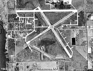
Kissimmee Army Airfield
Distance: Approx. 4187 meters
Latitude and longitude: 28.28972222,-81.43722222
Kissimmee Army Airfield, was a United States Army Air Forces airfield during World War II, located 1.8 miles (2.9 km) west of Kissimmee, Florida.

Poinciana station
Distance: Approx. 2223 meters
Latitude and longitude: 28.258829,-81.484368
SunRail Poinciana station is a train station in the community of Poinciana, Florida. It is the southern terminus of SunRail, the commuter rail service of Greater Orlando. The station opened on July 30, 2018.

Osceola County Welcome Center and History Museum
Museum in Kissimmee, Florida, US
Distance: Approx. 5254 meters
Latitude and longitude: 28.3049,-81.4497
Osceola County Welcome Center and History Museum is in Kissimmee, Osceola County, Florida. It includes the Osceola County Historical Society Museum's local history exhibits as well as Pioneer Village and its 1889 Ross Lanier House, blacksmith shop, one-room schoolhouse, 1882 citrus packing house, general store, and "cracker house" cow camp. The center includes a multi-purpose room with 50 theater style seats and mini-kitchen.
Makinson Island
Distance: Approx. 5490 meters
Latitude and longitude: 28.24861111,-81.40694444
Makinson Island is one of three islands in Lake Tohopekaliga, Osceola County, Florida. It was purchased by the State of Florida on December 31, 1998, in cooperation with the Florida Fish and Wildlife Conservation Commission (FWC), The Trust for Public Land and Osceola County. Ownership was transferred to FWC on October 6, 1999.
Paradise Island (Florida)
Distance: Approx. 6065 meters
Latitude and longitude: 28.26277778,-81.4
Paradise Island is one of three islands in Lake Tohopekaliga, Osceola County, Florida. It was purchased by the State of Florida on October 27, 2000 in cooperation with the Florida Fish and Wildlife Conservation Commission (FWC), The Trust for Public Land, and Osceola County. Ownership was transferred to FWC on December 28, 2000.

Plaza del Sol (Florida)
Shopping mall in Florida, United States
Distance: Approx. 5664 meters
Latitude and longitude: 28.30691,-81.44258
Plaza del Sol (formerly Osceola Square Mall) is an indoor shopping mall in Kissimmee, Florida, United States. It is the only enclosed shopping center in Kissimmee, with over 50 specialty shops. Major tenants of the mall include Ollie's Bargain Outlet, Ross Dress for Less, dd's Discounts, Burlington, Planet Fitness, and Florida Technical College.
Weather in this IP's area
scattered clouds
27 Celsius
28 Celsius
27 Celsius
28 Celsius
1020 hPa
57 %
1020 hPa
1016 hPa
10000 meters
3.09 m/s
150 degree
40 %