Country:
Region:
City:
Latitude and Longitude:
Time Zone:
Postal Code:
IP information under different IP Channel
ip-api
Country
Region
City
ASN
Time Zone
ISP
Blacklist
Proxy
Latitude
Longitude
Postal
Route
Luminati
Country
Region
id
City
sandpoint
ASN
Time Zone
America/Los_Angeles
ISP
FATBEAM-AS
Latitude
Longitude
Postal
IPinfo
Country
Region
City
ASN
Time Zone
ISP
Blacklist
Proxy
Latitude
Longitude
Postal
Route
db-ip
Country
Region
City
ASN
Time Zone
ISP
Blacklist
Proxy
Latitude
Longitude
Postal
Route
ipdata
Country
Region
City
ASN
Time Zone
ISP
Blacklist
Proxy
Latitude
Longitude
Postal
Route
Popular places and events near this IP address

Bonner County, Idaho
County in Idaho, United States
Distance: Approx. 3767 meters
Latitude and longitude: 48.29,-116.6
Bonner County is a county in the northern part of the U.S. state of Idaho. As of the 2020 census, the population was 47,110. The county seat and largest city is Sandpoint.

Dover, Idaho
City in Idaho, United States
Distance: Approx. 4321 meters
Latitude and longitude: 48.25361111,-116.60027778
Dover is a city in Bonner County, Idaho. The population was 556 at the 2010 census.

Kootenai, Idaho
City in Idaho, United States
Distance: Approx. 4689 meters
Latitude and longitude: 48.31055556,-116.51583333
Kootenai is a city in Bonner County, Idaho. The population was 678 at the 2010 census.

Ponderay, Idaho
City in Idaho, United States
Distance: Approx. 3147 meters
Latitude and longitude: 48.30305556,-116.53833333
Ponderay ( POND-ə-RAY) is a city in Bonner County, Idaho. The population was 1,137 at the 2010 census, up from 638 in 2000. Ponderay's city motto is "Little City with the Big Future".

Sandpoint, Idaho
City in Idaho, United States
Distance: Approx. 1484 meters
Latitude and longitude: 48.26666667,-116.56666667
Sandpoint is the largest city in, and the county seat of, Bonner County, Idaho, United States. Its population was 9,777 as of the 2022 census. Sandpoint's major economic contributors include forest products, light manufacturing, tourism, recreation and government services.

The Panida Theater
Distance: Approx. 465 meters
Latitude and longitude: 48.275,-116.5475
The Panida (pronunciation: "rhymes with Canada") Theater is a small community theater in Sandpoint, Northern Idaho in the United States of America. The theater was built as a vaudeville and movie house by F.C. Weskil in 1927. Deriving its name from "the PANhandle of IDAho", The Panida opened as a vaudeville and movie house in 1927, and is listed on the National Register of Historic Places.
Sandpoint High School
Public school in Sandpoint, Idaho, United States
Distance: Approx. 1499 meters
Latitude and longitude: 48.269,-116.57
Sandpoint High School is a four-year public secondary school in the northwest United States, located in Sandpoint, Idaho. It is the larger of the two high schools in the Lake Pend Oreille School District; the other is Clark Fork in Class 1A. The SHS school colors are red and white and the mascot is a bulldog.

Sandpoint station
Railway station in Idaho, U.S.
Distance: Approx. 379 meters
Latitude and longitude: 48.2764041,-116.5481915
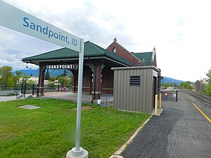
Sandpoint station is a train station along Amtrak's Empire Builder line in Sandpoint, Idaho, as well as the only operating Amtrak station in Idaho. The station site is owned by BNSF Railway. The station building is the oldest remaining active passenger depot of the former Northern Pacific Railway.
Sandpoint Airport
Airport
Distance: Approx. 2591 meters
Latitude and longitude: 48.29944444,-116.56
Sandpoint Airport (ICAO: KSZT, FAA LID: SZT) is a county-owned public-use airport in the northwest United States, located two nautical miles (4 km) north of the central business district of Sandpoint in Bonner County, Idaho. The airport is also known as Dave Wall Field. Although most U.S. airports use the same three-letter location identifier for the FAA and IATA, this airport is assigned SZT by the FAA but has no designation from the IATA (which assigned SZT to San Cristóbal de las Casas National Airport in Mexico).

Sandpoint Historic District
United States historic place
Distance: Approx. 465 meters
Latitude and longitude: 48.27555556,-116.54722222
The Sandpoint Historic District in Sandpoint, Idaho is a historic district which was listed on the National Register of Historic Places in 1984, and enlarged in 2018. When first listed, it consisted of 13 buildings on the block bound by 1st and 2nd Avenues, Main St., and Cedar St., plus two other buildings across from the block. It includes: W.A. Bernd Building (1907), 307-311 N. First Avenue, which was separately listed on the National Register in 1983.

Sandpoint Federal Building
United States historic place
Distance: Approx. 309 meters
Latitude and longitude: 48.27694444,-116.54916667
The Sandpoint Federal Building, at 419 N. Second Ave. in Sandpoint, Idaho, was built in 1928. It was listed on the National Register of Historic Places in 2001.

Amanda Nesbitt House
United States historic place
Distance: Approx. 239 meters
Latitude and longitude: 48.27833333,-116.55138889
The Amanda Nesbitt House, at 602 N. 4th Ave. in Sandpoint, Idaho, was built in 1906. It was listed on the National Register of Historic Places in 1982 as Dan Tanner House, and the official listing name was changed in 1987.
Weather in this IP's area
moderate rain
3 Celsius
3 Celsius
3 Celsius
4 Celsius
1009 hPa
80 %
1009 hPa
933 hPa
10000 meters
100 %
06:51:24
16:09:59
