Country:
Region:
City:
Latitude and Longitude:
Time Zone:
Postal Code:
IP information under different IP Channel
ip-api
Country
Region
City
ASN
Time Zone
ISP
Blacklist
Proxy
Latitude
Longitude
Postal
Route
Luminati
Country
ASN
Time Zone
America/Chicago
ISP
TVC-AS1
Latitude
Longitude
Postal
IPinfo
Country
Region
City
ASN
Time Zone
ISP
Blacklist
Proxy
Latitude
Longitude
Postal
Route
db-ip
Country
Region
City
ASN
Time Zone
ISP
Blacklist
Proxy
Latitude
Longitude
Postal
Route
ipdata
Country
Region
City
ASN
Time Zone
ISP
Blacklist
Proxy
Latitude
Longitude
Postal
Route
Popular places and events near this IP address

Upton, Maine
Town in the state of Maine, United States
Distance: Approx. 874 meters
Latitude and longitude: 44.69416667,-71.01055556
Upton is a town in Oxford County, Maine, United States. The population was 69 at the 2020 census. Totally.

Cambridge, New Hampshire
Township in Coos County, New Hampshire, United States
Distance: Approx. 8101 meters
Latitude and longitude: 44.65972222,-71.10861111
Cambridge is a township in Coös County in the state of New Hampshire. The population was 16 at the 2020 census, up from 8 at the 2010 census. In New Hampshire, locations, grants, townships (which are different from towns), and purchases are unincorporated portions of a county which are not part of any town and have limited self-government (if any, as many are uninhabited).

Umbagog Lake
Lake in New Hampshire and Maine, United States
Distance: Approx. 7029 meters
Latitude and longitude: 44.75694444,-71.04916667
Umbagog Lake is a wilderness lake located in Coös County, New Hampshire, and Oxford County, Maine. It is one of the most pristine lakes in the state of New Hampshire. It lies in the towns of Errol, New Hampshire, and Upton, Maine, as well as the townships of Cambridge, New Hampshire, and Magalloway, Maine.
Dead Cambridge River
River in the United States
Distance: Approx. 1742 meters
Latitude and longitude: 44.71255,-71.0173
The Dead Cambridge River is a 9.9-mile-long (15.9 km) river in northwestern Maine. It is a tributary of Lake Umbagog, the outflow of which is the Androscoggin River, flowing to the tidal Kennebec River and the Atlantic Ocean. The dead title is somewhat common on slow moving, flat rivers in the state of Maine.
Swift Cambridge River
River in Maine, United States
Distance: Approx. 3532 meters
Latitude and longitude: 44.71894,-70.98841
The Swift Cambridge River is a 15.3-mile-long (24.6 km) river in northwestern Maine. It rises near the New Hampshire border, north of Grafton Notch, and flows north to the Dead Cambridge River, a tributary of Umbagog Lake. The Androscoggin River flows from Umbagog to the tidal Kennebec River in Maine.

Forest Lodge (Upton, Maine)
United States historic place
Distance: Approx. 9543 meters
Latitude and longitude: 44.76666667,-70.95027778
Forest Lodge is a historic homestead in rural northern Oxford County, Maine. Lying in a hard-to-reach corner of Upton, on the northern bank of the Rapid River, it comprises seven buildings, four of which are residential. The complex was owned and occupied by the family of writer Louise Dickinson Rich (1903–1991) year round from 1933 to 1944, and as Rich's summer home until 1955.

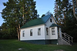
Former Upton Grange No. 404
United States historic place
Distance: Approx. 761 meters
Latitude and longitude: 44.69444444,-71.01194444
The Former Upton Grange No. 404 is a historic former Grange hall on Maine State Route 26 in rural Upton, Maine. Built in 1899, this now-vacant wood-frame building has seen a variety of commercial, civic and social uses.
Umbagog Lake State Park
Distance: Approx. 2806 meters
Latitude and longitude: 44.7023,-71.0555
Umbagog Lake State Park is a 1,360-acre (550 ha) park in Errol, New Hampshire, on the southern shore of Umbagog Lake along Route 26. It is adjacent to the Umbagog National Wildlife Refuge. Activities in the state park include swimming, camping, canoeing, fishing, hiking, wildlife watching, and picnicking.
Weather in this IP's area
scattered clouds
1 Celsius
-2 Celsius
0 Celsius
3 Celsius
1032 hPa
55 %
1032 hPa
969 hPa
10000 meters
2.57 m/s
300 degree
40 %
06:25:13
16:30:00