66.158.254.87 - IP Lookup: Free IP Address Lookup, Postal Code Lookup, IP Location Lookup, IP ASN, Public IP
Country:
Region:
City:
Location:
Time Zone:
Postal Code:
IP information under different IP Channel
ip-api
Country
Region
City
ASN
Time Zone
ISP
Blacklist
Proxy
Latitude
Longitude
Postal
Route
Luminati
Country
ASN
Time Zone
America/Chicago
Latitude
Longitude
Postal
IPinfo
Country
Region
City
ASN
Time Zone
ISP
Blacklist
Proxy
Latitude
Longitude
Postal
Route
IP2Location
66.158.254.87Country
Region
florida
City
orlando
Time Zone
America/New_York
ISP
Language
User-Agent
Latitude
Longitude
Postal
db-ip
Country
Region
City
ASN
Time Zone
ISP
Blacklist
Proxy
Latitude
Longitude
Postal
Route
ipdata
Country
Region
City
ASN
Time Zone
ISP
Blacklist
Proxy
Latitude
Longitude
Postal
Route
Popular places and events near this IP address

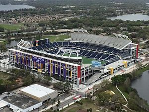
Camping World Stadium
Stadium in Florida, U.S.
Distance: Approx. 1121 meters
Latitude and longitude: 28.53888889,-81.40277778
Camping World Stadium is an outdoor stadium in Orlando, Florida, United States located in the West Lakes neighborhood of Downtown Orlando, west of new sports and entertainment facilities including the Kia Center, the Dr. Phillips Center for the Performing Arts, and Inter&Co Stadium. It opened in 1936 as Orlando Stadium and has also been known as the Tangerine Bowl and Florida Citrus Bowl.

Griffin Park Historic District
Historic district in Florida, United States
Distance: Approx. 2093 meters
Latitude and longitude: 28.53277778,-81.38611111
The Griffin Park Historic District is a U.S. historic district (designated as such on July 18, 1996) located in Orlando, Florida. The district is bounded by Avondale and South Division Avenues, Carter Street, and I-4. It contains 26 historic buildings.

Tinker Field
Baseball stadium in Orlando, Florida, U.S.
Distance: Approx. 1031 meters
Latitude and longitude: 28.53861111,-81.40477778
Tinker Field was an outdoor baseball stadium in Orlando, Florida, United States. Named after Baseball Hall of Fame inductee Joe Tinker, it was located in the West Lakes neighborhoods of Downtown Orlando. In April 2015, the City of Orlando tore down the grandstands and removed all other extant buildings, due to its proximity to renovation work on the Orlando Citrus Bowl football stadium (later renamed as Camping World Stadium).
Ajax Orlando Prospects
Football club
Distance: Approx. 1722 meters
Latitude and longitude: 28.518817,-81.419823
Ajax Orlando Prospects was an American soccer team, founded in 2002. The team was a member of the United Soccer Leagues Premier Development League (PDL), the fourth tier of the American Soccer Pyramid, until 2006, when the team left the league and the franchise was terminated. The Prospects played their home games at Warden Stadium on the grounds of The First Academy, a Christian college preparatory school in Orlando, Florida.
Jones High School (Orlando, Florida)
School in Orlando, Florida, United States
Distance: Approx. 701 meters
Latitude and longitude: 28.532999,-81.401163
Jones High School is located in the Parramore/Lorna Doone neighborhood in the urban heart of Orlando, Florida at 801 S. Rio Grande Avenue. It is a public school in the Orange County School District. The school mascot is the Tiger and the colors are orange and green.
Workforce Advantage Academy
Distance: Approx. 1308 meters
Latitude and longitude: 28.51847222,-81.40291667
Workforce Advantage Academy is a charter school in Orange County, Florida serving 11th and 12th graders with an academic and business internship program. Denis Tillman is the school's director of business development.

Inter&Co Stadium
Soccer stadium in Orlando
Distance: Approx. 2169 meters
Latitude and longitude: 28.5411,-81.3893
Inter&Co Stadium (formerly Orlando City Stadium and Exploria Stadium) is a soccer-specific stadium in downtown Orlando, Florida. The stadium is located along West Church Street in the Parramore neighborhood west of Downtown Orlando. It is the home of Orlando City SC, which entered Major League Soccer (MLS) as an expansion franchise in 2015, and National Women's Soccer League (NWSL) club, the Orlando Pride.

Holden–Parramore Historic District
Historic district in Florida, United States
Distance: Approx. 2207 meters
Latitude and longitude: 28.53833333,-81.38694444
The Holden–Parramore Historic District is a U.S. historic district located in Parramore neighborhood of west-central Orlando, Florida. The district is roughly bounded by W. Church Street, S. Division Avenue, Long Street, McFall Avenue, and S. Parramore Avenue. It was added to the National Register of Historic Places on September 23, 2009.
Parramore
Human settlement in Orlando, Florida, United States of America
Distance: Approx. 2046 meters
Latitude and longitude: 28.5385,-81.3889
Parramore is a neighborhood in west-central Orlando, Florida. It is a historical neighborhood for Orlando residents of African descent, and suffered greatly during the Jim Crow era. In 2015, the unemployment rate was reported as 23.8% and median household income was $15,493.
Lake Lorna Doone Park
Distance: Approx. 1443 meters
Latitude and longitude: 28.5411,-81.4004
Lake Lorna Doone Park is a 12 acre park located in the between the neighborhoods of Westfield and Parramore in Orlando, Florida. The physical address is 1519 West Church Street, just to the north of Camping World Stadium. After undergoing an $8 million dollar renovation in 2021, Lake Lorna Doone Park is now the "Jewel of the West Side".
Clear Lake (Orlando, Florida)
Lake in the state of Florida, United States
Distance: Approx. 909 meters
Latitude and longitude: 28.5219,-81.4103
Clear Lake is a 357-acre (1,440,000 m2) freshwater lake located in central Orlando, Florida. This lake, somewhat lemon shaped, is surrounded by a residential area. A series of canals on the lake's southwest provide boat access for the houses there.
Sunset Lake (Orlando, Florida)
Lake in the state of Florida, United States
Distance: Approx. 871 meters
Latitude and longitude: 28.5365,-81.4114
Sunset Lake, sometimes called Lake Sunset, is a 28.76-acre (116,400 m2) freshwater lake located in west central Orlando, Florida, United States. This teardrop-shaped lake is surrounded by a residential area. John Young Parkway borders the lake on part of its west side.
Weather in this IP's area
overcast clouds
16 Celsius
16 Celsius
14 Celsius
16 Celsius
1025 hPa
92 %
1025 hPa
1021 hPa
10000 meters
4.63 m/s
20 degree
100 %