Country:
 USA
USARegion:
City:
Latitude and Longitude:
Time Zone:
Postal Code:
IP information under different IP Channel
ip-api
Country
Region
City
ASN
Time Zone
ISP
Blacklist
Proxy
Latitude
Longitude
Postal
Route
IPinfo
Country
Region
City
ASN
Time Zone
ISP
Blacklist
Proxy
Latitude
Longitude
Postal
Route
MaxMind
Country
Region
City
ASN
Time Zone
ISP
Blacklist
Proxy
Latitude
Longitude
Postal
Route
Luminati
Country
USASN
Time Zone
America/Chicago
ISP
INTERNAP-2BLK
Latitude
Longitude
Postal
db-ip
Country
Region
City
ASN
Time Zone
ISP
Blacklist
Proxy
Latitude
Longitude
Postal
Route
ipdata
Country
Region
City
ASN
Time Zone
ISP
Blacklist
Proxy
Latitude
Longitude
Postal
Route
Popular places and events near this IP address
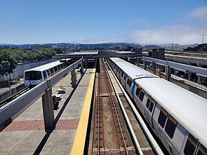
Daly City station
Rapid transit station in California, US
Distance: Approx. 613 meters
Latitude and longitude: 37.706224,-122.468934
Daly City station is an elevated Bay Area Rapid Transit (BART) station in Daly City, California, just south of the city limits of San Francisco. It is adjacent to Interstate 280 and California Route 1, which it serves as a park-and-ride station. The station is served by the Red, Yellow, Green, and Blue lines; it is the western terminus of the Green and Blue lines.

Jefferson High School (Daly City, California)
Public high school in Daly City, California, United States
Distance: Approx. 1176 meters
Latitude and longitude: 37.6957,-122.4659
Jefferson High School is an American public high school in Daly City, California, United States, and was the first school in the Jefferson Union High School District (JUHSD). Jefferson serves Daly City, Brisbane, Pacifica, and Colma.

Outer Mission, San Francisco
Neighborhood of San Francisco
Distance: Approx. 1127 meters
Latitude and longitude: 37.71111111,-122.45111111
Outer Mission is a small residential neighborhood on the south edge of San Francisco, bounded by Geneva Avenue (on the northeast), Interstate 280 (on the northwest), Mission Street (on the southwest), and the city of Daly City (on the south). It is bordered by the Mission Terrace, Crocker-Amazon, and Ingleside, and touches Excelsior (at the corner of Mission Street and Geneva Avenue). The Muni streetcar historic "car barn" is at the northern corner of this neighborhood.
Oceanview, San Francisco
Neighborhood in San Francisco, California, United States
Distance: Approx. 1065 meters
Latitude and longitude: 37.7144,-122.4567
Oceanview is a neighborhood in the southern portion of San Francisco, California. It was first established as a community in the 1910s and originally centered on the intersection of Sagamore Street and San Jose Avenue. Today, the neighborhood is bordered by Orizaba Avenue to the west, Lakeview Avenue to the north, and Interstate 280 to the south and east.

Cayuga Park
Distance: Approx. 1370 meters
Latitude and longitude: 37.71388889,-122.45027778
Cayuga Park is a neighborhood park and playground in San Francisco, at the edge of the Cayuga Terrace neighborhood. Its history, location and aesthetics make it unique among the parks of San Francisco.

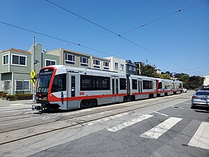
19th Avenue and Randolph station
Distance: Approx. 1164 meters
Latitude and longitude: 37.71425,-122.46978
19th Avenue and Randolph station is a light rail stop on the Muni Metro M Ocean View line, located in the Ingleside neighborhood of San Francisco, California. The stop has no platforms; trains stop at marked poles before crossing Randolph Street and passengers cross a parking lane on 19th Avenue to board trains. The stop is not accessible.

Randolph and Arch station
Distance: Approx. 1043 meters
Latitude and longitude: 37.71426,-122.4671
Randolph and Arch is a light rail stop on the Muni Metro M Ocean View line, located in the Ingleside Heights neighborhood of San Francisco, California. The stop has no regular platforms; passengers cross a parking lane to board trains. Mini-high platforms for accessibility are located on the far side of Arch Street.
Randolph and Bright station
Distance: Approx. 954 meters
Latitude and longitude: 37.71429,-122.46351
Randolph and Bright station is a light rail stop on the Muni Metro M Ocean View line, located in the Ingleside neighborhood of San Francisco, California. The stop has no platforms; trains stop at marked poles before crossing Bright Street and passengers cross a parking lane on Randolph Street to board trains. The stop is not accessible.

Broad and Orizaba / Orizaba and Broad stations
Pair of light rail stops in San Francisco
Distance: Approx. 821 meters
Latitude and longitude: 37.71316,-122.46259
Broad and Orizaba / Orizaba and Broad stations are a pair of light rail stops on the Muni Metro M Ocean View line, located in the Ingleside neighborhood of San Francisco, California. The inbound stop is located on Broad Street at Orizaba Avenue, while outbound trains stop on Orizaba Avenue at Broad Street. The stop has no platforms; trains stop at marked poles and passengers cross a vehicle travel lane to board or depart trains.

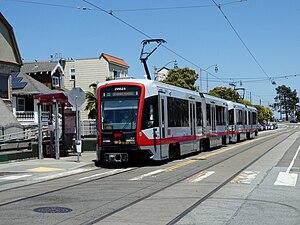
Broad and Capitol station
Distance: Approx. 863 meters
Latitude and longitude: 37.71319,-122.45904
Broad and Capitol station is a light rail stop on the Muni Metro M Ocean View line, located in the Ingleside neighborhood of San Francisco, California. The stop has no platforms; trains stop at marked poles before crossing Capitol Avenue and passengers cross a vehicle travel lane on Broad Street to board trains. The stop is not accessible.
Broad and Plymouth station
Light rail stop in San Francisco, California, US
Distance: Approx. 973 meters
Latitude and longitude: 37.71318,-122.45608
Broad and Plymouth station is a light rail stop on the Muni Metro M Ocean View line, located in the Ingleside neighborhood of San Francisco, California. The station has transit bulbs which extend the sidewalk of Broad Street, to meet trains like a side platform, allowing passengers to board or depart from trains. The stops are located just before trains cross Plymouth Avenue and include accessible mini-high platforms.

San Jose and Farallones station
Distance: Approx. 1268 meters
Latitude and longitude: 37.71412,-122.45216
San Jose and Farallones station is a light rail stop on the Muni Metro M Ocean View line, located in the Oceanview neighborhood of San Francisco, California. The station has two side platforms (traffic islands) in the middle of San Jose Avenue. The platforms are not accessible.
Weather in this IP's area
broken clouds
20 Celsius
19 Celsius
17 Celsius
23 Celsius
1017 hPa
35 %
1017 hPa
1004 hPa
10000 meters
6.17 m/s
290 degree
75 %
07:21:25
18:28:00