Country:
 USA
USARegion:
City:
Latitude and Longitude:
Time Zone:
Postal Code:
IP information under different IP Channel
ip-api
Country
Region
City
ASN
Time Zone
ISP
Blacklist
Proxy
Latitude
Longitude
Postal
Route
IPinfo
Country
Region
City
ASN
Time Zone
ISP
Blacklist
Proxy
Latitude
Longitude
Postal
Route
MaxMind
Country
Region
City
ASN
Time Zone
ISP
Blacklist
Proxy
Latitude
Longitude
Postal
Route
Luminati
Country
USASN
Time Zone
America/Chicago
ISP
INTERNAP-2BLK
Latitude
Longitude
Postal
db-ip
Country
Region
City
ASN
Time Zone
ISP
Blacklist
Proxy
Latitude
Longitude
Postal
Route
ipdata
Country
Region
City
ASN
Time Zone
ISP
Blacklist
Proxy
Latitude
Longitude
Postal
Route
Popular places and events near this IP address
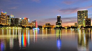
Orlando, Florida
City in Florida, United States
Distance: Approx. 208 meters
Latitude and longitude: 28.54,-81.38
Orlando ( or-LAN-doh) is a city in and the county seat of Orange County, Florida, United States. Part of Central Florida, it is the center of the Orlando metropolitan area, which had a population of 2,509,831 in 2017, according to the U.S. Census Bureau. It is the sixth-largest metropolitan area in the Southern United States and the third-largest metropolitan area in Florida behind Miami and Tampa Bay.
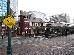
Church Street Station
Historic train station in downtown Orlando, Florida
Distance: Approx. 241 meters
Latitude and longitude: 28.54,-81.38055556
Church Street Station, also called the Old Orlando Railroad Depot, is a historic train station and commercial development in Orlando, Florida. The historic depot and surrounding buildings house a retail and entertainment center. The complex also contains a stop for SunRail, the commuter rail service of the Greater Orlando area.

Greater Orlando
Metropolitan statistical area in Florida, United States
Distance: Approx. 208 meters
Latitude and longitude: 28.54,-81.38
The Orlando metropolitan area (officially, for U.S. Census purposes, the Orlando–Kissimmee–Sanford, Florida Metropolitan Statistical Area) is an inland metropolitan area in the central region of the U.S. state of Florida. Its principal cities are Orlando, Kissimmee and Sanford. The U.S. Office of Management and Budget defines it as consisting of the counties of Lake, Orange (including Orlando), Osceola, and Seminole.
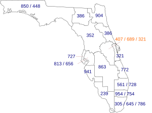
Area codes 407 and 689
Area codes for Orlando, Florida
Distance: Approx. 208 meters
Latitude and longitude: 28.54,-81.38
Area codes 407 and 689 are telephone area codes in the North American Numbering Plan (NANP) for the city of Orlando and surrounding areas in the U.S. state of Florida. The numbering plan area (NPA) includes Orange, Osceola and Seminole counties, as well as small portions of Volusia and Lake counties. Area code 407 was created in 1988 in a split of area code 305, Florida's original area code of 1947.

Dr. Phillips Center for the Performing Arts
Distance: Approx. 80 meters
Latitude and longitude: 28.538032,-81.378192
Dr. Phillips Center for the Performing Arts (commonly known as Dr. Phillips Center) is a performing arts center in Downtown Orlando, Florida, United States.

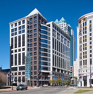
200 South Orange
American skyscraper located in the Central Business District of Orlando, Florida
Distance: Approx. 184 meters
Latitude and longitude: 28.5398,-81.3799
200 South Orange, formerly known as the SunTrust Center and Sun Bank Center, is a skyscraper located in the Central Business District of Orlando, Florida. Rising to 441 ft (134.4 m), it is the tallest multi-story building in Orlando and Central Florida outside of Tampa and St. Petersburg.

CNL Center City Commons
Complex of buildings in Downtown Orlando
Distance: Approx. 134 meters
Latitude and longitude: 28.53722222,-81.37916667
CNL Center City Commons is a complex of buildings in Downtown Orlando. The main building is a 250 foot tall skyscraper that is the headquarters of CNLBank, Alliance Bankshares before being acquired by the founder of CNL Financial Group. In 2010, its assessed value was $59.6 million.

First United Methodist Church of Orlando
Distance: Approx. 195 meters
Latitude and longitude: 28.53886,-81.37698
First United Methodist Church of Orlando is a church located in Downtown Orlando. Founded in 1882, First United Methodist Church has been a presence in Central Florida for over 125 years. The church has helped found many non-profit and charitable organizations, including the Coalition for the Homeless and IDignity.

Orlando City Hall
Distance: Approx. 113 meters
Latitude and longitude: 28.53759,-81.379596
Orlando City Hall is the headquarters of the City of Orlando government. The downtown city hall is a 9 floor, postmodern building constructed by Lincoln Property Company and completed in 1992. The building is located in downtown Orlando at the CNL Center City Commons building complex, on the corner of South Orange Avenue and South Street.
Lincoln Plaza at SunTrust Center
Distance: Approx. 63 meters
Latitude and longitude: 28.53877,-81.379384
Lincoln Plaza at SunTrust Center is a 16-story office building in downtown Orlando, Florida. The building was completed in 2000 at a cost of $43 million. Construction on the building began in April 1999.

Citrus Center
Commercial office building in Orlando, Florida
Distance: Approx. 111 meters
Latitude and longitude: 28.5393,-81.3784
The Citrus Center, also known as the BB&T building, originally known as the CNA Tower, is a commercial office building in Orlando, Florida, United States located at 255 South Orange Avenue. Topped out in December 1970 and completed in April 1971, it was the first modern skyscraper in Orlando. It is 281 feet (85.65 metres) and 19 storeys tall, the first five storeys of which are a parking structure (four totally enclosed and the fifth open save for parapet walls,) with an entrance lobby and some tenants on the first floor.

American Federal Building
Distance: Approx. 133 meters
Latitude and longitude: 28.537357,-81.37823
The American Federal Building, also known as the American Federal Savings and Loan Building, the Coral Gables Building, and the Round Building, was an iconic seven-story office building in downtown Orlando, Florida. The bottom two floors, encircled with a cast concrete brise soleil comprise the original building, were completed in 1963. The building's unique architecture and history have inspired efforts to preserve it from demolition.
Weather in this IP's area
clear sky
25 Celsius
26 Celsius
24 Celsius
25 Celsius
1013 hPa
96 %
1013 hPa
1009 hPa
10000 meters
1.54 m/s
150 degree
07:07:31
19:38:53