Country:
 USA
USARegion:
City:
Latitude and Longitude:
Time Zone:
Postal Code:
IP information under different IP Channel
ip-api
Country
Region
City
ASN
Time Zone
ISP
Blacklist
Proxy
Latitude
Longitude
Postal
Route
IPinfo
Country
Region
City
ASN
Time Zone
ISP
Blacklist
Proxy
Latitude
Longitude
Postal
Route
MaxMind
Country
Region
City
ASN
Time Zone
ISP
Blacklist
Proxy
Latitude
Longitude
Postal
Route
Luminati
Country
USRegion
ct
City
wilton
ASN
Time Zone
America/New_York
ISP
INTERNAP-BLK3
Latitude
Longitude
Postal
db-ip
Country
Region
City
ASN
Time Zone
ISP
Blacklist
Proxy
Latitude
Longitude
Postal
Route
ipdata
Country
Region
City
ASN
Time Zone
ISP
Blacklist
Proxy
Latitude
Longitude
Postal
Route
Popular places and events near this IP address
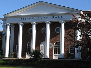
Wilton, Connecticut
Town in Connecticut, United States
Distance: Approx. 88 meters
Latitude and longitude: 41.2,-73.43333333
Wilton is a town in Fairfield County, Connecticut, United States. As of the 2020 census, the town population was 18,503. The town is part of the Western Connecticut Planning Region.

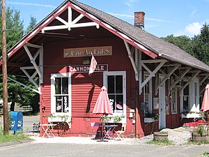
Cannondale station
Metro-North Railroad station in Connecticut
Distance: Approx. 1994 meters
Latitude and longitude: 41.21666667,-73.42666667
Cannondale station is a commuter rail station on the Danbury Branch of the Metro-North Railroad's New Haven Line, located in the Cannondale neighborhood of Wilton, Connecticut. The station building was added to the National Register of Historic Places in 1992 as part of the Cannondale Historic District.
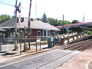
Wilton station (Metro-North)
Metro-North Railroad station in Connecticut
Distance: Approx. 461 meters
Latitude and longitude: 41.1959,-73.4321
Wilton station is a commuter rail station on the Danbury Branch of the Metro-North Railroad's New Haven Line, located in Wilton, Connecticut. The station first opened in 1852 and is the most used station on the Danbury Branch by weekday passengers.

Wilton High School
Public high school in Wilton, Connecticut, United States
Distance: Approx. 1240 meters
Latitude and longitude: 41.2108,-73.433
Wilton High School is a public high school in Wilton, Connecticut, U.S., considered "one of Connecticut's top performers" in various measures of school success in 2007, including scores on standardized mathematics and reading tests. In 2016, U.S. News & World Report ranked Wilton as the 7th best public high school in Connecticut and 386th in the United States. The school's present, permanent location did not open until 1971.
Cannondale, Connecticut
Census-designated place in Connecticut, United States
Distance: Approx. 2006 meters
Latitude and longitude: 41.21638889,-73.42527778
Cannondale is a census-designated place (CDP) within the town of Wilton in Fairfield County, Connecticut. It had a population of 141 at the 2010 census. The neighborhood consists of many old homes on large, almost rural lots now largely wooded.

Wilton Center Historic District
Historic district in Connecticut, United States
Distance: Approx. 625 meters
Latitude and longitude: 41.19527778,-73.43888889
The Wilton Center Historic District in the town center area of Wilton, Connecticut, was established as a town historic district in 1970 and was listed on the National Register of Historic Places in 1992. Wilton's town center was formed in 1726 when the first meetinghouse was built. That meetinghouse was replaced with a new building in 1738, and finally in 1790 by a third church, the current Congregational Church at 70 Ridgefield Road.

Wilton Center, Connecticut
Census-designated place in Connecticut, United States
Distance: Approx. 1067 meters
Latitude and longitude: 41.19027778,-73.43194444
Wilton Center is a neighborhood/section and census-designated place (CDP) in the town of Wilton in Fairfield County, Connecticut, United States. As of the 2010 census it had a population of 732. The CDP partially overlaps the Wilton Center Historic District.

Hurlbutt Street School
United States historic place
Distance: Approx. 2091 meters
Latitude and longitude: 41.2011,-73.4094
The Hurlbutt Street School is a historic one-room schoolhouse at 157 Hurlbutt Street in Wilton, Connecticut. Built in 1834, it served the town as a school for nearly a century, and was then converted into a local history museum. It is the town's best-preserved 19th-century district school building, and was listed on the National Register of Historic Places in 1996.

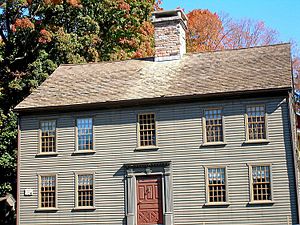
Marvin Tavern
Historic tavern in Connecticut, United States
Distance: Approx. 1338 meters
Latitude and longitude: 41.21166667,-73.43277778
The Marvin Tavern, also known as Matthew Marvin House, is a historic house located at 405 Danbury Road in Wilton, Connecticut, Located adjacent to Wilton High School. It is a 2+1⁄2-story wood-frame structure, with a hip roof and a large central chimney. Although it was built c.
Sloan-Raymond-Fitch House
Historic house in Connecticut, United States
Distance: Approx. 1462 meters
Latitude and longitude: 41.18833333,-73.42555556
The Sloan-Raymond-Fitch House is a historic house at 224 Danbury Road in Wilton, Connecticut. It is a 2+1⁄2-story wood-frame structure, five bays wide, with a side-gable roof and a large central chimney. A smaller two-story ell extends to the rear.
Grange Hall (Wilton, Connecticut)
United States historic place
Distance: Approx. 1945 meters
Latitude and longitude: 41.2161,-73.4263
The Grange Hall in the Cannondale section of the town of Wilton, Connecticut is a historic Grange building, and is home of the Cannon Grange. The building was built in 1899 as a community center. It was acquired by the Grange organization in 1933.

First Congregational Church of Guilford
Distance: Approx. 2120 meters
Latitude and longitude: 41.19869444,-73.40902778
First Congregational Church of Guilford is a United Church of Christ congregation in Guilford, Connecticut. The church was founded in 1643, just a few years after the first settlement of Guilford in 1639. At that time, under the theocratic structure of the New Haven Colony, the town of Guilford and its church were essentially the same entity.
Weather in this IP's area
light rain
17 Celsius
17 Celsius
16 Celsius
18 Celsius
1009 hPa
95 %
1009 hPa
999 hPa
10000 meters
2.06 m/s
260 degree
100 %
06:57:01
18:25:31