Country:
 USA
USARegion:
City:
Latitude and Longitude:
Time Zone:
Postal Code:
IP information under different IP Channel
ip-api
Country
Region
City
ASN
Time Zone
ISP
Blacklist
Proxy
Latitude
Longitude
Postal
Route
IPinfo
Country
Region
City
ASN
Time Zone
ISP
Blacklist
Proxy
Latitude
Longitude
Postal
Route
MaxMind
Country
Region
City
ASN
Time Zone
ISP
Blacklist
Proxy
Latitude
Longitude
Postal
Route
Luminati
Country
USRegion
ga
City
flowerybranch
ASN
Time Zone
America/New_York
ISP
INTERNAP-BLOCK-4
Latitude
Longitude
Postal
db-ip
Country
Region
City
ASN
Time Zone
ISP
Blacklist
Proxy
Latitude
Longitude
Postal
Route
ipdata
Country
Region
City
ASN
Time Zone
ISP
Blacklist
Proxy
Latitude
Longitude
Postal
Route
Popular places and events near this IP address

Rest Haven, Georgia
Town in Georgia, United States
Distance: Approx. 8627 meters
Latitude and longitude: 34.13305556,-83.97666667
Rest Haven is a town primarily in northern Gwinnett and partly in southern Hall counties in the U.S. state of Georgia. As of 2020, its population was 45. Rest Haven is located along Georgia State Route 13, a highway from Atlanta to Gainesville that is immediately west of Interstate 985.

Flowery Branch, Georgia
City in Georgia, United States
Distance: Approx. 962 meters
Latitude and longitude: 34.17638889,-83.91138889
Flowery Branch is a city in Hall County, Georgia, United States. As of the 2020 census, the city had a population of 9,391. It is part of the Gainesville, Georgia metropolitan area, and lies on the shores of Lake Lanier.

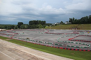
Road Atlanta
Race track
Distance: Approx. 8538 meters
Latitude and longitude: 34.14666667,-83.81777778
Road Atlanta (known for sponsorship reasons as Michelin Raceway Road Atlanta) is a 2.540 mi (4.088 km) road course located just north of Braselton, Georgia, United States. The facility is utilized for a wide variety of events, including professional and amateur sports car and motorcycle races, racing and driving schools, corporate programs and testing for motorsports teams. The track has 12 turns, including the famous "esses" between turns three and five; and Turn 12, a downhill, diving turn.

Lake Lanier
Reservoir in Georgia, United States
Distance: Approx. 8085 meters
Latitude and longitude: 34.24,-83.95
Lake Lanier (officially Lake Sidney Lanier) is a reservoir in the northern portion of the U.S. state of Georgia. It was created by the completion of Buford Dam on the Chattahoochee River in 1956, and is also fed by the waters of the Chestatee River. The lake encompasses 38,000 acres (15,000 ha) or 59 sq mi (150 km2) of water, and 692 mi (1,114 km) of shoreline at normal level, a "full pool" of 1,071 ft (326 m) above mean sea level and the exact shoreline varies by resolution according to the coastline paradox.
Flowery Branch High School
Public school in Flowery Branch, Georgia, United States
Distance: Approx. 702 meters
Latitude and longitude: 34.1857,-83.9018
Flowery Branch High School is a four-year public high school located in Flowery Branch, Georgia, United States, operated by Hall County Schools. In 2007, Flowery Branch was voted Georgia's High School of Excellence. It is one of seven high schools in the district and enrolls about 1,600 students.
West Hall High School
Public school in Georgia, United States
Distance: Approx. 4363 meters
Latitude and longitude: 34.217864,-83.910722
West Hall High School is a public high school located in the western portion of Hall County, Georgia, United States, in the foothills of the Appalachian Mountains. West Hall is located about 10 miles southwest of Gainesville City, 20 miles Southwest of Dahlonega, and around 40 miles northeast of Downtown Atlanta. The attendance boundary includes portions of Flowery Branch.
Johnson High School (Gainesville, Georgia)
Public school in Gainesville, Georgia, United States
Distance: Approx. 6712 meters
Latitude and longitude: 34.224828,-83.853666
Robert Wood Johnson High School is a public high school located in Gainesville, Georgia, United States, operated by the Hall County School District. The school serves 1,600 students in grades 9 to 12.
Caffeine and Octane's Lanier Raceway
Racetrack in the United States
Distance: Approx. 8705 meters
Latitude and longitude: 34.15333333,-83.8125
Caffeine and Octane's Lanier Raceway (formerly Lanier Raceplex and Lanier National Speedway) is a 0.375-mile paved oval racetrack located just outside Braselton, Georgia. The track opened in 1982 as a dirt track, and was paved in the mid-1980s. It is currently owned and operated by High Octane, LLC, an auto events & multimedia business conglomerate.

W243CE
Radio station in Winder, Georgia
Distance: Approx. 7170 meters
Latitude and longitude: 34.12555556,-83.85888889
W243CE (96.5 FM "La Mega 96.5 y 105.1"), is a Spanish-language music radio station having Winder, Georgia as its city of license, and previously transmitting from west-northwest of Winder, about halfway to Auburn, Georgia. In late February 2016, it was granted a construction permit to move all the way southwest to Columbus, Georgia, in the far west-central part of the state, to become the FM side of WOKS AM 1340, with 250 watts ERP on 97.5, at about 53 m (174 ft) in height. Ordinarily prohibited, the long-distance move is allowed under the FCC's "AM revitalization" program, which allows AM stations (but not other low-power community stations like LPFM) to take existing FM translators and the service they provide away from their current areas and use them to duplicate their own service in the same area they already serve.
Gainesville State College
Former college in Georgia, U.S.
Distance: Approx. 6935 meters
Latitude and longitude: 34.23481389,-83.86718333
Gainesville State College was a state college of the University System of Georgia serving northeast Georgia. The Gainesville State College Gainesville Campus, located 45 miles (72 km) northeast of Atlanta and six miles (9.7 km) southwest of downtown Gainesville in Oakwood, was on Georgia State Route 53 less than a mile from I-985 exit 16. The Gainesville State College Oconee Campus was located on Bishop Farms Parkway in Watkinsville, Georgia.
Chestnut Mountain, Georgia
Unincorporated community in Georgia, United States
Distance: Approx. 5902 meters
Latitude and longitude: 34.1725,-83.83805556
Chestnut Mountain is an unincorporated community in Hall County, Georgia, United States. The community is located along Georgia State Route 53, 8.7 miles (14.0 km) south of Gainesville. The community was named after J. T. Chestnut, a pioneer citizen.
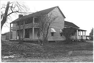
Bowman-Pirkle House
United States historic place
Distance: Approx. 6369 meters
Latitude and longitude: 34.1425,-83.95444444
The Bowman-Pirkle House is a historic two-story log house in Buford, Georgia. It was built in 1818 for John Bowman, who served under General Andrew Jackson during the First Seminole War of 1816–1819. The house was built with the help of Cherokees as a token of the friendship between Bowman and Chief Major Ridge.
Weather in this IP's area
clear sky
26 Celsius
26 Celsius
24 Celsius
28 Celsius
1010 hPa
56 %
1010 hPa
969 hPa
10000 meters
1.79 m/s
3.58 m/s
267 degree
1 %
07:34:47
19:11:29