Country:
 USA
USARegion:
City:
Latitude and Longitude:
Time Zone:
Postal Code:
IP information under different IP Channel
ip-api
Country
Region
City
ASN
Time Zone
ISP
Blacklist
Proxy
Latitude
Longitude
Postal
Route
IPinfo
Country
Region
City
ASN
Time Zone
ISP
Blacklist
Proxy
Latitude
Longitude
Postal
Route
MaxMind
Country
Region
City
ASN
Time Zone
ISP
Blacklist
Proxy
Latitude
Longitude
Postal
Route
Luminati
Country
USASN
Time Zone
America/Chicago
ISP
INTERNAP-BLK3
Latitude
Longitude
Postal
db-ip
Country
Region
City
ASN
Time Zone
ISP
Blacklist
Proxy
Latitude
Longitude
Postal
Route
ipdata
Country
Region
City
ASN
Time Zone
ISP
Blacklist
Proxy
Latitude
Longitude
Postal
Route
Popular places and events near this IP address
Langhorne, Pennsylvania
Borough in Pennsylvania, United States
Distance: Approx. 1455 meters
Latitude and longitude: 40.1775,-74.91888889
Langhorne Borough is a borough in Bucks County, Pennsylvania, United States. The population was 1,622 at the time of the 2010 census. The mailing address "Langhorne" is used for Langhorne Borough, but it is also used broadly to describe the majority of surrounding Middletown Township, which for the most part uses Langhorne's ZIP code of 19047.

Langhorne Manor, Pennsylvania
Borough in Pennsylvania, United States
Distance: Approx. 2065 meters
Latitude and longitude: 40.16583333,-74.91777778
Langhorne Manor is a borough in Bucks County, Pennsylvania, United States. The population was 1,422 at the 2010 census, a 55.6% increase from the 2000 census. The mayor of Langhorne Manor is Bob Byrne.

Middletown Township, Bucks County, Pennsylvania
Place in Pennsylvania, United States
Distance: Approx. 2033 meters
Latitude and longitude: 40.1625,-74.89527778
Middletown Township is a township in Bucks County, Pennsylvania, United States. The population was 46,040 at the 2020 census. Many sections of Levittown are located in the southern end of the township.

Oxford Valley Mall
Shopping mall in Langhorne, Pennsylvania
Distance: Approx. 1871 meters
Latitude and longitude: 40.1839,-74.8807
The Oxford Valley Mall is a two-story shopping mall, managed and 85.5 percent-owned by the Simon Property Group, that is located next to the Sesame Place amusement park near Langhorne in Middletown Township, Bucks County, Pennsylvania. Its department stores are JCPenney and Macy's. With 130 stores, Oxford Valley Mall is currently the tenth-largest shopping mall in Pennsylvania.

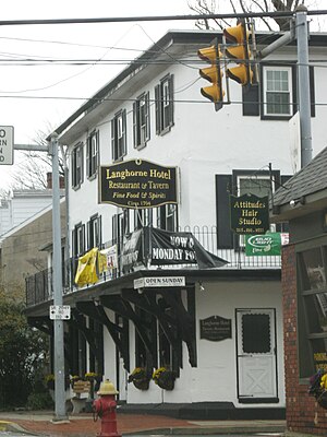
Langhorne Speedway
American auto racing venue
Distance: Approx. 1501 meters
Latitude and longitude: 40.178224,-74.884602
Langhorne Speedway was an automobile racetrack in Middletown Township, Bucks County, near the borough of Langhorne, Pennsylvania, a northern suburb of Philadelphia. According to the book Langhorne! No Man's Land by L. Spencer Riggs: "With all other courses up to that time being fairground horse tracks, Langhorne was the first [one-]mile dirt track built specifically for cars".

Woodbourne station
Distance: Approx. 1537 meters
Latitude and longitude: 40.1909,-74.891
Woodbourne station is a train station located on Woodbourne Road in Middletown Township, Pennsylvania along the SEPTA West Trenton Line which terminates at West Trenton station in Ewing, New Jersey, and also on the CSX Trenton Subdivision which has a freight yard not far by the station. In FY 2013, Woodbourne station had a weekday average of 702 boardings and 661 alightings.
Cairn University
Private Christian university in Pennsylvania
Distance: Approx. 1610 meters
Latitude and longitude: 40.1665,-74.9089
Cairn University is a private Christian university in Langhorne Manor and Middletown Township, Pennsylvania. Founded in 1913, the university has six schools and departments: Business, Counseling, Divinity, Education, Liberal Arts & Sciences, and Music. All students take a minimum of 30 semester hours of Bible classes.
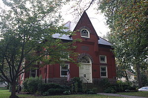
Langhorne Library
United States historic place
Distance: Approx. 1881 meters
Latitude and longitude: 40.17527778,-74.92333333
The Langhorne Library is an historic, American library building that is located in Langhorne, Bucks County, Pennsylvania. It was added to the National Register of Historic Places in 1986, is located in the Langhorne Historic District, which was added to the register in 1987.

Joseph Richardson House (Langhorne, Pennsylvania)
Historic house in Pennsylvania, United States
Distance: Approx. 1592 meters
Latitude and longitude: 40.17583333,-74.92
The Joseph Richardson House, also known as the Langhorne Community Memorial Building, is an historic American home that is located in Langhorne, Bucks County, Pennsylvania. Located in the Langhorne Historic District, it was added to the National Register of Historic Places in 1985.

Tomlinson-Huddleston House
Historic house in Pennsylvania, United States
Distance: Approx. 1697 meters
Latitude and longitude: 40.17611111,-74.92138889
The Tomlinson-Huddleston House, also known as The Signature House, is an historic, American home that is located in Langhorne, Bucks County, Pennsylvania. Now part of the Langhorne Historic District, it was added to the National Register of Historic Places in 1983.
Harewood and Beechwood
Historic house in Pennsylvania, United States
Distance: Approx. 898 meters
Latitude and longitude: 40.17861111,-74.9125
Harewood and Beechwood, also known as Woods School, are two historic homes which are located roughly four miles apart in Middletown Township, Bucks County, Pennsylvania. The school was added to the National Register of Historic Places in 1980.

Langhorne Historic District
Historic district in Pennsylvania, United States
Distance: Approx. 1682 meters
Latitude and longitude: 40.17583333,-74.92111111
The Langhorne Historic District, also known as "Attleborough," is a national historic district that is located in Langhorne, Bucks County, Pennsylvania. It was added to the National Register of Historic Places in 1986.
Weather in this IP's area
scattered clouds
22 Celsius
22 Celsius
21 Celsius
24 Celsius
1010 hPa
58 %
1010 hPa
1005 hPa
10000 meters
2.57 m/s
7.2 m/s
290 degree
40 %
07:02:15
18:32:02