Country:
 USA
USARegion:
City:
Latitude and Longitude:
Time Zone:
Postal Code:
IP information under different IP Channel
ip-api
Country
Region
City
ASN
Time Zone
ISP
Blacklist
Proxy
Latitude
Longitude
Postal
Route
IPinfo
Country
Region
City
ASN
Time Zone
ISP
Blacklist
Proxy
Latitude
Longitude
Postal
Route
MaxMind
Country
Region
City
ASN
Time Zone
ISP
Blacklist
Proxy
Latitude
Longitude
Postal
Route
Luminati
Country
USASN
Time Zone
America/Chicago
ISP
INTERNAP-BLK
Latitude
Longitude
Postal
db-ip
Country
Region
City
ASN
Time Zone
ISP
Blacklist
Proxy
Latitude
Longitude
Postal
Route
ipdata
Country
Region
City
ASN
Time Zone
ISP
Blacklist
Proxy
Latitude
Longitude
Postal
Route
Popular places and events near this IP address

Ladera Heights, California
Unincorporated community in Los Angeles County, California, US
Distance: Approx. 1406 meters
Latitude and longitude: 33.98888889,-118.37416667
Ladera Heights is a community and unincorporated area in Los Angeles County, California. The population was 6,634 at the 2020 census. Culver City lies to its west, the Baldwin Hills neighborhood to its north, the View Park-Windsor Hills community to its east, the Westchester neighborhood to its south and southwest and the city of Inglewood to its southeast.
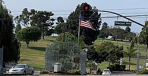
Holy Cross Cemetery, Culver City
Cemetery in Culver City, California, US
Distance: Approx. 1449 meters
Latitude and longitude: 33.99666667,-118.38
Holy Cross Cemetery is a Catholic cemetery at 5835 West Slauson Avenue in Culver City, California, operated by the Los Angeles Archdiocese. It is partially in the Culver City city limits. Opened in 1939, Holy Cross comprises 200 acres (81 ha).

Hillside Memorial Park Cemetery
Jewish cemetery in Culver City, California, United States
Distance: Approx. 610 meters
Latitude and longitude: 33.98055556,-118.38972222
The Hillside Memorial Park and Mortuary is a Jewish cemetery in Culver City, California, United States. Many Jewish people from the entertainment industry are buried there. The cemetery is known for Al Jolson's elaborate tomb (designed by Los Angeles architect Paul Williams), a 75-foot-high pergola and monument atop a hill above a water cascade, all visible from the adjacent San Diego Freeway.

Reason Foundation
American libertarian think tank
Distance: Approx. 990 meters
Latitude and longitude: 33.9842,-118.3995
The Reason Foundation is an American libertarian think tank that was founded in 1978. The foundation publishes the magazine Reason. Based in Los Angeles, California, it is a nonprofit, tax-exempt organization.

Institute for Creative Technologies
Research institute of the University of Southern California
Distance: Approx. 1433 meters
Latitude and longitude: 33.983264,-118.404168
The Institute for Creative Technologies (ICT) is a University Affiliated Research Center at the University of Southern California located in Playa Vista, California. ICT was established in 1999 with funding from the US Army. Dr.

Westfield Culver City
Shopping mall in California, U.S.
Distance: Approx. 561 meters
Latitude and longitude: 33.9852,-118.395
Westfield Culver City (formerly known as the Fox Hills Mall) is a shopping mall in Culver City, California, owned by the Westfield Group. The mall features JCPenney, Macy's, Best Buy, Target, and Trader Joe's.

HHLA (mall)
Shopping mall in Los Angeles, California
Distance: Approx. 896 meters
Latitude and longitude: 33.9784,-118.3922
HHLA (formerly The Promenade at Howard Hughes Center) is a two-level outdoor mixed-use center that features a blend of entertainment, dining, and shopping venues located at the Howard Hughes Center in Westchester and adjacent to Playa Vista both Westside Los Angeles districts in the city of Los Angeles, California. It is also close to the Fox Hills district in Culver City. The mall is located on Sepulveda Boulevard beside the San Diego Freeway (Interstate 405), one of the major freeways in Los Angeles with over 297,000 motorists passing daily.

Fox Hills, Culver City, California
Place in California, United States
Distance: Approx. 361 meters
Latitude and longitude: 33.98308,-118.3873
Fox Hills is a neighborhood of Culver City, California. It is roughly triangular in shape, bounded by West Slauson Avenue to the north, Centinela Avenue on the south, the San Diego Freeway to the southwest, and Canterbury Drive to the southeast. Fox Hills was annexed to Culver City in 1964, at which time it consisted of undeveloped land, riding stables, and golf courses.

Pepperdine Graziadio Business School
Graduate business school of Pepperdine University
Distance: Approx. 1032 meters
Latitude and longitude: 33.9772,-118.3925
The Pepperdine Graziadio Business School (Graziadio School) is the graduate business school of Pepperdine University, a private research university affiliated with the Churches of Christ with its main campus in Los Angeles County, California. The school offers doctorate, MBA, MS, and executive degree programs. It is one of the largest graduate business schools in Southern California with more than 41,000 alumni and is accredited by the Association to Advance Collegiate Schools of Business (AACSB).

Century Housing Corporation
Nonprofit organization in Culver City, California, United States
Distance: Approx. 202 meters
Latitude and longitude: 33.98767,-118.389844
The Century Housing Corporation, often called Century Housing or simply Century, is a Culver City, California-based private, nonprofit lender to developers building affordable housing targeting low- and moderate-income wage earners. Founded as the Century Freeway Housing Program in 1979, Century Housing and its predecessor have financed more than 55,000 affordable homes throughout California.

Los Angeles Clippers Training Center
Training facility for the Los Angeles Clippers NBA team
Distance: Approx. 1027 meters
Latitude and longitude: 33.983212,-118.399606
The Honey Training Center is a 42,500 square foot (3,950 m2) two-story training facility for the Los Angeles Clippers of the National Basketball Association (NBA). Located in the planned community of Playa Vista in Los Angeles near Loyola Marymount University, the facility is at least 1 mile (1.6 km) away from nearby beaches (Playa Del Rey, Marina Del Rey, and Venice), 3 miles (4.8 km) north of Los Angeles International Airport, and 12 miles (19 km) southwest of Crypto.com Arena. While the team maintains some office functions at Crypto.com Arena, the Playa Vista facility serves as the official headquarters of the Clippers.
Wadsworth E. Pohl
American engineer
Distance: Approx. 610 meters
Latitude and longitude: 33.98055556,-118.38972222
Wadsworth Egmont Pohl (born February 13, 1908, in Redlands, California - February 12, 1990, in Los Angeles) was an American engineer and inventor who won a Technical Award in 1964, and was credited with the invention or development of the Sodium vapor process and the bluescreen process.
Weather in this IP's area
clear sky
29 Celsius
28 Celsius
24 Celsius
32 Celsius
1006 hPa
26 %
1006 hPa
1003 hPa
10000 meters
0.68 m/s
0.78 m/s
322 degree
4 %
06:32:32
19:09:52