Country:
 USA
USARegion:
City:
Latitude and Longitude:
Time Zone:
Postal Code:
IP information under different IP Channel
ip-api
Country
Region
City
ASN
Time Zone
ISP
Blacklist
Proxy
Latitude
Longitude
Postal
Route
IPinfo
Country
Region
City
ASN
Time Zone
ISP
Blacklist
Proxy
Latitude
Longitude
Postal
Route
MaxMind
Country
Region
City
ASN
Time Zone
ISP
Blacklist
Proxy
Latitude
Longitude
Postal
Route
Luminati
Country
USASN
Time Zone
America/Chicago
ISP
NUCLEARFALLOUT-LAX
Latitude
Longitude
Postal
db-ip
Country
Region
City
ASN
Time Zone
ISP
Blacklist
Proxy
Latitude
Longitude
Postal
Route
ipdata
Country
Region
City
ASN
Time Zone
ISP
Blacklist
Proxy
Latitude
Longitude
Postal
Route
Popular places and events near this IP address
Los Angeles Community College District
Community college district in Los Angeles, California, United States
Distance: Approx. 213 meters
Latitude and longitude: 34.0491,-118.2578
The Los Angeles Community College District (LACCD) is the community college district serving Los Angeles, California, and some of its neighboring cities and certain unincorporated areas of Los Angeles County. Its headquarters are in Downtown Los Angeles. Over the past seventy-seven years, LACCD has served as educator to more than three million students.

Aon Center (Los Angeles)
Modernist office skyscraper at 707 Wilshire Boulevard in downtown Los Angeles, California
Distance: Approx. 166 meters
Latitude and longitude: 34.049167,-118.256944
Aon Center is a 62-story, 858 ft (262 m) Modernist office skyscraper at 707 Wilshire Boulevard in downtown Los Angeles, California. Site excavation started in late 1970, and the tower was completed in 1973. Designed by Charles Luckman, the rectangular bronze-clad building with white trim is remarkably slender for a skyscraper in a seismically active area.

611 Place
Skyscraper in Los Angeles, California, United States
Distance: Approx. 133 meters
Latitude and longitude: 34.04905,-118.255619
611 Place (displayed as AT&T CENTER) is a 42-story, 189 m (620 ft) skyscraper at 611 West 6th Street in Downtown Los Angeles, California, designed by William L. Pereira & Associates and completed in 1969. The building was commissioned by the now-defunct Crocker Citizen's Bank, and served as its Southern California headquarters until 1983, when it moved to Crocker Center, now Wells Fargo Center (Los Angeles). It was subsequently bought by AT&T. It was the tallest building in Los Angeles upon completion, and the first building to surpass Los Angeles City Hall in terms of structural height (many buildings had surpassed City Hall with decorative spires, the first being Richfield Tower).
Park Central Building
Office building in Los Angeles, California, United States
Distance: Approx. 217 meters
Latitude and longitude: 34.0475,-118.2537
The Park Central Building (also known as the Detwiler Building) is a high-rise office building located at 412 West Sixth Street in Los Angeles, California. It has 14 stories and stands at a height of 203 feet, making it the tallest building in the city from the time of its completion in 1916 until 1927, when it was surpassed by the Texaco Building.

South Park Lofts
United States historic place
Distance: Approx. 228 meters
Latitude and longitude: 34.04722222,-118.25833333
South Park Lofts, located in downtown Los Angeles, was built in 1924 as an eight-story parking garage. It was one of America's first parking structures, and is one of the few parking garages listed in the National Register of Historic Places, having received the distinction in 2004. The building has been converted to lofts and is now known as "South Park Lofts." As "Building at 816 Grand Avenue", it is one of more than ten buildings designed by Claud Beelman listed on the National Register.

James Oviatt Building
United States historic place
Distance: Approx. 200 meters
Latitude and longitude: 34.0475,-118.25388889
The James Oviatt Building, commonly referred to as The Oviatt Building, is an Art Deco highrise in Downtown Los Angeles located on Olive Street, half a block south of 6th St. and Pershing Square. In 1983, the Oviatt Building was listed in the National Register of Historic Places.
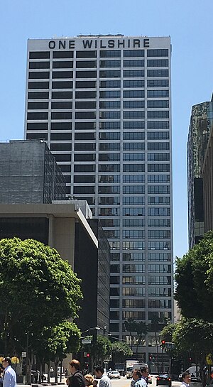
One Wilshire
Office building in Los Angeles, US
Distance: Approx. 37 meters
Latitude and longitude: 34.0479,-118.2556
One Wilshire is an office building located at the junction of Wilshire Boulevard and South Grand Avenue in downtown Los Angeles, California, United States. Located at the easterly end of Wilshire, its address is 624 S. Grand Avenue. Built in 1966, the thirty story high-rise was designed by Skidmore, Owings and Merrill, and for its first decades in existence it was used almost exclusively by law firms.

First Interstate Tower fire
1988 fire in Los Angeles, California
Distance: Approx. 181 meters
Latitude and longitude: 34.04922222,-118.25713889
The First Interstate Tower fire was a high-rise fire that occurred on May 4, 1988, at the First Interstate Tower (now Aon Center) in Los Angeles, California, a 62-story, 860 foot (260 m) skyscraper, then the tallest building in the city. The fire destroyed five floors of the building, injured 40 people, and caused the death of a maintenance worker, when the elevator he was riding opened onto the burning 12th floor.

Brockman Building
United States historic place
Distance: Approx. 111 meters
Latitude and longitude: 34.04696389,-118.25642778
The Brockman Building is a 12-story Beaux-Arts, Classical, and Romanesque Revival style building located on 7th Street in Downtown Los Angeles.

Bank of Italy Building (Los Angeles)
Building in Los Angeles, California, United States
Distance: Approx. 113 meters
Latitude and longitude: 34.04692,-118.25568
The Bank of Italy Building is a historic building in Los Angeles, California, United States, known for many years as Giannini Place. It was converted to a hotel in 2018 and currently operates as Hotel Per La.
Q Sushi
Restaurant in Los Angeles, California, U.S.
Distance: Approx. 82 meters
Latitude and longitude: 34.04716667,-118.25608333
Q Sushi is a sushi restaurant in Los Angeles, California.
Los Angeles Homeless Services Authority
American county agency
Distance: Approx. 174 meters
Latitude and longitude: 34.04921465,-118.25702005
Los Angeles Homeless Services Authority (LAHSA) is the lead agency responsible for coordinating housing and social services for the homeless in Los Angeles County. LAHSA allocates funds and administers contracts with regional agencies that provide emergency, transitional and permanent housing, and other services that assist homeless individuals. In the 2022-2023 fiscal year, LAHSA had an annual budget of US$845,367,023 (equivalent to $880,166,075 in 2023).
Weather in this IP's area
clear sky
23 Celsius
23 Celsius
21 Celsius
26 Celsius
1012 hPa
47 %
1012 hPa
1003 hPa
10000 meters
10.8 m/s
14.92 m/s
270 degree
07:00:51
18:14:55