Country:
 USA
USARegion:
City:
Latitude and Longitude:
Time Zone:
Postal Code:
IP information under different IP Channel
ip-api
Country
Region
City
ASN
Time Zone
ISP
Blacklist
Proxy
Latitude
Longitude
Postal
Route
IPinfo
Country
Region
City
ASN
Time Zone
ISP
Blacklist
Proxy
Latitude
Longitude
Postal
Route
MaxMind
Country
Region
City
ASN
Time Zone
ISP
Blacklist
Proxy
Latitude
Longitude
Postal
Route
Luminati
Country
USRegion
ca
City
ontario
ASN
Time Zone
America/Los_Angeles
ISP
UIA
Latitude
Longitude
Postal
db-ip
Country
Region
City
ASN
Time Zone
ISP
Blacklist
Proxy
Latitude
Longitude
Postal
Route
ipdata
Country
Region
City
ASN
Time Zone
ISP
Blacklist
Proxy
Latitude
Longitude
Postal
Route
Popular places and events near this IP address

Ontario, California
City in California, United States
Distance: Approx. 2641 meters
Latitude and longitude: 34.05277778,-117.62777778
Ontario is a city in southwestern San Bernardino County in the U.S. state of California, 35 miles (56 km) east of downtown Los Angeles and 23 miles (37 km) west of downtown San Bernardino, the county seat. Located in the western part of the Inland Empire metropolitan area, it lies just east of Los Angeles County and is part of the Greater Los Angeles Area. As of the 2020 census, the city had a population of 175,265.

Pomona Valley
Valley in Los Angeles and San Bernardino counties in California
Distance: Approx. 2675 meters
Latitude and longitude: 34.076,-117.657
The Pomona Valley is located in the Greater Los Angeles Area between the San Gabriel Valley and San Bernardino Valley in Southern California. The valley is approximately 30 miles (48 km) east of downtown Los Angeles.
Chaffey Joint Union High School District
School district in California
Distance: Approx. 2279 meters
Latitude and longitude: 34.081118,-117.652081
Chaffey Joint Union High School District is a 9-12 school district located in San Bernardino County, California, United States that serves the communities of Ontario, Montclair, Rancho Cucamonga, and portions of Fontana, Upland, Chino, and Mount Baldy. With more than 25,000 students, it is one of the largest high school districts in the state. The district operates eight comprehensive high schools, one online high school, one continuation high school, one community day school, and one adult education school.
KSPA
South Asian radio station in Ontario, California
Distance: Approx. 2467 meters
Latitude and longitude: 34.09472222,-117.61277778
KSPA (1510 AM "Punjabi Radio USA 1510 AM) is a Punjabi radio station located in Ontario, California. KSPA airs a Punjabi Talk and Punjabi Music. KSPA is one of the South Asian Community in Southern California.

Chaffey High School
Public high school in California, United States
Distance: Approx. 2424 meters
Latitude and longitude: 34.079802,-117.653986
Chaffey High School is a public high school in Ontario, California, United States. It is part of the Chaffey Joint Union High School District and rests on approximately 65 acres (260,000 m2), making it one of the largest high schools by area in California. The school currently serves northern Ontario and southern Rancho Cucamonga.
Valley View High School (Ontario, California)
Public secondary school
Distance: Approx. 1609 meters
Latitude and longitude: 34.085729,-117.614567
Valley View High School is a public secondary school in Ontario, California. It is one of the eleven schools of the Chaffey Joint Union High School District. Valley View is one of two continuation schools in the district and enrolls more than 500 students.

Ontario station (Amtrak)
Rail station in Ontario, California, US
Distance: Approx. 2585 meters
Latitude and longitude: 34.0617,-117.6496
Ontario station is an Amtrak train station in Ontario, California, located on the Union Pacific Railroad Alhambra Subdivision. It is served by the thrice-weekly Sunset Limited/Texas Eagle. The station has a covered, open-air pavilion built by the city in 1991.
University of La Verne College of Law
Law school in California, United States of America
Distance: Approx. 2100 meters
Latitude and longitude: 34.06638889,-117.64722222
The University of La Verne College of Law is the law school of the University of La Verne, a private university in Ontario, California.
American Heritage University of Southern California
For-profit college based in Southern California
Distance: Approx. 1461 meters
Latitude and longitude: 34.070446,-117.613937
American Heritage University of Southern California (AHUSC) is an unaccredited for-profit college based in Southern California. American Heritage University states that it was founded in 2003 and is incorporated in the State of California under the name Heritage University.

Graber Olive House
Distance: Approx. 1817 meters
Latitude and longitude: 34.078373,-117.647573
The Graber Olive House in Ontario, California, is the original site of the longest operating olive packing business in the United States. The family home, in which the product, designated as Graber Olives, was developed, now [when?] is designated as historic, and the original farm is designated as a historic site. The business was founded in 1894, two years after Clifford C. Graber and his brother, Charles, arrived from Clay City, Indiana.
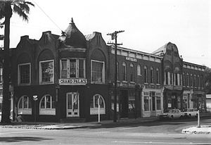
Ontario State Bank Block
United States historic place
Distance: Approx. 2656 meters
Latitude and longitude: 34.06166667,-117.65055556
The Ontario State Bank Block was a historic commercial building located at 300 South Euclid Avenue in Ontario, California. The building, completed in 1887, was composed of three sections, and had a design which incorporated elements of the Eastlake and Queen Anne styles. The design included a corner turret, several gables along the roof line, and a variety of different window styles; it originally had three prominent oriel windows in the gable peaks above the bank's original section, and also had a set in the second section of the block.

Frankish Building
United States historic place
Distance: Approx. 2579 meters
Latitude and longitude: 34.0625,-117.65027778
The Frankish Building is a historic building located at 200 South Euclid Avenue in Ontario, California. Charles Frankish and his son designed and supervised the construction of the building in 1915–16. Frankish was an early investor in Ontario and was responsible for much of the city's planning and promotion, which included constructing a railroad in and planning the layout of the southern half of the city.
Weather in this IP's area
clear sky
17 Celsius
16 Celsius
14 Celsius
20 Celsius
1018 hPa
26 %
1018 hPa
981 hPa
10000 meters
5.81 m/s
11.62 m/s
90 degree
06:59:12
18:11:12