Country:
 USA
USARegion:
City:
Latitude and Longitude:
Time Zone:
Postal Code:
IP information under different IP Channel
ip-api
Country
Region
City
ASN
Time Zone
ISP
Blacklist
Proxy
Latitude
Longitude
Postal
Route
IPinfo
Country
Region
City
ASN
Time Zone
ISP
Blacklist
Proxy
Latitude
Longitude
Postal
Route
MaxMind
Country
Region
City
ASN
Time Zone
ISP
Blacklist
Proxy
Latitude
Longitude
Postal
Route
Luminati
Country
USRegion
ca
City
diamondbar
ASN
Time Zone
America/Los_Angeles
ISP
UIA
Latitude
Longitude
Postal
db-ip
Country
Region
City
ASN
Time Zone
ISP
Blacklist
Proxy
Latitude
Longitude
Postal
Route
ipdata
Country
Region
City
ASN
Time Zone
ISP
Blacklist
Proxy
Latitude
Longitude
Postal
Route
Popular places and events near this IP address
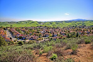
Diamond Bar, California
City in California, United States
Distance: Approx. 1012 meters
Latitude and longitude: 34.00166667,-117.82083333
Diamond Bar is a city in eastern Los Angeles County, California, United States. The 2020 census listed a population of 55,072. It is one of a few cities in California with a majority Asian population (59.24% as of 2020).

Diamond Ranch High School
Public school in Pomona, California, United States
Distance: Approx. 3460 meters
Latitude and longitude: 34.021826,-117.779725
Diamond Ranch High School (or DRHS) is a high school that serves students from Diamond Bar and Phillips Ranch, California, United States, and is operated by the Pomona Unified School District (PUSD) in Pomona, California – part of the Greater Los Angeles MSA. Diamond Ranch's athletic teams compete in the Hacienda League of the CIF Southern Section.
Phillips Ranch, Pomona, California
Neighborhood in Pomona, Los Angeles County, California, United States of America
Distance: Approx. 4099 meters
Latitude and longitude: 34.0361,-117.7842
Phillips Ranch is a master-planned community, first developed by Louis Lesserin 1965. It is located in the southwestern portion of the city limits of Pomona, in Los Angeles County, California. It is located near the Pomona Freeway (SR 60), the Orange Freeway (SR 57), and the Chino Valley Freeway (SR 71).

Diamond Bar High School
Public school in Diamond Bar, California, United States
Distance: Approx. 3736 meters
Latitude and longitude: 33.9825,-117.8392
Diamond Bar High School (DBHS) is a public high school located in Diamond Bar, California, as part of the Walnut Valley Unified School District. Diamond Bar High School's mascot is the Brahma, and the school colors are purple and gold. Diamond Bar High School students participate in programs such as Advanced Placement (AP) and International Baccalaureate (IB).
Walnut High School
Public school in Walnut, California, United States
Distance: Approx. 3704 meters
Latitude and longitude: 34.02193,-117.85033
Walnut High School is a public high school located at Walnut, California, among the San Jose Hills of the San Gabriel Valley in Southern California. Walnut High School is also located within the Walnut Valley Unified School District, which has also been ranked by sources to be one of the top public school districts in all of Southern California. The school is a two-time National Blue Ribbon School (1992–93 and 1997–98), six-time California Distinguished school (1991, 1992, 1994, 1998, 2005 and 2009), and a California Gold Ribbon School (2017).
International Polytechnic High School
Public secondary school
Distance: Approx. 4762 meters
Latitude and longitude: 34.051,-117.8195
International Polytechnic High School, commonly referred to as iPoly, is a public college-preparatory demonstration high school (9-12) found in the California State Polytechnic University, Pomona (Cal Poly Pomona) campus and operated by the Los Angeles County Office of Education (LACOE) in collaboration with the College of Education and Integrative Studies at the university. iPoly's curriculum is fully accredited by the Western Association of Schools and Colleges and is approved by the University of California and California State University. It runs hand-in-hand with the Los Angeles County High School for the Arts (LACHSA), which is also run by LACOE. Since iPoly is not a part of fixed school district, it draws students from all over Los Angeles, San Bernardino, Orange and Riverside counties.
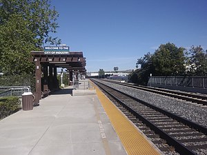
Industry station
Train station in Industry, California, US
Distance: Approx. 2954 meters
Latitude and longitude: 34.0079,-117.8456
Industry station is a Metrolink train station located at 600 South Brea Canyon Road in Industry, California. Metrolink's Riverside Line trains between Los Angeles Union Station and Riverside–Downtown station stop here. It is owned and operated by the City of Industry.
Collins College of Hospitality Management
Distance: Approx. 4591 meters
Latitude and longitude: 34.04972222,-117.81527778
The Collins College of Hospitality Management is a college part of the California State Polytechnic University, Pomona (Cal Poly Pomona). Founded in 1973, it was the first hospitality management studies program in California and its thousand students make it the largest such school in the state. As of 2010, The Collins College of Hospitality Management is ranked third in the nation by restaurant executives.
Rancho Los Nogales
Mexican land grant in southern California
Distance: Approx. 4632 meters
Latitude and longitude: 34.05,-117.81
Rancho Los Nogales was a 1,004-acre (4.06 km2) Mexican land grant in present-day Los Angeles County, California given in 1840 by Governor Juan Alvarado to Jose de la Luz Linares. The name means "Ranch of the Walnut Trees" in Spanish. The triangular-shaped land grant between San Jose Creek and Diamond Bar Creek included parts of present-day Walnut and Diamond Bar.

Hilmer Lodge Stadium
Distance: Approx. 4662 meters
Latitude and longitude: 34.04585,-117.836459
Hilmer Lodge Stadium on the Mt. San Antonio College (Mt. SAC) campus in Walnut, California, is the athletic stadium for the community college.
Cal Poly Pomona College of Letters, Arts, and Social Sciences
Distance: Approx. 4622 meters
Latitude and longitude: 34.050002,-117.815188
The Cal Poly Pomona College of Letters, Arts, and Social Sciences is the humanities, social sciences, and performing arts college at California State Polytechnic University, Pomona (Cal Poly Pomona) located in Pomona, California, United States. The College of Letters, Arts & Social Sciences (C.L.A.S.S.) educates students in eleven disciplines of study: Communication, Economics, English and Modern Languages, Geography and Anthropology, History, Music, Philosophy, Political Science, Psychology and Sociology, Ethnic and Women's Studies, and Theater and New Dance. Academy Award-winning actor, Forest Whitaker, attended Cal Poly Pomona as a Music major.
Lanterman Developmental Center
Hospital in California, United States
Distance: Approx. 4098 meters
Latitude and longitude: 34.04494,-117.8073
Lanterman Developmental Center, opened under the name the Pacific Colony, was a public psychiatric hospital and a facility serving the needs of people with developmental disabilities, and was located in the San Gabriel Valley in what was once Spadra (now part of Pomona), California. In 87 years of operation, the hospital served appropriately 14,000 people. At the time of closure in 2015, the hospital had nine patient buildings, one acute hospital unit, a variety of training and work sites, a vocational training center, and recreation facilities, a research and staff training building, a child day care center for community and staff members' children, a credit union, and the California Conservation Corps.
Weather in this IP's area
clear sky
19 Celsius
18 Celsius
17 Celsius
21 Celsius
1014 hPa
41 %
1014 hPa
985 hPa
10000 meters
0.45 m/s
1.34 m/s
56 degree
06:59:03
18:13:11