66.135.110.36 - IP Lookup: Free IP Address Lookup, Postal Code Lookup, IP Location Lookup, IP ASN, Public IP
Country:
Region:
City:
Location:
Time Zone:
Postal Code:
IP information under different IP Channel
ip-api
Country
Region
City
ASN
Time Zone
ISP
Blacklist
Proxy
Latitude
Longitude
Postal
Route
Luminati
Country
Region
on
City
mississauga
ASN
Time Zone
America/Toronto
ISP
AS-AKN
Latitude
Longitude
Postal
IPinfo
Country
Region
City
ASN
Time Zone
ISP
Blacklist
Proxy
Latitude
Longitude
Postal
Route
IP2Location
66.135.110.36Country
Region
ontario
City
burlington
Time Zone
America/Toronto
ISP
Language
User-Agent
Latitude
Longitude
Postal
db-ip
Country
Region
City
ASN
Time Zone
ISP
Blacklist
Proxy
Latitude
Longitude
Postal
Route
ipdata
Country
Region
City
ASN
Time Zone
ISP
Blacklist
Proxy
Latitude
Longitude
Postal
Route
Popular places and events near this IP address

Burlington, Ontario
City in Halton Region, Ontario, Canada
Distance: Approx. 2143 meters
Latitude and longitude: 43.37,-79.81416667
Burlington is a city and lower-tier municipality in Halton Region at the west end of Lake Ontario in Ontario, Canada. Located approximately halfway between Toronto and Niagara Falls, it is part of the Greater Toronto Area and the Hamilton census metropolitan area.

Burlington (federal electoral district)
Federal electoral district in Ontario, Canada
Distance: Approx. 976 meters
Latitude and longitude: 43.3487,-79.7903
Burlington is a federal electoral district in Halton Region, Ontario, Canada, that has been represented in the House of Commons of Canada since 1979.

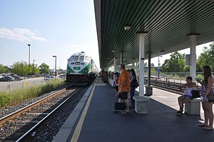
Burlington GO Station
Railway station in Burlington, Ontario, Canada
Distance: Approx. 1602 meters
Latitude and longitude: 43.34083333,-79.80944444
Burlington GO Station is a railway station and bus station in the GO Transit network at 2101 Fairview Street in Burlington, Ontario, Canada, just south of Queen Elizabeth Way between Guelph Line and Brant Street.
Lester B. Pearson High School (Burlington)
Public school in Burlington, Ontario, Canada
Distance: Approx. 2340 meters
Latitude and longitude: 43.37389,-79.80785
Lester B. Pearson High School was a high school located in Burlington, Ontario, Canada, administered by the Halton District School Board. Founded in 1976, the school is named after former Prime Minister Lester B. Pearson. Pearson closed at the end of the 2017–2018 school year, with staff and students moving to M. M. Robinson High School as of September 2018.
Burlington Central High School
Middle school and high school in Burlington, Ontario, Canada
Distance: Approx. 2757 meters
Latitude and longitude: 43.32916667,-79.80583333
Burlington Central High School is a public middle school and high school in Burlington, Ontario, Canada, in the Halton District School Board. Enrolment was 686 students in September 2008. The current school building was constructed in 1922 and has been added to extensively over the years.

M. M. Robinson High School
Public high school in Burlington, Ontario, Canada
Distance: Approx. 2292 meters
Latitude and longitude: 43.3638,-79.8249
M.M. Robinson High School is a high school located in Burlington, Ontario, Canada. It is administered by the Halton District School Board. There are approx.
Assumption Catholic Secondary School
Separate high school in Burlington, Ontario, Canada
Distance: Approx. 1479 meters
Latitude and longitude: 43.3483,-79.78355
Assumption Catholic Secondary School is a Catholic high school in Burlington, Ontario.

Burlington Centre
Shopping mall
Distance: Approx. 808 meters
Latitude and longitude: 43.3475,-79.7949
Burlington Centre (formerly known as Burlington Mall) is a 721,000 square feet (67,000 m2) shopping mall located in Burlington, Ontario, Canada. It is one of the two enclosed malls in Burlington, Ontario, the other being the Mapleview Centre. The stores at Burlington Centre include Hudson's Bay, HomeSense, Old Navy and Winners.

Burlington (provincial electoral district)
Provincial electoral district in Ontario, Canada
Distance: Approx. 976 meters
Latitude and longitude: 43.3487,-79.7903
Burlington is a provincial electoral district in southwestern Ontario, Canada. It elects one member to the Legislative Assembly of Ontario. It was created in 1999 from parts of Burlington South, Halton Centre, and a small part of South Oakville.
Gary Allan High School
Public secondary school in Ontario, Canada
Distance: Approx. 2193 meters
Latitude and longitude: 43.3433,-79.7772
Gary Allan High School (GAHS) is a public secondary school located in Halton Region, Ontario, Canada. GAHS, part of the Halton District School Board. GAHS is oriented towards adult, alternative and Community Education programs.
General Brock High School
Former high school in Burlington, Ontario, Canada
Distance: Approx. 2193 meters
Latitude and longitude: 43.3433,-79.7772
General Brock High School is a former high school in Burlington, Ontario, Canada operated by the Halton District School Board. The school was merged with Lord Elgin High School to form Robert Bateman High School in 2004. The site of the high school was then used for Gary Allan High School, an adult and continuing education school.
Nelson Stadium
Distance: Approx. 2763 meters
Latitude and longitude: 43.359674,-79.767201
Nelson Stadium is a multi-purpose outdoor sports facility in Burlington, Ontario. The stadium is owned by the Halton District School Board and is operated by Nelson High School. It is located on New Street, Burlington's south-east district.
Weather in this IP's area
broken clouds
9 Celsius
8 Celsius
8 Celsius
10 Celsius
1018 hPa
86 %
1018 hPa
999 hPa
10000 meters
2.06 m/s
260 degree
63 %
