66.135.110.19 - IP Lookup: Free IP Address Lookup, Postal Code Lookup, IP Location Lookup, IP ASN, Public IP
Country:
Region:
City:
Location:
Time Zone:
Postal Code:
ISP:
ASN:
language:
User-Agent:
Proxy IP:
Blacklist:
IP information under different IP Channel
ip-api
Country
Region
City
ASN
Time Zone
ISP
Blacklist
Proxy
Latitude
Longitude
Postal
Route
db-ip
Country
Region
City
ASN
Time Zone
ISP
Blacklist
Proxy
Latitude
Longitude
Postal
Route
IPinfo
Country
Region
City
ASN
Time Zone
ISP
Blacklist
Proxy
Latitude
Longitude
Postal
Route
IP2Location
66.135.110.19Country
Region
ontario
City
guelph
Time Zone
America/Toronto
ISP
Language
User-Agent
Latitude
Longitude
Postal
ipdata
Country
Region
City
ASN
Time Zone
ISP
Blacklist
Proxy
Latitude
Longitude
Postal
Route
Popular places and events near this IP address

Guelph
City in Ontario, Canada
Distance: Approx. 2337 meters
Latitude and longitude: 43.53583333,-80.22888889
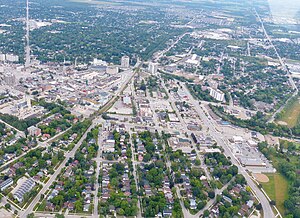
Guelph ( GWELF; 2021 Canadian Census population 143,740) is a city in Southwestern Ontario, Canada. Known as The Royal City, it is roughly 22 km (14 mi) east of Kitchener and 70 km (43 mi) west of Downtown Toronto, at the intersection of Highway 6, Highway 7 and Wellington County Road 124. It is the seat of Wellington County, but is politically independent of it.

Ontario Veterinary College
Distance: Approx. 1748 meters
Latitude and longitude: 43.53115,-80.23233
The Ontario Veterinary College (OVC) is the oldest veterinary school in Canada. It is located on the campus of the University of Guelph in Guelph, Ontario. The OVC is one of five veterinary schools that offer the Doctor of Veterinary Medicine, DVM program in Canada.

Ontario Universities' Application Centre
Canadian higher education applications organization
Distance: Approx. 1023 meters
Latitude and longitude: 43.521,-80.2296
The Ontario Universities' Application Centre (OUAC) (French: Centre de demande d’admission aux universités de l’Ontario) is a non-profit organization based in Guelph that processes online applications for admission to universities in Ontario, Canada. It was founded in 1971 by the Council of Ontario Universities and the Ontario Universities' Council on Admissions, to reduce the duplication and costs involved in processing applications.

College Heights Secondary School (Guelph)
School in Guelph, Ontario, Canada
Distance: Approx. 1034 meters
Latitude and longitude: 43.5225,-80.2508
College Heights Secondary School is a public high school located in Guelph, Ontario, Canada. It is part of the Upper Grand District School Board.

University of Guelph
Public university in Guelph, Ontario, Canada
Distance: Approx. 2314 meters
Latitude and longitude: 43.53333333,-80.22361111
The University of Guelph (abbreviated U of G) is a comprehensive public research university in Guelph, Ontario, Canada. It was established in 1964 after the amalgamation of Ontario Agricultural College (1874), the MacDonald Institute (1903), and the Ontario Veterinary College (1922), and has since grown to an institution of almost 30,000 students (including those at the Humber campus, Ridgetown campus, off-campus degree enrolments, diploma enrolments and part-time students) and employs 830 full-time faculty (academic staff) as of fall 2019. It offers 94 undergraduate degrees, 48 graduate programs, and 6 associate degrees in many different disciplines.

McCrae House
House in Guelph, Ontario, Canada
Distance: Approx. 2178 meters
Latitude and longitude: 43.53602778,-80.24502778
McCrae House, located in Guelph, Ontario, is the birthplace of John McCrae (b. 1872 – d. 1918), doctor, soldier and author of the famous First World War poem "In Flanders Fields".

Stone Road Mall
Shopping mall in Guelph, Ontario
Distance: Approx. 342 meters
Latitude and longitude: 43.519,-80.238
Stone Road Mall is a shopping mall in Guelph, Ontario, Canada, situated at Stone Road West and Edinburgh Road. It is the largest shopping mall in Guelph, with approximately 520,000 square feet (50,000 m2) of gross leasable area and 130 stores. It is operated by Primaris Management Inc., and its anchors are Marshalls, Sport Chek, and Chapters-Indigo following the closure of the third anchor tenant, Sears.
Johnston Hall (University of Guelph)
Distance: Approx. 2077 meters
Latitude and longitude: 43.53308,-80.22848
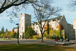
Johnston Hall at the University of Guelph was named after William Johnston (1848–1885) who was the founder and first principal of the Ontario Agricultural College from 1874 to 1879. Johnston Hall was built in 1931 as a student residence and home of administrative offices. Johnston Hall is the second building that opened in 1932 as the first building, the Italianate-style Moreton Lodge, was demolished in 1928 - this is represented by the portico which resides on Johnston Green.
Gordon S. Lang School of Business and Economics
Business school in Guelph, Ontario, Canada
Distance: Approx. 2058 meters
Latitude and longitude: 43.5322,-80.2269
The Gordon S. Lang School of Business and Economics (formerly the College of Business and Economics) is the business school of the University of Guelph, in Guelph, Ontario. After receiving a $21-million donation from Stu and Kim Lang, the College was renamed to the Gordon S. Lang School of Business and Economics on April 3, 2019, honouring Stu's late father. Overseeing the transformation of the business school, was dean Dr.

Art Gallery of Guelph
Public gallery in Ontario, Canada
Distance: Approx. 1923 meters
Latitude and longitude: 43.533,-80.2329
The Art Gallery of Guelph (AGG), formerly the Macdonald Stewart Art Centre, is a public gallery and adjoining Sculpture garden in Guelph, Ontario. Its collection consists of over 9,000 works. The AGG is a nonprofit organization which focuses on research, publishing, educational programs, and touring exhibitions.

Alumni Stadium (Guelph)
Stadium in Guelph, Ontario
Distance: Approx. 2343 meters
Latitude and longitude: 43.5351,-80.2267
Alumni Stadium is a multi-purpose stadium at the University of Guelph in Guelph, Ontario, Canada. It is home to the Guelph Gryphons varsity football team. It was built in 1970, and has a fixed seating capacity of approximately 8,500, including fixed seating and the grass hill on the east side of the stadium.
RCAF Station Guelph
Military unit
Distance: Approx. 1994 meters
Latitude and longitude: 43.5325,-80.22916667
RCAF Station Guelph was a Second World War British Commonwealth Air Training Plan (BCATP) station located in Guelph, Ontario on the campus of the Ontario Agricultural College (OAC), the Ontario Veterinary College (OVC), and the Macdonald Institute. The station is usually known as No. 4 Wireless School and was home to several schools as well as test facilities for air force kitchens.
Weather in this IP's area
clear sky
-11 Celsius
-17 Celsius
-12 Celsius
-10 Celsius
1023 hPa
85 %
1023 hPa
979 hPa
10000 meters
5.14 m/s
280 degree

