66.135.109.95 - IP Lookup: Free IP Address Lookup, Postal Code Lookup, IP Location Lookup, IP ASN, Public IP
Country:
Region:
City:
Location:
Time Zone:
Postal Code:
ISP:
ASN:
language:
User-Agent:
Proxy IP:
Blacklist:
IP information under different IP Channel
ip-api
Country
Region
City
ASN
Time Zone
ISP
Blacklist
Proxy
Latitude
Longitude
Postal
Route
db-ip
Country
Region
City
ASN
Time Zone
ISP
Blacklist
Proxy
Latitude
Longitude
Postal
Route
IPinfo
Country
Region
City
ASN
Time Zone
ISP
Blacklist
Proxy
Latitude
Longitude
Postal
Route
IP2Location
66.135.109.95Country
Region
ontario
City
oshawa
Time Zone
America/Toronto
ISP
Language
User-Agent
Latitude
Longitude
Postal
ipdata
Country
Region
City
ASN
Time Zone
ISP
Blacklist
Proxy
Latitude
Longitude
Postal
Route
Popular places and events near this IP address
Oshawa
City in Ontario, Canada
Distance: Approx. 2805 meters
Latitude and longitude: 43.90055556,-78.85722222
Oshawa is a city in Ontario, Canada, on the Lake Ontario shoreline. It lies in Southern Ontario, approximately 60 km (37 mi) east of Downtown Toronto. It is commonly viewed as the eastern anchor of the Greater Toronto Area and of the Golden Horseshoe.

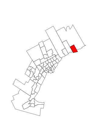
Oshawa (federal electoral district)
Federal electoral district in Ontario, Canada
Distance: Approx. 2052 meters
Latitude and longitude: 43.9009,-78.8454
Oshawa (formerly known as Oshawa—Whitby) is a federal electoral district in Ontario, Canada, that is represented in the House of Commons of Canada. It currently consists of the City of Oshawa south of Taunton Road. Historically, the riding was dominated by a working-class electorate.
Dr. F. J. Donevan Collegiate Institute
Public school in Oshawa, Ontario, Canada
Distance: Approx. 1087 meters
Latitude and longitude: 43.89742,-78.8318
Dr F J Donevan Collegiate Institute was located in Oshawa, Ontario, within the Durham District School Board. The school had students in grades 9–12 and offered a wide range of academic and extracurricular activities.
Eastdale Collegiate and Vocational Institute
High school in Oshawa, Ontario, Canada
Distance: Approx. 2712 meters
Latitude and longitude: 43.9118,-78.836
Eastdale Collegiate and Vocational Institute is located in Oshawa, Ontario within the Durham District School Board. The school has students in grades 9-12 and offers a wide range of academic and extracurricular activities. Eastdale offers courses in construction, communications, and manufacturing technology, as well as technical design.

General Motors Canada
Canada's division of General Motors
Distance: Approx. 2255 meters
Latitude and longitude: 43.87611,-78.804253
General Motors of Canada Company (French: La Compagnie General Motors du Canada), commonly known as GM Canada, is the Canadian subsidiary of US-based company General Motors. It is headquartered in Oshawa, Ontario, Canada. In the aftermath of the 2008 financial crisis, GM Canada received a combined loan commitment of CA$3 billion of financial assistance from the federal and provincial governments amid declining sales.

Tribute Communities Centre
Multi-purpose arena located in Oshawa
Distance: Approx. 2833 meters
Latitude and longitude: 43.89722222,-78.85972222
The Tribute Communities Centre, formerly known as the General Motors Centre or GM Centre, GMC for short, is a multi-purpose arena located in downtown Oshawa, Ontario, Canada, which opened in November 2006. The arena was constructed to replace the Oshawa Civic Auditorium. The main tenant is the Oshawa Generals of the Ontario Hockey League, and formerly the Durham TurfDogs of the Canadian Lacrosse League.
Kingsway College
Private boarding high school in Oshawa, Ontario, Canada
Distance: Approx. 2441 meters
Latitude and longitude: 43.9099092,-78.8206958
Kingsway College is a Seventh-day Adventist high school in Oshawa, Ontario, Canada. It is a former degree-granting post-secondary institution, having offered post-secondary education from 1916 to 1975.

Oshawa (provincial electoral district)
Provincial electoral district in Ontario, Canada
Distance: Approx. 2052 meters
Latitude and longitude: 43.9009,-78.8454
Oshawa is a provincial electoral district in Ontario, Canada, that has been represented in the Legislative Assembly of Ontario since 1955.
Oshawa Museum
Historical museum in Ontario, Canada
Distance: Approx. 2727 meters
Latitude and longitude: 43.8639,-78.8269
The Oshawa Museum is a historical museum founded by the Oshawa Historical Society, located in Oshawa, Ontario, Canada. It has a dual role as a museum; exhibits for the general public, and archival storage of the city's historical documents. Every building in the museum is designated under the Ontario Heritage Act The museum preserves and celebrates the history of Oshawa, and the surrounding area from the 15th century to the present day.
Ritson Road GO Station
Railway station in Oshawa, Ontario, Canada
Distance: Approx. 2167 meters
Latitude and longitude: 43.88833333,-78.85361111
Ritson Road GO Station is a planned GO Transit train station to be built by Metrolinx in Oshawa, Ontario, Canada as part of the approved expansion of train service on the Lakeshore East line to Bowmanville. It will be built on the south side of an existing freight rail line owned by Canadian Pacific Railway, on a section of land formerly occupied by Ontario Malleable Iron Company until 1977 and later by Knob Hill Farms (1980 to 2000) at 500 Howard Street in downtown Oshawa. In 2011, Metrolinx planned to abandon service at its existing Oshawa GO Station once the expansion was completed; thus, at that time, the Ritson Road location would have become the new Oshawa GO Station.
Oshawa Creek
Distance: Approx. 2270 meters
Latitude and longitude: 43.8681,-78.8293
Oshawa Creek is a watercourse that flows 50 kilometres (31 mi) from its headwaters in the Oak Ridges Moraine to its mouth on Lake Ontario, at Oshawa, Ontario. It drains a watershed of 120 square kilometres (46 sq mi). In its lowest reaches, in Oshawa, two tributaries, Goodman's Creek and Montgomery Creek, join the watercourse.
Farewell Creek
Distance: Approx. 2363 meters
Latitude and longitude: 43.8695,-78.8132
Farewell Creek is a watercourse in Durham County, that empties into Lake Ontario, at Oshawa, Ontario. It drains a watershed of 10,726 hectares (41.41 sq mi). To the west and east it borders Oshawa Creek, and Bowmanville Creek, which have their headwaters in the Oak Ridges Moraine.
Weather in this IP's area
overcast clouds
-6 Celsius
-11 Celsius
-7 Celsius
-5 Celsius
1005 hPa
62 %
1005 hPa
985 hPa
10000 meters
3.6 m/s
220 degree
100 %
