66.135.109.210 - IP Lookup: Free IP Address Lookup, Postal Code Lookup, IP Location Lookup, IP ASN, Public IP
Country:
Region:
City:
Location:
Time Zone:
Postal Code:
ISP:
ASN:
language:
User-Agent:
Proxy IP:
Blacklist:
IP information under different IP Channel
ip-api
Country
Region
City
ASN
Time Zone
ISP
Blacklist
Proxy
Latitude
Longitude
Postal
Route
db-ip
Country
Region
City
ASN
Time Zone
ISP
Blacklist
Proxy
Latitude
Longitude
Postal
Route
IPinfo
Country
Region
City
ASN
Time Zone
ISP
Blacklist
Proxy
Latitude
Longitude
Postal
Route
IP2Location
66.135.109.210Country
Region
ontario
City
london
Time Zone
America/Toronto
ISP
Language
User-Agent
Latitude
Longitude
Postal
ipdata
Country
Region
City
ASN
Time Zone
ISP
Blacklist
Proxy
Latitude
Longitude
Postal
Route
Popular places and events near this IP address

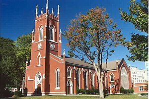
St. Paul's Cathedral (London, Ontario)
Church in London, Ontario
Distance: Approx. 579 meters
Latitude and longitude: 42.9858,-81.2496
St. Paul's Cathedral in London, Ontario, Canada, is the seat of the Diocese of Huron of the Anglican Church of Canada. It was designed in the Gothic revival style by William Thomas and built between 1844 and 1846, replacing the previous church, which was built in 1834 and burned down in 1844.
Canadian Medical Hall of Fame
Canadian charitable organization
Distance: Approx. 254 meters
Latitude and longitude: 42.98513,-81.24555
The Canadian Medical Hall of Fame is a Canadian charitable organization, founded in 1994, that honours Canadians who have contributed to the understanding of disease and improving the health of people. It has an exhibit hall in London, Ontario, an annual induction ceremony, career exploration programs for youth and a virtual hall of fame.
CHRW-FM
Radio station at the University of Western Ontario in Canada
Distance: Approx. 342 meters
Latitude and longitude: 42.9856,-81.2467
CHRW-FM (branded as Radio Western) is a Canadian radio station, broadcasting at 94.9 FM in London, Ontario. It is licensed as a community-based campus radio station by the Canadian Radio-television and Telecommunications Commission. The station broadcasts from Room 250 of the University Community Centre at the University of Western Ontario.

London station (Ontario)
Intercity train station in London, Ontario
Distance: Approx. 520 meters
Latitude and longitude: 42.9819,-81.2464
London station (French: Gare de London, IATA: XDQ) in London, Ontario, Canada is a major interchange for Via Rail trains running from Toronto west to Sarnia and Windsor. The station is a large, modern, wheelchair accessible building on the south end of the city centre, and connects to local public transit bus services.
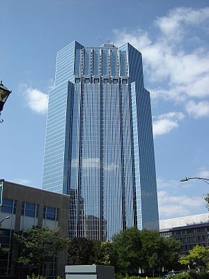
One London Place
High-rise office building in London, Ontario
Distance: Approx. 333 meters
Latitude and longitude: 42.98573,-81.24659
One London Place is a high-rise office building in London, Ontario, Canada. Construction of the tower was completed in 1992 Besides office space, One London Place has a restaurant, fitness centre, newsstand, Pristine Auto Detailing car wash, and 382-space underground parking lot.

Catholic Central High School (London, Ontario)
Catholic high school in London, Ontario, Canada
Distance: Approx. 398 meters
Latitude and longitude: 42.9883,-81.2393
Catholic Central High School (CCH) in London, was Ontario's first Jr. Catholic High School, opened with grades 7 to 13 in September 1950. The new building was a Junior High School with grades 7 to 10.

London Public Library
Library system in London, Ontario, Canada
Distance: Approx. 219 meters
Latitude and longitude: 42.98661111,-81.24480556
The London Public Library (LPL) is the public library system of London, Ontario, Canada. All 16 locations city-wide offer services and programs for adults, teens and children residing in London and the surrounding counties of Oxford, Middlesex, and Elgin. The branches includes art exhibits, author readings, a summer reading program, and health-oriented activities.

Home County Music & Art Festival
Folk music and crafts festival in London, Ontario
Distance: Approx. 586 meters
Latitude and longitude: 42.989,-81.248
The Home County Music & Art Festival (formerly Home County Folk Festival) is a festival held the third weekend of July in London, Ontario. The founders chose the name "H.O.M.E County" because it was an acronym of the nearby counties of Huron, Oxford, Middlesex, and Elgin. The festival is an admission by donation and is held in Victoria Park, London, Ontario.

CHJX-FM
Radio station in Ontario, Canada
Distance: Approx. 333 meters
Latitude and longitude: 42.98573,-81.24659
CHJX-FM is a Canadian radio station, broadcasting 24 hours a day on 99.9 FM in London, Ontario. The station airs a Contemporary Christian music format branded as Faith 99.9 (ninety-nine nine). CHJX-FM broadcasts several evangelistic teaching programs, Christian music in the morning and mid-day, with Christian contemporary music during the evening and overnight.
City Centre Towers
London City Centre is a twin office tower complex in London, Ontario
Distance: Approx. 333 meters
Latitude and longitude: 42.98573,-81.24659
City Centre or London City Centre is a twin office tower complex in London, Ontario, Canada at 275 Dundas Street. Construction on the towers was finished in 1974. The South tower is 96 m tall, and is the second tallest building in the city and one of the tallest office buildings in Ontario outside Toronto.

London Fire Department
Emergency services department
Distance: Approx. 532 meters
Latitude and longitude: 42.98245381,-81.23758536
The London Fire Department (LFD) provides fire prevention, life preservation, and technical rescue services to the city of London, Ontario, Canada.
Fluidesign
Manufacturer of racing rowing shells
Distance: Approx. 160 meters
Latitude and longitude: 42.98695,-81.243177
Fluidesign is a rowing racing shell manufacturer headquartered in London, Ontario.
Weather in this IP's area
overcast clouds
-6 Celsius
-13 Celsius
-7 Celsius
-5 Celsius
1025 hPa
75 %
1025 hPa
991 hPa
10000 meters
6.17 m/s
240 degree
100 %

