Country:
Region:
City:
Latitude and Longitude:
Time Zone:
Postal Code:
IP information under different IP Channel
ip-api
Country
Region
City
ASN
Time Zone
ISP
Blacklist
Proxy
Latitude
Longitude
Postal
Route
Luminati
Country
ASN
Time Zone
America/Chicago
ISP
CORESITE
Latitude
Longitude
Postal
IPinfo
Country
Region
City
ASN
Time Zone
ISP
Blacklist
Proxy
Latitude
Longitude
Postal
Route
db-ip
Country
Region
City
ASN
Time Zone
ISP
Blacklist
Proxy
Latitude
Longitude
Postal
Route
ipdata
Country
Region
City
ASN
Time Zone
ISP
Blacklist
Proxy
Latitude
Longitude
Postal
Route
Popular places and events near this IP address

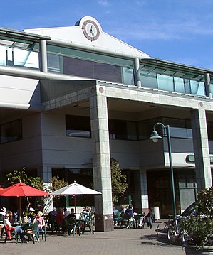
Menlo Park, California
City in California, United States
Distance: Approx. 120 meters
Latitude and longitude: 37.45277778,-122.18333333
Menlo Park ( MEN-loh) is a city at the eastern edge of San Mateo County in the San Francisco Bay Area of California, United States. It is bordered by San Francisco Bay on the north and east; East Palo Alto, Palo Alto, and Stanford to the south; and Atherton, North Fair Oaks, and Redwood City to the west. It had 33,780 residents at the 2020 United States census.

SRI International
American scientific research institute (founded 1946)
Distance: Approx. 715 meters
Latitude and longitude: 37.4566,-122.1753
SRI International (SRI) is a nonprofit scientific research institute and organization headquartered in Menlo Park, California, United States. It was established in 1946 by trustees of Stanford University to serve as a center of innovation to support economic development in the region. The organization was founded as the Stanford Research Institute.

Menlo College
Private business college in Atherton, California, US
Distance: Approx. 997 meters
Latitude and longitude: 37.455,-122.193
Menlo College is a private college specializing in business and located in Atherton, California, United States.

Kepler's Books
Distance: Approx. 56 meters
Latitude and longitude: 37.4535,-122.182
Kepler's Books and Magazines is an independent bookstore in Menlo Park, California. It was founded on May 14, 1955 by Roy Kepler, a peace activist who had endured multiple internments as a conscientious objector during World War II. Kepler previously had worked as a staff member of radio station KPFA, listener-supported and based in Berkeley.

Menlo School
Independent school in Atherton, California, United States
Distance: Approx. 858 meters
Latitude and longitude: 37.4533,-122.1917
Menlo School, commonly referred to as just Menlo, is a private college preparatory school in Atherton, California, United States. The school comprises a middle school, grades 6–8, with approximately 230 students and a high school, grades 9–12, with about 600 students. The middle and high school share a campus and have some overlapping administration, such as the Head of School.
Mental Research Institute
Systemic and family therapy organization in Palo Alto, California, US
Distance: Approx. 253 meters
Latitude and longitude: 37.45331,-122.18484
The Palo Alto Mental Research Institute (MRI) is one of the founding institutions of brief and family therapy. Founded by Don D. Jackson and colleagues in 1958, MRI has been one of the leading sources of ideas in the area of interactional/systemic studies, psychotherapy, and family therapy.

Menlo Park station
Train station in Menlo Park, California, U.S.
Distance: Approx. 185 meters
Latitude and longitude: 37.454607,-122.182526
Menlo Park station is a Caltrain station located in Menlo Park, California. The station was originally built in 1867 by the San Francisco and San Jose Railroad and acquired by the Southern Pacific Railroad. During the 1890s, Southern Pacific added Victorian ornamentation to the depot to make it appear more attractive to students and visitors to Stanford University.
Menlo Church
Church in California , United States
Distance: Approx. 651 meters
Latitude and longitude: 37.4493,-122.1877
Menlo Church, previously Menlo Park Presbyterian Church, is a Presbyterian church congregation located in the San Francisco Bay Area with campuses in Menlo Park, Mountain View, San Mateo, and Saratoga, California.

California Volcano Observatory
Research center in California, United States
Distance: Approx. 1011 meters
Latitude and longitude: 37.45638889,-122.17138889
The California Volcano Observatory (CalVO) is the volcano observatory that monitors the volcanic and geologic activity of California and Nevada. It is a part of the Volcano Hazards Program of the United States Geological Survey, a scientific agency of the United States government. Originally, the volcano observatory was known as the Long Valley Observatory which monitored volcanic activity east of the Sierra Nevada in Mono County, California which included Long Valley Caldera, Mammoth Mountain, and the Mono–Inyo Craters.
Camp Fremont
US military base in Palo Alto, California (1917–1919)
Distance: Approx. 603 meters
Latitude and longitude: 37.4488275,-122.1863539
Camp Fremont was a World War I-era military base located near Palo Alto, California. Construction started in July 1917 and the post closed in September, 1919. The post was named for John C. Frémont, a US Army officer and government official who was prominent in California during the 1850s.

Church of the Nativity (Menlo Park, California)
Historic church in California, United States
Distance: Approx. 884 meters
Latitude and longitude: 37.4607717,-122.1799648
Church of the Nativity is a historic Roman Catholic church on the National Register of Historic Places in Menlo Park, California. It was built in 1887 and added to the National Register in 1980.
Capidro Folk Art
Historical site in Menlo Park, California, US
Distance: Approx. 1111 meters
Latitude and longitude: 37.443254,-122.179274
Capidro is a historical site in Menlo Park, California, in San Mateo County. Capidro site is a California Historical Landmark No. 939.8.
Weather in this IP's area
clear sky
15 Celsius
14 Celsius
13 Celsius
17 Celsius
1017 hPa
36 %
1017 hPa
1015 hPa
10000 meters
4.12 m/s
290 degree
06:50:06
16:57:26