66.117.65.204 - IP Lookup: Free IP Address Lookup, Postal Code Lookup, IP Location Lookup, IP ASN, Public IP
Country:
 USA
USARegion:
City:
Location:
Time Zone:
Postal Code:
ISP:
ASN:
language:
User-Agent:
Proxy IP:
Blacklist:
IP information under different IP Channel
ip-api
Country
Region
City
ASN
Time Zone
ISP
Blacklist
Proxy
Latitude
Longitude
Postal
Route
db-ip
Country
Region
City
ASN
Time Zone
ISP
Blacklist
Proxy
Latitude
Longitude
Postal
Route
IPinfo
Country
Region
City
ASN
Time Zone
ISP
Blacklist
Proxy
Latitude
Longitude
Postal
Route
IP2Location
66.117.65.204Country
usRegion
washington
City
liberty lake
Time Zone
America/Los_Angeles
ISP
Language
User-Agent
Latitude
Longitude
Postal
ipdata
Country
Region
City
ASN
Time Zone
ISP
Blacklist
Proxy
Latitude
Longitude
Postal
Route
Popular places and events near this IP address

Stateline, Idaho
City in Idaho, United States
Distance: Approx. 6692 meters
Latitude and longitude: 47.70527778,-117.03694444
Stateline, officially the City of State Line, and historically known as State Line Village, is a city in Kootenai County, Idaho, United States, and is both the easternmost suburb of Spokane, Washington and the westernmost suburb of Coeur d'Alene, Idaho. The population was 39 at the 2020 census. The city is known for the adult services it provides which attract business from nearby Spokane and Coeur d'Alene.

Greenacres, Washington
Locale in Washington, United States
Distance: Approx. 5682 meters
Latitude and longitude: 47.66333333,-117.15666667
Greenacres is a locale and former census-designated place (CDP) in Spokane County, Washington, United States. The locale is almost entirely split between the city of Spokane Valley and unincorporated Spokane County, with a small portion being located within the city of Liberty Lake. Greenacres retains its own post office.

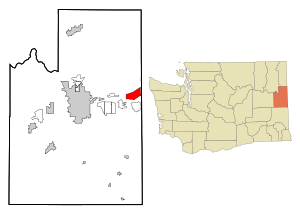
Liberty Lake, Washington
City in Washington, United States
Distance: Approx. 3274 meters
Latitude and longitude: 47.66833333,-117.12
Liberty Lake is a city in Spokane County, Washington, United States, located adjacent to the eponymous lake. Located just over a mile (about 2 km) west of the Washington–Idaho border, Liberty Lake is both a suburb of Spokane, Washington and a bedroom community to Coeur d'Alene, Idaho. The population was 12,003 at the 2020 census.
Otis Orchards-East Farms, Washington
CDP in Washington, United States
Distance: Approx. 5409 meters
Latitude and longitude: 47.69916667,-117.10694444
Otis Orchards-East Farms is a census-designated place (CDP) in Spokane County, Washington, United States, near the county's border with Idaho. The population was 6,299 at the 2020 census. The CDP includes the unincorporated communities of Otis Orchards and East Farms.

Central Valley School District (Washington)
School district in Spokane Valley, Washington, U.S.
Distance: Approx. 2768 meters
Latitude and longitude: 47.67777778,-117.09027778
Central Valley School District No. 356 is a K–12 public school district located in Spokane Valley and Liberty Lake, Washington. Over 14,100 students attend one of the twenty-one schools within the district.

Cable Creek
Stream in the state of Idaho
Distance: Approx. 4312 meters
Latitude and longitude: 47.69055556,-117.06555556
Cable Creek is a stream of approximately 9 miles (14 km) which rises in the U.S. state of Idaho and has its mouth across the state line in Washington. A tributary of the Spokane River that flows from the forested slopes of Mica Peak into the suburban Spokane Valley just east of the city of Liberty Lake.
Saltese Uplands Conservation Area
Distance: Approx. 3017 meters
Latitude and longitude: 47.641,-117.118
The Saltese Uplands Conservation Area is a 522 acre conservation area in Spokane County in the U.S. state of Washington. The conservation area covers the Saltese Uplands, which are situated on the western slope of the Holiday Hills, immediately to the east of the adjacent Saltese Flats. The area is open to the public and contains 7 miles (11 km) of trails.

Saltese Flats
Distance: Approx. 4439 meters
Latitude and longitude: 47.629,-117.129
The Saltese Flats is a flat located in Spokane County, just outside Greenacres Washington, United States. The flats are occupied by the residual wetlands of the now-drained Saltese Lake. The term Saltese Flats is generally used to refer to both the flat and the occupying wetlands.
Holiday Hills (Washington)
Loam hills in Spokane County, Washington
Distance: Approx. 2888 meters
Latitude and longitude: 47.65018,-117.1205
The Holiday Hills are a series of mostly treeless, loam hills in Spokane County, Washington, in the foothills of the Selkirk Range. The portion of the hills immediately to the east of the adjacent Saltese Flats are known as the Saltese Uplands.
Spokane Bridge, Washington
Unincorporated Community in Washington, United States
Distance: Approx. 5245 meters
Latitude and longitude: 47.6943445,-117.0474218
Spokane Bridge is an unincorporated community and former census-designated place in Spokane County, in the U.S. state of Washington. The community is located on the banks of the Spokane River at the Washington–Idaho border, just south of Interstate 90. The city of Stateline, Idaho is located across the river to the northeast.
Liberty Lake (Washington)
Lake in Washington state,US
Distance: Approx. 982 meters
Latitude and longitude: 47.6451538,-117.0780555
Liberty Lake is a lake located in Spokane County, Washington, in the United States. The lake is approximately 800 feet (240 m) south of the eponymous city, and is a popular fishing spot. The lake forms part of the Spokane Valley–Rathdrum Prairie Aquifer.

Ridgeline High School (Washington)
Public high school in Liberty Lake, Washington, United States
Distance: Approx. 4284 meters
Latitude and longitude: 47.66291597,-117.13769281
Ridgeline High School (RHS), often referred to as simply Ridgeline, is a comprehensive public high school for grades nine through twelve in Liberty Lake, Washington, United States. It is part of the Central Valley School District in Spokane County, and is one of three such high schools in the district along with Central Valley High School and University High School.
Weather in this IP's area
mist
-19 Celsius
-25 Celsius
-20 Celsius
-17 Celsius
1031 hPa
82 %
1031 hPa
932 hPa
3219 meters
2.57 m/s
100 %