66.114.152.220 - IP Lookup: Free IP Address Lookup, Postal Code Lookup, IP Location Lookup, IP ASN, Public IP
Country:
 USA
USARegion:
City:
Location:
Time Zone:
Postal Code:
ISP:
ASN:
language:
User-Agent:
Proxy IP:
Blacklist:
IP information under different IP Channel
ip-api
Country
Region
City
ASN
Time Zone
ISP
Blacklist
Proxy
Latitude
Longitude
Postal
Route
db-ip
Country
Region
City
ASN
Time Zone
ISP
Blacklist
Proxy
Latitude
Longitude
Postal
Route
IPinfo
Country
Region
City
ASN
Time Zone
ISP
Blacklist
Proxy
Latitude
Longitude
Postal
Route
IP2Location
66.114.152.220Country
usRegion
california
City
fullerton
Time Zone
America/Los_Angeles
ISP
Language
User-Agent
Latitude
Longitude
Postal
ipdata
Country
Region
City
ASN
Time Zone
ISP
Blacklist
Proxy
Latitude
Longitude
Postal
Route
Popular places and events near this IP address

Fox Theatre (Fullerton, California)
Distance: Approx. 993 meters
Latitude and longitude: 33.87444444,-117.92388889
Fox Theatre is a historic movie theater located on Harbor Boulevard in Fullerton, California. Built in 1925 as part of the chain of Fox Theatres, the theater was closed and abandoned in 1987. The Fullerton Historic Theatre Foundation is currently in the process of fundraising and restoring the theater.

Fullerton Transportation Center
Transit center in Fullerton, California, U.S.
Distance: Approx. 572 meters
Latitude and longitude: 33.868612,-117.9223
The Fullerton Transportation Center is a transit center located in Fullerton, California, United States. It is served by Amtrak's Pacific Surfliner and Southwest Chief trains, as well as Metrolink's 91/Perris Valley Line and Orange County Line trains. It is also a major bus depot for the OC Bus system, and is one of the major transportation hubs of Orange County.

Fullerton Public Library
Public library system in California, USA
Distance: Approx. 583 meters
Latitude and longitude: 33.87072617,-117.93064579
The Fullerton Public Library (FPL), is a public library system that serves the City of Fullerton, California and its surrounding communities. The Library holds more than 200,000 volumes and serves a population of ca. 142,000.

Fullerton Police Department
Police department in Fullerton, California
Distance: Approx. 509 meters
Latitude and longitude: 33.87065416,-117.92817364
The Fullerton Police Department of Fullerton, California, was established in 1904 when the city was incorporated. The Fullerton Police Department currently employs 153 sworn officers and 78 civilian employees. It has a budget of about $54.7 million.

Elephant Packing House
United States historic place
Distance: Approx. 252 meters
Latitude and longitude: 33.8675,-117.92555556
The Elephant Packing House was built in 1924, in Fullerton, Orange County, Southern California. Valencia oranges were packed here, from the abundant orchards that then dominated the county. William Wolfskill had developed and extensively planted the Valencia orange here in the 19th century.

Spring Field Banquet Center
United States historic place
Distance: Approx. 974 meters
Latitude and longitude: 33.87416667,-117.92361111
The Spring Field Banquet Center in Fullerton, California is a historic building built in Mission/Spanish Revival style. It was listed in the National Register of Historic Places in 1995. Originally constructed in 1920 as a Masonic meeting hall, the Freemasons sold the building in 1993, due to declining membership and funds.

Fullerton Odd Fellows Temple
United States historic place
Distance: Approx. 599 meters
Latitude and longitude: 33.87027778,-117.92361111
The Fullerton Odd Fellows Temple, also known as IOOF Building or Independent Order of Odd Fellows Lodge No.103 or Williams Building, is located in Fullerton, Orange County, California. It was designed by Oliver S. Compton-Hall and built during 1927-28 for the Independent Order of Odd Fellows Lodge Number 103, which existed from 1901 to 1981. It is located in the historic downtown area of Fullerton, facing the Santa Fe Railway line.
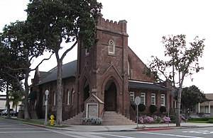
Fullerton First Methodist Episcopal Church
Historic church in California, United States
Distance: Approx. 811 meters
Latitude and longitude: 33.87138889,-117.92166667
Fullerton First Methodist Episcopal Church (also known as Seventh Day Adventist Church; Church of Religious Science) is a historic church building at 117 N. Pomona Avenue in Fullerton, California. By 2000 it was a Centers for Spiritual Living church. It was built in 1909 in the Late Gothic Revival style.

Amerige Park
Distance: Approx. 412 meters
Latitude and longitude: 33.869395,-117.929735
Amerige Park is a public park and multi-purpose athletic facility located at 300 West Commonwealth Avenue in Fullerton, California. It sits on the site of the former Fullerton High School. It was named for the city founders, George and Edward Amerige.

Fullerton Post Office
United States historic place
Distance: Approx. 252 meters
Latitude and longitude: 33.8675,-117.92555556
The Fullerton Post Office, better known as the Commonwealth Station, was built in 1939 by the Works Progress Administration, in Fullerton, Orange County, Southern California. Construction costs were $56,000 and took less than seven months to complete. The building was dedicated on November 1, 1938.

Fullerton City Hall
United States historic place
Distance: Approx. 730 meters
Latitude and longitude: 33.8725,-117.92944444
The historic Fullerton Police Station, formerly Fullerton City Hall, at 237 W. Commonwealth Ave. in Fullerton, California, was built during 1939 to 1942. It was designed in Mission Revival style by influential architect G. Stanley Wilson, and was made of poured concrete.
Orangefair Marketplace
Distance: Approx. 1006 meters
Latitude and longitude: 33.8578,-117.9234
Orangefair Marketplace is a community shopping center in Fullerton, California which when built was one of the earliest large shopping centers in Orange County, California. along with Anaheim Plaza and Orange County Plaza. It is located at the southeast corner of Harbor Boulevard (originally Spadra Road) and Orangethorpe Avenue, a mile south of Fullerton's historic downtown.
Weather in this IP's area
overcast clouds
15 Celsius
15 Celsius
14 Celsius
17 Celsius
1018 hPa
86 %
1018 hPa
1020 hPa
10000 meters
1.79 m/s
3.13 m/s
360 degree
100 %