66.11.156.130 - IP Lookup: Free IP Address Lookup, Postal Code Lookup, IP Location Lookup, IP ASN, Public IP
Country:
 Canada
Region:
City:
Location:
Time Zone:
Postal Code:
ISP:
ASN:
language:
User-Agent:
Proxy IP:
Blacklist:
IP information under different IP Channel
ip-api
Country
Region
City
ASN
Time Zone
ISP
Blacklist
Proxy
Latitude
Longitude
Postal
Route
db-ip
Country
Region
City
ASN
Time Zone
ISP
Blacklist
Proxy
Latitude
Longitude
Postal
Route
IPinfo
Country
Region
City
ASN
Time Zone
ISP
Blacklist
Proxy
Latitude
Longitude
Postal
Route
IP2Location
66.11.156.130Country
caRegion
british columbia
City
vancouver
Time Zone
America/Vancouver
ISP
Language
User-Agent
Latitude
Longitude
Postal
ipdata
Country
Region
City
ASN
Time Zone
ISP
Blacklist
Proxy
Latitude
Longitude
Postal
Route
Popular places and events near this IP address

Gastown
Neighbourhood in Vancouver, Canada
Distance: Approx. 174 meters
Latitude and longitude: 49.284688,-123.110953
Gastown is the original settlement that became the core of the city of Vancouver, British Columbia, Canada, and a national historic site and a neighbourhood in the northwest section of the Downtown Eastside, adjacent to Downtown Vancouver. Its historical boundaries – the waterfront (now Water Street and the CPR tracks), Carrall Street, Hastings Street, and Cambie Street – followed the borders of the 1870 townsite survey, the proper name and postal address of which was Granville, B.I. ("Burrard Inlet"). The official boundary does not include most of Hastings Street except for the Woodward's and Dominion Buildings, and stretches east past Columbia Street, to the laneway running parallel to the west side of Main Street.

Waterfront station (Vancouver)
Metro Vancouver public transportation facility
Distance: Approx. 274 meters
Latitude and longitude: 49.28583333,-123.11166667
Waterfront station is a major intermodal public transportation facility and the main transit terminus in Vancouver, British Columbia, Canada. It is on West Cordova Street in Downtown Vancouver, between Granville and Seymour Street. The station is also accessible via two other street-level entrances, one on Howe Street to the west for direct access to the Expo Line and another on Granville Street to the south for direct access to the Canada Line.

HarbourLynx
Canadian ferry company
Distance: Approx. 313 meters
Latitude and longitude: 49.28714,-123.10955
HarbourLynx was a private company based in Nanaimo, British Columbia that provided passenger-only high speed ferry service between the city centres of Nanaimo and Vancouver.

Woodward's Building
Historic commercial building in Vancouver, British Columbia, Canada
Distance: Approx. 253 meters
Latitude and longitude: 49.28227778,-123.10736111
The Woodward's Building is a historic building in the Downtown Eastside of Vancouver, British Columbia, Canada. The original portion of the building was constructed in 1903 for the Woodward's Department Store when that area of Cordova Street was the heart of Vancouver's retail shopping district. At one time, this was the premier shopping destination in Vancouver.

Dominion Building
Historic commercial building in Vancouver, British Columbia, Canada
Distance: Approx. 235 meters
Latitude and longitude: 49.2825,-123.11
The Dominion Building (originally Dominion Trust Building) is a commercial building in Vancouver, British Columbia, Canada. Located on the edge of Gastown (207 West Hastings St), it was Vancouver's first steel-framed high-rise. Its architect was John S. Helyer, who is said to have died after falling off the staircase in the front of the building, though this is an urban legend.

Harbour Centre
Mixed-use skyscraper in Vancouver, British Columbia
Distance: Approx. 270 meters
Latitude and longitude: 49.2846,-123.1123
Harbour Centre is a skyscraper in the central business district of Downtown Vancouver, British Columbia, Canada which opened in 1977. The "Lookout" tower atop the office building makes it one of the tallest structures in Vancouver and a prominent landmark on the city's skyline. With its 360-degree viewing deck, it also serves as a tourist attraction with the Top of Vancouver Revolving Restaurant, offering a physically unobstructed view of the city.

Victory Square, Vancouver
Park in Vancouver, Canada
Distance: Approx. 281 meters
Latitude and longitude: 49.2821,-123.1102
Victory Square is a park in Vancouver, British Columbia, Canada. The square is bordered by West Hastings Street to the northeast, West Pender Street to the southwest, Cambie Street to the southeast, and Hamilton Street to the northwest. The term is also used to refer to the neighbourhood immediately surrounding the square.
Whitecaps Waterfront Stadium
Distance: Approx. 239 meters
Latitude and longitude: 49.28555556,-123.10583333
The Whitecaps Waterfront Stadium was a proposed open-air soccer facility in Vancouver, British Columbia that would have been privately funded and developed by the Vancouver Whitecaps FC. The proposed location was north of Gastown on the central waterfront on what was then a parking lot and the site of a helicopter landing pad. The proposed stadium would have housed the Vancouver Whitecaps FC men and women's clubs.
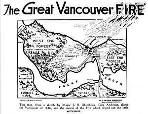
Great Vancouver Fire
1886 fire that burned down most of Vancouver, British Columbia, Canada
Distance: Approx. 238 meters
Latitude and longitude: 49.28316667,-123.11127778
The Great Vancouver Fire destroyed most of the newly incorporated city of Vancouver, British Columbia, Canada, on June 13, 1886. It started as two land-clearing fires to the west of the city. The first fire was farther away from the city and was clearing land for the roundhouse of the terminus of the Canadian Pacific Railway.
CPR Pier D
Port facility in Vancouver, Canada
Distance: Approx. 291 meters
Latitude and longitude: 49.2868,-123.1102
Pier D was a pier on the waterfront of Vancouver, Canada, built by the Canadian Pacific Railway. It was extended in 1916, with CPR committing $700,000 to the project, including $150,000 in what was described as "the largest piling contract ever given on the Pacific coast". The pier was burned to the ground on July 27, 1938, with losses assessed at $1,000,000.
New Image College
Private art school in Vancouver, Canada
Distance: Approx. 265 meters
Latitude and longitude: 49.284072,-123.112214
New Image College (commonly abbreviated as NIC) is a PTIB-accredited private academy for film acting, makeup artistry, aesthetics, hairdressing, and nail design located in downtown Vancouver, British Columbia. New Image College consists of two locations: their main student campus is located at Granville and Nelson and their corporate offices at Granville and Pender. New Image College is EQA-designated by the BC Ministry of Education, and a Designated Learning Institution with CIC. New Image College is a branch of the multimedia and venture capitalist corporation Global Model and Talent Inc., which is a multi-faceted organization comprising New Image Entertainment, LD Vacations, ShyDaTry Service and Product Inc., Phrike Film Festival, NIC Spa Inc.

Woodward's 43
Mixed-use skyscraper in Vancouver, British Columbia
Distance: Approx. 166 meters
Latitude and longitude: 49.28294444,-123.10808333
Woodward's 43, also known as W43 or the W Building, is a 122.3 m (401 ft) tall mixed-use skyscraper located in the Downtown Eastside of Vancouver, British Columbia, Canada.
Weather in this IP's area
broken clouds
4 Celsius
-3 Celsius
3 Celsius
4 Celsius
1005 hPa
83 %
1005 hPa
991 hPa
10000 meters
11.83 m/s
15.43 m/s
280 degree
75 %