Country:
Region:
City:
Latitude and Longitude:
Time Zone:
Postal Code:
IP information under different IP Channel
ip-api
Country
Region
City
ASN
Time Zone
ISP
Blacklist
Proxy
Latitude
Longitude
Postal
Route
Luminati
Country
Region
ny
City
cohoes
ASN
Time Zone
America/New_York
ISP
TVC-AS1
Latitude
Longitude
Postal
IPinfo
Country
Region
City
ASN
Time Zone
ISP
Blacklist
Proxy
Latitude
Longitude
Postal
Route
db-ip
Country
Region
City
ASN
Time Zone
ISP
Blacklist
Proxy
Latitude
Longitude
Postal
Route
ipdata
Country
Region
City
ASN
Time Zone
ISP
Blacklist
Proxy
Latitude
Longitude
Postal
Route
Popular places and events near this IP address

Niskayuna (CDP), New York
Census-designated place & hamlet in New York, United States
Distance: Approx. 2737 meters
Latitude and longitude: 42.81722222,-73.8975
Niskayuna is a hamlet (and census-designated place) in Schenectady County, New York, United States. The population was 20,787 at the 2020 census. The hamlet of Niskayuna is in the town of Niskayuna.
Niskayuna, New York
Town in New York, United States
Distance: Approx. 1804 meters
Latitude and longitude: 42.80027778,-73.88083333
Niskayuna is a town in Schenectady County, New York, United States. The population was 23,278 at the 2020 census. The town is located in the southeast part of the county, east of the city of Schenectady, and is the easternmost town in the county.

Niskayuna High School
Public school in Niskayuna, New York, United States
Distance: Approx. 2144 meters
Latitude and longitude: 42.81833333,-73.88944444
Niskayuna High School is a public high school in Niskayuna, New York, United States, and is the only high school operated by the Niskayuna Central School District.
Schenectady High School
Urban public high school
Distance: Approx. 3693 meters
Latitude and longitude: 42.814,-73.91
Schenectady High School is a high school located at 1445 The Plaza in Schenectady, New York, USA. It was founded in 1992 through the merger of Linton High School and Mont Pleasant High School. It is the only high school in the Schenectady City School District. Among the programs at SHS are the International Baccalaureate Program and the CISCO program.

Vischer Ferry, New York
Hamlet in New York, United States
Distance: Approx. 3383 meters
Latitude and longitude: 42.79722222,-73.82833333
Vischer Ferry is a hamlet in the town of Clifton Park in Saratoga County, New York, United States, along the Mohawk River.

Grooms Tavern Complex
Historic commercial building in New York, United States
Distance: Approx. 3065 meters
Latitude and longitude: 42.83472222,-73.84472222
Grooms Tavern Complex is a historic tavern located at Grooms Corners in Saratoga County, New York. The complex consists of the tavern, a wagon and blacksmith shop, and a frame privy. The tavern building was built about 1825 and is a 2-story, timber-framed, gable-roofed building in a vernacular Federal style.
George Westinghouse Jones House
Historic house in New York, United States
Distance: Approx. 2608 meters
Latitude and longitude: 42.79416667,-73.88638889
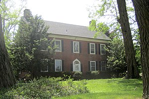
George Westinghouse Jones House, also known by the Welsh name of Caermarthen, is a historic home located in the Town of Niskayuna in Schenectady County, New York. It was built about 1900 and designed by the architectural firm of Rutan & Russell. It is a rambling, 2+1⁄2-story gable-roofed frame residence in the Shingle Style.
Rosendale Common School
United States historic place
Distance: Approx. 1788 meters
Latitude and longitude: 42.79611111,-73.85861111
Rosendale Common School, also known as Niskayuna Grange Hall No. 1542, is a historic school building located in the vicinity of Niskayuna in Schenectady County, New York. It was built about 1850 and is a 1+1⁄2-story, three-by-five-bay, timber-frame building on a limestone foundation.

Abraham Best House
Historic house in New York, United States
Distance: Approx. 3169 meters
Latitude and longitude: 42.81222222,-73.82611111
The Abraham Best House is a historic house located at 113 Vischer Ferry Road near Vischer Ferry, Saratoga County, New York.

Mohawk Valley Grange Hall
United States historic place
Distance: Approx. 2988 meters
Latitude and longitude: 42.83333333,-73.84361111
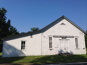
Mohawk Valley Grange Hall, also known as Union Hall and Moser Hall, is a historic Grange hall located near Grooms Corners, Saratoga County, New York. It was built in 1896, and is a 1 1/2-story, three bay by four bay, timber frame building. It sits on a dry lad stone foundation and has a steep gable roof.
Mohawk River State Park
Nature preserve in New York, United States
Distance: Approx. 1404 meters
Latitude and longitude: 42.8036,-73.8515
Mohawk River Nature Preserve, formerly Mohawk River State Park, is a 105-acre (0.42 km2) undeveloped nature preserve in the town of Niskayuna in Schenectady County, New York. The park is located adjacent to the Mohawk River.
Stony Creek (Mohawk River tributary)
River in New York, United States
Distance: Approx. 3350 meters
Latitude and longitude: 42.79444444,-73.83111111
Stony Creek is a river that flows into the Mohawk River in Vischer Ferry, New York.
Weather in this IP's area
clear sky
5 Celsius
3 Celsius
4 Celsius
6 Celsius
1033 hPa
67 %
1033 hPa
1021 hPa
10000 meters
1.79 m/s
4.47 m/s
48 degree
06:32:42
16:45:17
