66.102.18.137 - IP Lookup: Free IP Address Lookup, Postal Code Lookup, IP Location Lookup, IP ASN, Public IP
Country:
 USA
USARegion:
City:
Location:
Time Zone:
Postal Code:
ISP:
ASN:
language:
User-Agent:
Proxy IP:
Blacklist:
IP information under different IP Channel
ip-api
Country
Region
City
ASN
Time Zone
ISP
Blacklist
Proxy
Latitude
Longitude
Postal
Route
db-ip
Country
Region
City
ASN
Time Zone
ISP
Blacklist
Proxy
Latitude
Longitude
Postal
Route
IPinfo
Country
Region
City
ASN
Time Zone
ISP
Blacklist
Proxy
Latitude
Longitude
Postal
Route
IP2Location
66.102.18.137Country
usRegion
texas
City
pasadena
Time Zone
America/Chicago
ISP
Language
User-Agent
Latitude
Longitude
Postal
ipdata
Country
Region
City
ASN
Time Zone
ISP
Blacklist
Proxy
Latitude
Longitude
Postal
Route
Popular places and events near this IP address

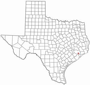
Pasadena, Texas
City in Texas, United States
Distance: Approx. 3089 meters
Latitude and longitude: 29.67611111,-95.17388889
Pasadena () is a city in the U.S. state of Texas, located in Harris County. It is part of the Houston–The Woodlands–Sugar Land metropolitan area. As of the 2020 U.S. census, the city's population was 151,950, making it the 23rd most populous city in Texas and the second most populous in Harris County, after Houston.

South Houston, Texas
City in Texas, United States
Distance: Approx. 4528 meters
Latitude and longitude: 29.66111111,-95.22972222
South Houston is a city in the U.S. state of Texas, within Houston–The Woodlands–Sugar Land metropolitan area and Harris County. The population was 16,153 at the 2020 census. It is bordered by the cities of Houston and Pasadena, and geographically located southeast of Houston.
Allen Ranch
Ranch in Texas, US
Distance: Approx. 3089 meters
Latitude and longitude: 29.67611111,-95.17388889
The Allen Ranch, or Sam Allen Ranch, was one of the first and longest running ranches in the history of the state of Texas in the United States. The ranch was started a few years after the Texas Revolution in what is now southeast Houston and Pasadena. The ranch itself extended from Clear Lake to Harrisburg (in modern east Houston).

Texas's 29th congressional district
U.S. House district for Texas
Distance: Approx. 4479 meters
Latitude and longitude: 29.68805556,-95.19972222
Texas's 29th congressional district of the United States House of Representatives covers the eastern portion of the Greater Houston area in the state of Texas. The current Representative from the 29th district is Democrat Sylvia Garcia. The Texas State Legislature established the district as a majority-Hispanic or Latino district.

Pasadena Independent School District
School district in Texas
Distance: Approx. 3177 meters
Latitude and longitude: 29.6779,-95.1916
Pasadena Independent School District is a school district that is based in Pasadena, Texas, United States. Pasadena ISD serves much of southeast Harris County. The district includes most of Pasadena, South Houston, a portion of Houston (including Genoa), and a portion of Pearland.
YES College Prep Southeast
State charter school in the United States
Distance: Approx. 2463 meters
Latitude and longitude: 29.639428,-95.207058
YES Prep Southeast is a school in Houston, Texas. The mascot is Wizards. In 2007, it ranked #40 on Newsweek Magazine's Top 100 High Schools list and it was also ranked #38 by U.S News.

Pasadena Memorial High School
School in Pasadena, Texas, United States
Distance: Approx. 1546 meters
Latitude and longitude: 29.6391,-95.1748
Pasadena Memorial High School (PMHS) is a secondary school located in Pasadena, Texas. The school serves grades 9 through 12 and is the second-largest school in the Pasadena Independent School District. It is sometimes referred to simply as "Memorial" or as "PMHS" to differentiate it from nearby Pasadena High School.

South Houston High School
Public school in South Houston, Texas, United States
Distance: Approx. 2442 meters
Latitude and longitude: 29.65206,-95.20983
South Houston High School is a public high school located in South Houston, Texas in the United States. The school is a part of the Pasadena Independent School District.

Sam Rayburn High School
Public school in Pasadena, Texas, United States
Distance: Approx. 3178 meters
Latitude and longitude: 29.67848,-95.1824
Sam Rayburn High School is a public high school located in Pasadena, Texas in the United States. The school is a part of the Pasadena Independent School District.
Vince Bayou
River in the United States
Distance: Approx. 2373 meters
Latitude and longitude: 29.66666667,-95.2
Vince Bayou, also known as Vince's Bayou, is a river that rises in southeast Harris County, Texas and runs northwest, through Pasadena and the city of South Houston, for a total of 19 channel miles (which include the reach of one minor tributary) to its mouth on the Houston Ship Channel (the lower reaches of Buffalo Bayou). Very little wildlife habitat exists, and the estimated population within the Vince Bayou watershed is just under 89,000 persons. Vince Bayou hosts a primarily urban environment.
Verne Cox Multipurpose Recreation Center
Recreation center in Pasadena, Texas
Distance: Approx. 2042 meters
Latitude and longitude: 29.63182,-95.18187
The Verne Cox Multipurpose Recreation Center is a recreation center located in Pasadena, Texas. The center provides recreational programs, events, and services for Pasadena's youth and adults with cognitive or physical disabilities. The Verne Cox Center is a division of the Parks & Recreation Department of the City of Pasadena.
Texas Chiropractic College
Distance: Approx. 3723 meters
Latitude and longitude: 29.664102,-95.149801
Texas Chiropractic College (TCC) is a private chiropractic college in Pasadena, Texas. Founded in 1908, it is the fourth-oldest chiropractic college in the United States. TCC was originally located in San Antonio, Texas before moving in 1965 to Pasadena due to increased demands for a larger campus.
Weather in this IP's area
clear sky
12 Celsius
12 Celsius
11 Celsius
13 Celsius
1022 hPa
88 %
1022 hPa
1020 hPa
10000 meters
2.06 m/s
140 degree