65.65.152.94 - IP Lookup: Free IP Address Lookup, Postal Code Lookup, IP Location Lookup, IP ASN, Public IP
Country:
Region:
City:
Location:
Time Zone:
Postal Code:
ISP:
ASN:
language:
User-Agent:
Proxy IP:
Blacklist:
IP information under different IP Channel
ip-api
Country
Region
City
ASN
Time Zone
ISP
Blacklist
Proxy
Latitude
Longitude
Postal
Route
db-ip
Country
Region
City
ASN
Time Zone
ISP
Blacklist
Proxy
Latitude
Longitude
Postal
Route
IPinfo
Country
Region
City
ASN
Time Zone
ISP
Blacklist
Proxy
Latitude
Longitude
Postal
Route
IP2Location
65.65.152.94Country
Region
texas
City
alpine
Time Zone
America/Chicago
ISP
Language
User-Agent
Latitude
Longitude
Postal
ipdata
Country
Region
City
ASN
Time Zone
ISP
Blacklist
Proxy
Latitude
Longitude
Postal
Route
Popular places and events near this IP address
Alpine, Texas
City in Texas, United States
Distance: Approx. 2776 meters
Latitude and longitude: 30.37222222,-103.66666667
Alpine ( AL-pyne) is a city in and the county seat of Brewster County, Texas, United States. The population was 6,035 at the 2020 census. The town has an elevation of 4,462 feet (1,360 m), and the surrounding mountain peaks are over 1 mile (1.6 km) above sea level.
Sul Ross State University
Public university in Alpine, Texas
Distance: Approx. 1862 meters
Latitude and longitude: 30.36333333,-103.65
Sul Ross State University (SRSU) is a public university in Alpine, Texas, United States. The main campus is the primary institution of higher education serving the nineteen-county Big Bend region of far West Texas. Branch campuses, branded as Rio Grande College, are located in Del Rio, Uvalde, Eagle Pass, and Castroville.

Alpine station
Amtrak station in Alpine, Texas
Distance: Approx. 1037 meters
Latitude and longitude: 30.3572,-103.66168
Alpine station is an Amtrak station in Alpine, Texas, served by the Sunset Limited and Texas Eagle routes. It is not staffed and has partial wheelchair accessibility, an enclosed waiting area, public payphones, and parking. It is located at 102 West Holland Street, is less than 1 mile (1.6 km) from Sul Ross State University, and is also the nearest station to Big Bend National Park.
Alpine–Casparis Municipal Airport
Airport in Texas, United States of America
Distance: Approx. 4771 meters
Latitude and longitude: 30.38673,-103.6805
Alpine–Casparis Municipal Airport (IATA: ALE, FAA LID: E38) is a city-owned public-use airport located 2 miles (3.2 km) northwest of the central business district of Alpine, a city in Brewster County, Texas, United States. It supports two small runways and is not meant for large commercial planes. Alpine-Casparis is the only airport in Brewster County.
Texas Davis Mountains AVA
Distance: Approx. 8752 meters
Latitude and longitude: 30.363,-103.569
The Texas Davis Mountains AVA is an American Viticultural Area located in the Trans-Pecos region of West Texas. Surrounded by the Chihuahuan Desert, the appellation takes advantage of cooler elevation and lower annual rainfall in the Davis Mountains. The land within the boundaries of the AVA ranges between 4,500 feet (1,372 m) and 8,300 feet (2,530 m) above sea level.

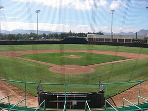
Kokernot Field
Baseball stadium in Alpine, Texas
Distance: Approx. 2809 meters
Latitude and longitude: 30.373,-103.6645
Kokernot Field is a baseball stadium in Alpine, Texas, USA. The field has been called "The Best Little Ballpark in Texas (or Anywhere Else)" by Sports Illustrated and the "Yankee Stadium of Texas" by Texas Monthly magazine. An estimated 6,000 attended a 1951 exhibition featuring Satchel Paige's St. Louis Browns versus the Chicago White Sox.
1995 Marathon earthquake
Earthquake in Texas, United States
Distance: Approx. 1096 meters
Latitude and longitude: 30.35805556,-103.66
Striking on April 13, 1995, the 1995 Marathon earthquake was recorded at moment magnitude of 5.7. It rattled buildings near the epicenter.

Arlington Southwest
American war memorial in Texas
Distance: Approx. 6848 meters
Latitude and longitude: 30.382668,-103.59937
Arlington Southwest is an unoccupied cemetery located in Brewster County, Texas, 4 miles (6.4 km) east of Alpine along U.S. Highway 90. Each gravestone serves as a memorial for each individual soldier from Texas killed during the invasion and occupation of Iraq of the early 21st century. Developed by the Big Bend Veterans for Peace, Arlington Southwest is believed to be the first permanent memorial dedicated to those fallen in the war similar to those established as the temporary Arlington West memorials in California in 2003.

Alpine High School
Public school in Alpine, Texas, United States
Distance: Approx. 2676 meters
Latitude and longitude: 30.371503,-103.665788
Alpine High School is a public high school located in the city of Alpine, Texas (USA) and is classified as a 3A school by the UIL. It is a part of the Alpine Independent School District located in north-central Brewster County. For the 2021-2022 school year, the school was given an "A" by the Texas Education Agency.

The Holland Hotel
Distance: Approx. 1104 meters
Latitude and longitude: 30.3575,-103.66277778
The Holland Hotel is a hotel in Alpine, Texas that has been operating since 1912. The hotel was built by Mr. John R. Holland, a prominent cattleman at the time.
KVLF (AM)
Radio station in Alpine, Texas
Distance: Approx. 2881 meters
Latitude and longitude: 30.374,-103.662
KVLF (1240 kHz) is an AM radio station in Alpine, Texas.
Weather in this IP's area
clear sky
-1 Celsius
-1 Celsius
-1 Celsius
-1 Celsius
1023 hPa
51 %
1023 hPa
854 hPa
10000 meters
0.89 m/s
0.83 m/s
120 degree
