65.61.1.54 - IP Lookup: Free IP Address Lookup, Postal Code Lookup, IP Location Lookup, IP ASN, Public IP
Country:
Region:
City:
Location:
Time Zone:
Postal Code:
ISP:
ASN:
language:
User-Agent:
Proxy IP:
Blacklist:
IP information under different IP Channel
ip-api
Country
Region
City
ASN
Time Zone
ISP
Blacklist
Proxy
Latitude
Longitude
Postal
Route
db-ip
Country
Region
City
ASN
Time Zone
ISP
Blacklist
Proxy
Latitude
Longitude
Postal
Route
IPinfo
Country
Region
City
ASN
Time Zone
ISP
Blacklist
Proxy
Latitude
Longitude
Postal
Route
IP2Location
65.61.1.54Country
Region
pennsylvania
City
harrisburg
Time Zone
America/New_York
ISP
Language
User-Agent
Latitude
Longitude
Postal
ipdata
Country
Region
City
ASN
Time Zone
ISP
Blacklist
Proxy
Latitude
Longitude
Postal
Route
Popular places and events near this IP address

Lawnton, Pennsylvania
Census-designated place in Pennsylvania, United States
Distance: Approx. 1024 meters
Latitude and longitude: 40.26138889,-76.80305556
Lawnton is an unincorporated area and census-designated place (CDP) in Swatara Township, Dauphin County, Pennsylvania, United States. The population was 3,813 at the 2010 census. It is part of the Harrisburg–Carlisle Metropolitan Statistical Area.
Paxtang, Pennsylvania
Borough in Pennsylvania, United States
Distance: Approx. 2636 meters
Latitude and longitude: 40.26083333,-76.83388889
Paxtang is a borough in Dauphin County, Pennsylvania, United States. As of the 2020 census it had a population of 1,640. The borough is a suburb of Harrisburg and is one of the earliest colonial settlements in South Central Pennsylvania.
Swatara Township, Dauphin County, Pennsylvania
Township in Pennsylvania, United States
Distance: Approx. 2481 meters
Latitude and longitude: 40.24972222,-76.81638889
Swatara Township is a township in Dauphin County, Pennsylvania. The population was 27,824 at the 2020 census.
Roman Catholic Diocese of Harrisburg
Latin Catholic ecclesiastical jurisdiction in Pennsylvania, USA
Distance: Approx. 1250 meters
Latitude and longitude: 40.28116,-76.8013
The Diocese of Harrisburg (Latin: Diœcesis Harrisburgensis) is a Latin Church ecclesiastical territory, or diocese, of the Catholic Church in south central Pennsylvania in the United States. It is a suffragan diocese of the metropolitan Archdiocese of Philadelphia. The mother church is St.

The Circle School
School in Harrisburg, Pennsylvania, US
Distance: Approx. 2098 meters
Latitude and longitude: 40.273399,-76.829887
The Circle School is a self-directed democratic school located in Harrisburg, Pennsylvania, founded in 1984. It is operated similarly to the Sudbury Valley School (Framingham, Massachusetts) and Hudson Valley Sudbury School (Kingston, New York). It enrolls pre-kindergarten through high school aged children.

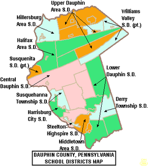
Central Dauphin School District
School district in Pennsylvania
Distance: Approx. 1576 meters
Latitude and longitude: 40.2842,-76.80138
The Central Dauphin School District is a large, suburban, public school district located in suburban Harrisburg, Pennsylvania serving students in central and eastern Dauphin County. It is the largest school district in the county, the largest in the greater Harrisburg metropolitan area and is the 9th largest school district in Pennsylvania. The district serves the Boroughs of: Dauphin, Paxtang and Penbrook as well as Lower Paxton Township, Middle Paxton Township, Swatara Township and West Hanover Township.
Chambers Hill, Pennsylvania
Community in Pennsylvania, U.S.
Distance: Approx. 677 meters
Latitude and longitude: 40.266,-76.811
Chambers Hill is a community in Swatara Township in Dauphin County, Pennsylvania. It is located in the area between 40 degrees 15'41 North and 76 degrees 48'42 West, between Harrisburg and Hershey. With ranges in elevation from 415–660 feet a view of the Harrisburg skyline to the west, or Three Mile Island to the south, can often be seen.

Central Dauphin East High School
Public high school in Harrisburg, Pennsylvania
Distance: Approx. 1653 meters
Latitude and longitude: 40.2846,-76.7998
Central Dauphin East High School is a large, suburban, public high school located in Harrisburg, Dauphin County, Pennsylvania. It is one of two high schools operated by the Central Dauphin School District. In the 2022–2023 school year, enrollment was reported as 1,590 pupils in 9th through 12th grades.
Bishop McDevitt High School (Harrisburg, Pennsylvania)
Private high school in Harrisburg, Pennsylvania, United States
Distance: Approx. 1279 meters
Latitude and longitude: 40.27494444,-76.79166667
Bishop McDevitt High School is a private, Roman Catholic, co-educational high school in Lower Paxton Township, Pennsylvania, United States. It was founded in 1918 as "Catholic High School" in Harrisburg and renamed in 1957 to honor the memory of the Most Reverend Philip R. McDevitt, fourth bishop of Harrisburg and founder of the school. It is located in the Roman Catholic Diocese of Harrisburg.

Paxtang Park
Trailhead area in Pennsylvania, US
Distance: Approx. 2751 meters
Latitude and longitude: 40.2562,-76.832
Paxtang Park is a hiking and mountain biking park in East Harrisburg, Pennsylvania and Paxtang, Pennsylvania. It is a part of the Capital Area Greenbelt. It was formerly a 40-acre (160,000 m2) trolley park.
Rutherford Intermodal Yard
Distance: Approx. 1977 meters
Latitude and longitude: 40.262,-76.785
Rutherford Intermodal Yard is a large rail yard located in Swatara Township, Dauphin County, just east of Harrisburg, Pennsylvania.
Oakleigh, Pennsylvania
Unincorporated community in Pennsylvania, U.S.
Distance: Approx. 1908 meters
Latitude and longitude: 40.258,-76.821
Oakleigh is an unincorporated community in Dauphin County, Pennsylvania. It is part of the Harrisburg–Carlisle metropolitan statistical area. Oakleigh is located on the intersection of Fortieth Street (Francis L. Cadden Parkway) and Derry Street in Swatara Township.
Weather in this IP's area
broken clouds
-7 Celsius
-14 Celsius
-7 Celsius
-7 Celsius
1014 hPa
85 %
1014 hPa
994 hPa
10000 meters
5.03 m/s
11.56 m/s
322 degree
57 %


