65.5.119.105 - IP Lookup: Free IP Address Lookup, Postal Code Lookup, IP Location Lookup, IP ASN, Public IP
Country:
Region:
City:
Location:
Time Zone:
Postal Code:
ISP:
ASN:
language:
User-Agent:
Proxy IP:
Blacklist:
IP information under different IP Channel
ip-api
Country
Region
City
ASN
Time Zone
ISP
Blacklist
Proxy
Latitude
Longitude
Postal
Route
db-ip
Country
Region
City
ASN
Time Zone
ISP
Blacklist
Proxy
Latitude
Longitude
Postal
Route
IPinfo
Country
Region
City
ASN
Time Zone
ISP
Blacklist
Proxy
Latitude
Longitude
Postal
Route
IP2Location
65.5.119.105Country
Region
mississippi
City
west point
Time Zone
America/Chicago
ISP
Language
User-Agent
Latitude
Longitude
Postal
ipdata
Country
Region
City
ASN
Time Zone
ISP
Blacklist
Proxy
Latitude
Longitude
Postal
Route
Popular places and events near this IP address

West Point, Mississippi
City in Mississippi, United States
Distance: Approx. 2834 meters
Latitude and longitude: 33.60611111,-88.6525
West Point is a city in Clay County, Mississippi, United States, in the Golden Triangle region of the state. The population was 10,105 at the 2020 census. It is the county seat of Clay County and the principal city of the West Point Micropolitan Statistical Area, which is part of the larger Columbus-West Point Combined Statistical Area.

Golden Triangle (Mississippi)
Region in east-central Mississippi, United States
Distance: Approx. 9736 meters
Latitude and longitude: 33.54219,-88.660831
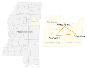
The Golden Triangle (GTR) is a region in the east central portion of the U.S. state of Mississippi. The "triangle" is formed by the cities of Columbus, Starkville, and West Point but the region is often more broadly-defined to include all of Clay, Lowndes, and Oktibbeha counties and sometimes additional surrounding communities and counties as well. The term was used as a marketing strategy in the 1960s to promote economic development in the region and encourage additional cooperation between local communities in attracting investment, although the term was in use by 1939.
Strong, Mississippi
Unincorporated community in Mississippi, United States
Distance: Approx. 9177 meters
Latitude and longitude: 33.69527778,-88.60444444
Strong (also known as Strongs or Strongs Station) is an unincorporated community in Monroe County, Mississippi, United States. Strong is located southwest of Aberdeen.

WACR-FM
Radio station in Columbus (Air Force Base), Mississippi
Distance: Approx. 4425 meters
Latitude and longitude: 33.66916667,-88.66888889
WACR-FM (105.3 FM) is a radio station licensed to Columbus Air Force Base, United States. The station is currently owned by URBan Radio Broadcasting, through licensee GTR Licenses, LLC, and broadcasts an Urban Adult Contemporary format.
White Station, Mississippi
Unincorporated community in Mississippi, United States
Distance: Approx. 5281 meters
Latitude and longitude: 33.66027778,-88.62083333
White Station (also known as White or Whites) is a small unincorporated community located in Clay County, Mississippi, United States. The community is north of West Point. White Station is the birthplace of blues musician Howlin' Wolf.

Payne Field
Former World War I military airfield
Distance: Approx. 4241 meters
Latitude and longitude: 33.66555556,-88.64916667
Payne Field is a former World War I military airfield, located 4.3 miles (6.9 km) north-northeast of West Point, Mississippi. It operated as a training field for the United States Army Air Service between 1918 until 1920. The airfield was one of thirty-two Air Service training camps established in 1917 after the United States entry into World War I. It was the first airport constructed in Mississippi.
WSMS
Radio station in Artesia, Mississippi
Distance: Approx. 4852 meters
Latitude and longitude: 33.65388889,-88.62083333
WSMS (99.9 FM, "The Fox") is a Mississippi based radio station broadcasting an album-oriented rock (AOR) music format. Licensed to Artesia, Mississippi, United States, the station serves the Columbus-Starkville-West Point area. The station is currently owned by Cumulus Media and features programming from Westwood One.
1999 U.S. Women's Open
Golf tournament
Distance: Approx. 8012 meters
Latitude and longitude: 33.575,-88.608
The 1999 U.S. Women's Open was the 54th U.S. Women's Open, held June 3–6 at Old Waverly Golf Club in West Point, Mississippi, northwest of Columbus. In her twentieth attempt, Juli Inkster won the first of her two U.S. Women's Open titles, five strokes ahead of runner-up Sherri Turner. Inkster, 38, broke the under-par scoring record with a 272 (−16) and became the oldest champion since 1955.
Old Waverly Golf Club
Distance: Approx. 8120 meters
Latitude and longitude: 33.574302,-88.607192
Old Waverly Golf Club, located in West Point, Mississippi, is an 18-hole championship golf course founded by the George Bryan family and 29 other founders in 1988. Designed by U.S. Open Champion Jerry Pate and Bob Cupp, Old Waverly has hosted many tournaments across all levels of golf, most notably the 1999 U.S. Women's Open and 2019 U.S. Women's Amateur. Old Waverly's second course, Mossy Oak Golf Club, was designed by Gil Hanse and opened September 2, 2016 on an adjacent property.
Oak Hill Academy (Mississippi)
School in West Point, Mississippi, United States
Distance: Approx. 3163 meters
Latitude and longitude: 33.6167,-88.6339
Oak Hill Academy is a private PK-12 school in West Point, Mississippi, the seat of Clay County, Mississippi. The school serves about 400 students. It was founded as a segregation academy in 1966.
Chuquatonchee Creek
Natural watercourse in Clay County, Mississippi, United States of America
Distance: Approx. 7413 meters
Latitude and longitude: 33.56861111,-88.69638889
Chuquatonchee Creek is a stream in Chickasaw, Clay and Pontotoc counties in the U.S. state of Mississippi. It is a tributary to Tibbee Creek.
Muldrow, Mississippi
Unincorporated community in Mississippi, United States
Distance: Approx. 9954 meters
Latitude and longitude: 33.54666667,-88.70444444
Muldrow is an unincorporated community in Oktibbeha County, Mississippi, United States, located northeast of Starkville and southwest of West Point.
Weather in this IP's area
broken clouds
1 Celsius
-2 Celsius
0 Celsius
4 Celsius
1030 hPa
69 %
1030 hPa
1020 hPa
10000 meters
3.12 m/s
5.48 m/s
162 degree
79 %