65.5.118.27 - IP Lookup: Free IP Address Lookup, Postal Code Lookup, IP Location Lookup, IP ASN, Public IP
Country:
Region:
City:
Location:
Time Zone:
Postal Code:
ISP:
ASN:
language:
User-Agent:
Proxy IP:
Blacklist:
IP information under different IP Channel
ip-api
Country
Region
City
ASN
Time Zone
ISP
Blacklist
Proxy
Latitude
Longitude
Postal
Route
db-ip
Country
Region
City
ASN
Time Zone
ISP
Blacklist
Proxy
Latitude
Longitude
Postal
Route
IPinfo
Country
Region
City
ASN
Time Zone
ISP
Blacklist
Proxy
Latitude
Longitude
Postal
Route
IP2Location
65.5.118.27Country
Region
mississippi
City
laurel
Time Zone
America/Chicago
ISP
Language
User-Agent
Latitude
Longitude
Postal
ipdata
Country
Region
City
ASN
Time Zone
ISP
Blacklist
Proxy
Latitude
Longitude
Postal
Route
Popular places and events near this IP address

Laurel, Mississippi
City in Mississippi, United States
Distance: Approx. 3804 meters
Latitude and longitude: 31.6975,-89.13944444
Laurel is a city in and the second county seat of Jones County, Mississippi, United States. As of the 2020 census, the city had a population of 17,161. Laurel is northeast of Ellisville, the first county seat, which contains the first county courthouse.

Laurel station (Mississippi)
Train station in Laurel, Mississippi, US
Distance: Approx. 3174 meters
Latitude and longitude: 31.6922,-89.128
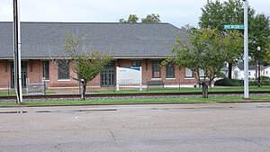
Laurel station is an Amtrak station at 230 North Maple Street in the heart of downtown Laurel, Mississippi. Currently served by Amtrak's Crescent passenger train, the station was originally built in 1913 by the New Orleans and Northeastern Railroad, which was acquired in 1916 by the Southern Railway. The station is a Mississippi Landmark and has been listed on the National Register of Historic Places since October 31, 1995.
Laurel Christian School
Private school in the United States
Distance: Approx. 4659 meters
Latitude and longitude: 31.7050589,-89.1510787
Laurel Christian School is a private, college preparatory Christian school founded in 1982. It is located in Laurel, Mississippi, in the United States.
South Central Regional Medical Center
Hospital in Mississippi, U.S.
Distance: Approx. 4604 meters
Latitude and longitude: 31.68516,-89.14072
South Central Regional Medical Center was founded in 1952 and is currently a 285-bed, public not-for-profit hospital located in Laurel, Mississippi. The hospital primarily serves a four-county area: Jones County, Jasper County, Wayne County and Smith County. The stated focus of the South Central Regional Medical Center Health System is to provide excellent healthcare services to the residents of South Central Mississippi and to improve the quality of life in the region.

Laurel micropolitan area
Micropolitan Statistical Area in Mississippi, United States
Distance: Approx. 3211 meters
Latitude and longitude: 31.709021,-89.136157
The Laurel Micropolitan Statistical Area is a micropolitan statistical area (μSA) in southeastern Mississippi that covers two counties - Jasper and Jones. The 2010 census placed the Laurel micropolitan area population at 84,823, though as of 2019, estimates indicate the population has slightly decreased to 84,481.
Southeastern Baptist College
Distance: Approx. 6148 meters
Latitude and longitude: 31.748472,-89.149451
Southeastern Baptist College is a private Baptist Bible college in Laurel, Mississippi. Founded in 1948, it offers both a 4-year Bachelor's degree program and a 2-year curriculum. The college is accredited at the state level by the Mississippi Commission on Accreditation and by the Association For Biblical Higher Education (ABHE) on the national level.

Errata, Mississippi
Unincorporated community in Mississippi, United States
Distance: Approx. 6712 meters
Latitude and longitude: 31.75888889,-89.06
Errata (also spelled Erata) is an unincorporated community in Jones County, Mississippi. Errata is located on U.S. Route 11 2.5 miles (4.0 km) southwest of Sandersville. Errata is located on the Norfolk Southern Railway and was once home to nine different sawmills and a grocery store.

Lauren Rogers Museum of Art
Art museum in Mississippi, United States
Distance: Approx. 3122 meters
Latitude and longitude: 31.696348,-89.130763
Mississippi's first art museum, the Lauren Rogers Museum of Art is located in Laurel, Mississippi, United States. It was founded in 1923 in memory of Lauren Eastman Rogers. The museum has an extensive collection of Native American baskets.
Laurel High School (Mississippi)
Public high school in Laurel, Mississippi
Distance: Approx. 3644 meters
Latitude and longitude: 31.70361111,-89.13991667
Laurel High School is a public school in Laurel, Mississippi, United States, part of the Laurel School District. The school provides education to grades 9–12. In 2022, the school's enrollment was documented at about 710 with 87 percent African American, 8 percent hispanic, and 3 percent white.
Bogue Cheely
Stream in Mississippi, U.S.
Distance: Approx. 6902 meters
Latitude and longitude: 31.7076616,-89.0294987
Bogue Cheely is a stream in the U.S. state of Mississippi. Bogue Cheely is a name derived from the Choctaw language most likely meaning "branch or branches of a creek".

Newell Rogers House
United States historic place
Distance: Approx. 3327 meters
Latitude and longitude: 31.69694444,-89.13361111
The Newell Rogers House, also known as the R. C. Gaddis House, is a historic two-story house in Laurel, Mississippi. It was designed in an eclectic architectural style with Neoclassical and Mediterranean features by DeBuys, Churchill & Labouisse, and built in 1909 for George S. Gardiner for his daughter Juliet Gardiner and her husband Newell Rogers. It was later purchased by R. C. Gaddis, followed by Thomas Saucier.
Northeast Jones High School
Public secondary school in Laurel, Mississippi, United States
Distance: Approx. 5060 meters
Latitude and longitude: 31.695843,-89.051724
Northeast Jones High School (NEJ) is a public high school located in Jones County, Mississippi, United States, near the city of Laurel. Northeast Jones serves students in grades 7 through 12 and is one of three traditional high schools in the Jones County School District.
Weather in this IP's area
overcast clouds
6 Celsius
6 Celsius
6 Celsius
6 Celsius
1030 hPa
75 %
1030 hPa
1019 hPa
10000 meters
100 %