65.49.147.133 - IP Lookup: Free IP Address Lookup, Postal Code Lookup, IP Location Lookup, IP ASN, Public IP
Country:
Region:
City:
Location:
Time Zone:
Postal Code:
ISP:
ASN:
language:
User-Agent:
Proxy IP:
Blacklist:
IP information under different IP Channel
ip-api
Country
Region
City
ASN
Time Zone
ISP
Blacklist
Proxy
Latitude
Longitude
Postal
Route
db-ip
Country
Region
City
ASN
Time Zone
ISP
Blacklist
Proxy
Latitude
Longitude
Postal
Route
IPinfo
Country
Region
City
ASN
Time Zone
ISP
Blacklist
Proxy
Latitude
Longitude
Postal
Route
IP2Location
65.49.147.133Country
Region
michigan
City
kalamazoo
Time Zone
America/Detroit
ISP
Language
User-Agent
Latitude
Longitude
Postal
ipdata
Country
Region
City
ASN
Time Zone
ISP
Blacklist
Proxy
Latitude
Longitude
Postal
Route
Popular places and events near this IP address
Kalamazoo College
Private liberal arts college in Kalamazoo, Michigan, U.S.
Distance: Approx. 1296 meters
Latitude and longitude: 42.29,-85.601
Kalamazoo College is a private liberal arts college in Kalamazoo, Michigan. Founded in 1833 by Baptist ministers as the Michigan and Huron Institute, Kalamazoo is the oldest private college in Michigan. From 1840 to 1850, the institute operated as the Kalamazoo Branch of the University of Michigan.

Waldo Stadium
Sports stadium in Kalamazoo, Michigan
Distance: Approx. 1723 meters
Latitude and longitude: 42.28583333,-85.60111111
Waldo Stadium is a stadium in Kalamazoo, Michigan. It is primarily used for football, and has been the home of Western Michigan University Broncos football in rudimentary form since 1914, and as a complete stadium since 1939. It currently has a capacity of 36,361 spectators.

Roman Catholic Diocese of Kalamazoo
Latin Catholic ecclesiastical jurisdiction in Michigan, USA
Distance: Approx. 1668 meters
Latitude and longitude: 42.29166667,-85.59144444
The Diocese of Kalamazoo (Latin: Dioecesis Kalamazuensis) is a Latin Church ecclesiastical territory, or diocese, of the Catholic Church in southwestern Michigan in the United States. It is a suffragan diocese in the ecclesiastical province of the metropolitan Archdiocese of Detroit. The mother church of the Diocese of Kalamazoo is the Cathedral of Saint Augustine in Kalamazoo.

Cathedral of Saint Augustine (Kalamazoo, Michigan)
Church in Michigan, United States
Distance: Approx. 1622 meters
Latitude and longitude: 42.2919,-85.5919
Cathedral of Saint Augustine (or St. Augustine Cathedral) is a Catholic cathedral and parish church located in Kalamazoo, Michigan, United States. It is the seat of the Bishop of the Diocese of Kalamazoo.

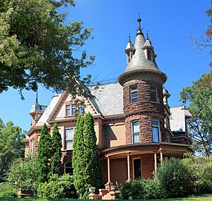
Henderson Castle
Distance: Approx. 880 meters
Latitude and longitude: 42.29286667,-85.605
Henderson Castle, built in 1895, is a large privately owned home located on the steep West Main Hill overlooking downtown Kalamazoo, Michigan. The castle has been recently renovated and is under new ownership. The building is open to the public.
Northglade Montessori Magnet School
Magnet school in Kalamazoo, Michigan, United States
Distance: Approx. 1559 meters
Latitude and longitude: 42.31,-85.59388889
Northglade Montessori Magnet School is a public elementary magnet school for students grades K-5, operated by the Kalamazoo Public Schools, located in Kalamazoo, Michigan, United States. It was established in August 2001 by the restructuring of Northglade Elementary School. The school serves around 250 children, of whom 83% are black and 13% white.
WKPR
Radio station in Kalamazoo, Michigan
Distance: Approx. 1610 meters
Latitude and longitude: 42.31305556,-85.6175
WKPR (1440 AM) was a radio station that served the Kalamazoo, Michigan, area of the United States. WKPR Kalamazoo began its broadcast life in 1960. An unusual result of the Federal Communications Commission (FCC) hearing ahead of its creation was that two radio station licenses were granted at the same time: WKPR (1420 kHz), Kalamazoo, and WDOW (1440 kHz), a new service to Dowagiac.

Charles E. Stuart House
United States historic place
Distance: Approx. 991 meters
Latitude and longitude: 42.29527778,-85.59805556
The Charles E. Stuart House is a single-family home located at 427 Stuart Avenue in Kalamazoo, Michigan. It was listed on the National Register of Historic Places in 1972.

Alonzo T. Prentice House
United States historic place
Distance: Approx. 1692 meters
Latitude and longitude: 42.28861111,-85.595
The Alonzo T. Prentice House is a single-family home located at 839 West Lovell Street in Kalamazoo, Michigan. It was listed on the National Register of Historic Places in 1983.

Enoch Shaffer House
United States historic place
Distance: Approx. 725 meters
Latitude and longitude: 42.30611111,-85.60333333
The Enoch Shaffer House is a single-family home located at 1437 Douglas Avenue in Kalamazoo, Michigan. It is one of only a few Late Victorian farmhouses in Kalamazoo, and is notable for its fine detailing. It was listed on the National Register of Historic Places in 1983.

Stuart Area Historic District
United States historic place
Distance: Approx. 1031 meters
Latitude and longitude: 42.29444444,-85.59833333
The Stuart Area Historic District is a primarily residential historic district in Kalamazoo, Michigan, roughly bounded by the Michigan Central Railroad, Douglas, Forbes, West Main, North, and Elm Streets, and Kalamazoo and Grand Avenues. The bulk of the district was listed on the National Register of Historic Places in 1983, with additions in 1995.

Henderson Park-West Main Hill Historic District
United States historic place
Distance: Approx. 1027 meters
Latitude and longitude: 42.29138889,-85.60583333
The Henderson Park-West Main Hill Historic District is a primarily residential historic district roughly bounded by West Main, Thompson, Academy, Monroe, West Lovell and Valley Streets and Prairie Avenue in Kalamazoo, Michigan. The district was listed on the National Register of Historic Places in 1995.
Weather in this IP's area
overcast clouds
-10 Celsius
-16 Celsius
-10 Celsius
-10 Celsius
1021 hPa
79 %
1021 hPa
986 hPa
10000 meters
3.52 m/s
5.05 m/s
4 degree
100 %