Country:
Region:
City:
Latitude and Longitude:
Time Zone:
Postal Code:
IP information under different IP Channel
ip-api
Country
Region
City
ASN
Time Zone
ISP
Blacklist
Proxy
Latitude
Longitude
Postal
Route
Luminati
Country
Region
va
City
clarksville
ASN
Time Zone
America/New_York
ISP
GCRONLINE
Latitude
Longitude
Postal
IPinfo
Country
Region
City
ASN
Time Zone
ISP
Blacklist
Proxy
Latitude
Longitude
Postal
Route
db-ip
Country
Region
City
ASN
Time Zone
ISP
Blacklist
Proxy
Latitude
Longitude
Postal
Route
ipdata
Country
Region
City
ASN
Time Zone
ISP
Blacklist
Proxy
Latitude
Longitude
Postal
Route
Popular places and events near this IP address

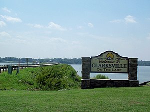
Clarksville, Virginia
Town in Virginia, United States
Distance: Approx. 942 meters
Latitude and longitude: 36.62222222,-78.56222222
Clarksville is a town in Mecklenburg county in the U.S. state of Virginia, near the southern border of the commonwealth. The population was 1,139 at the 2010 census. Since the town has numerous buildings of the 18th-, 19th-, and early 20th-century architecture, the downtown area of Clarksville has been designated a Historic District on the National Register of Historic Places and Virginia's Historic Register.
Dan River
River in the U.S. states of North Carolina and Virginia
Distance: Approx. 5537 meters
Latitude and longitude: 36.65611111,-78.59861111
The Dan River flows 214 miles (344 km) in the U.S. states of North Carolina and Virginia. It rises in Patrick County, Virginia, and crosses the state border into Stokes County, North Carolina. It then flows into Rockingham County.

Prestwould
Historic house in Virginia, United States
Distance: Approx. 3121 meters
Latitude and longitude: 36.64972222,-78.56416667
Prestwould is a historic house near Clarksville, Virginia. It is the most intact and best documented plantation surviving in Southside Virginia. The house was built by Sir Peyton Skipwith, 7th Baronet Skipwith, who moved his family from his Elm Hill Plantation to Prestwould in 1797.

Occoneechee State Park
State park in Virginia, USA
Distance: Approx. 2492 meters
Latitude and longitude: 36.62610083,-78.524101
Occoneechee State Park is a state park near Clarksville, Virginia, located along Buggs Island Lake. Occoneechee State Park is 2,698 acres in size. Its name reflects the Occaneechi Indians, who lived on (and traded from) an island in the Roanoke River near its confluence with the Dan River, which was flooded by the creation of the Kerr Lake reservoir in 1952.

Clarksville Historic District (Clarksville, Virginia)
Historic district in Virginia, United States
Distance: Approx. 570 meters
Latitude and longitude: 36.6225,-78.55805556
The Clarksville Historic District is a national historic district located at Clarksville, Mecklenburg County, Virginia. It encompasses 171 contributing buildings, 2 contributing sites, and 1 contributing structure in the central business district and surrounding residential areas of the town of Clarksille. Notable buildings include the Planters Bank (1909), Planters Brick Tobacco Sales Warehouse (c.

Skipwith, Virginia
Unincorporated community in Virginia, United States
Distance: Approx. 9592 meters
Latitude and longitude: 36.69444444,-78.49083333
Skipwith is an unincorporated community in old Bluestone Township, Mecklenburg County, Virginia, United States. It is located between Chase City and Clarksville, west-northwest of the county seat at Boydton. The community was named for local members of the Skipwith family, related to colonial Virginia Skipwith families which began arriving from English baronial estates in the 1650s.
Buffalo Junction, Virginia
Unincorporated community in Virginia, United States
Distance: Approx. 7445 meters
Latitude and longitude: 36.60444444,-78.63166667
Buffalo Junction is an unincorporated community in Mecklenburg County, Virginia, United States. Buffalo Junction is located on Virginia State Route 49 4.4 miles (7.1 km) west-southwest of Clarksville. Buffalo Junction has a post office with ZIP code 24529.

Clark Royster House
Historic house in Virginia, United States
Distance: Approx. 696 meters
Latitude and longitude: 36.62722222,-78.55805556
The Clark Royster House is a historic home located at Clarksville, Mecklenburg County, Virginia. It was built about 1840, and is a two-story, single-pile Federal style brick dwelling. Also on the property are the contributing site of a combined kitchen and slave quarters and an original 65-foot-deep rock well.

Judge Henry Wood Jr. House
Historic house in Virginia, United States
Distance: Approx. 721 meters
Latitude and longitude: 36.62472222,-78.55972222
The Judge Henry Wood Jr. House is a historic home located at Clarksville, Mecklenburg County, Virginia. It is a two-story, Queen Anne style brick dwelling built in three sections.

Sunnyside (Clarksville, Virginia)
Historic house in Virginia, United States
Distance: Approx. 2081 meters
Latitude and longitude: 36.61305556,-78.57111111
Sunnyside is a historic plantation house located at Clarksville, Mecklenburg County, Virginia. The house was built in three sections: a one-room, two-story, three-bay frame dwelling with a side passage, built in 1833; a two-story, three bay I-house, begun in 1836 in front of the first dwelling and connected to it by a one-story hyphen; and a two-story, one room, one-bay addition built in 1837. Also on the property are the contributing late-19th century kitchen, an early-to-mid-19th century servant's quarter, an early-to-mid-19th century smokehouse, a mid-19th century shed, an early-20th century chicken house, the site of a 19th-century ice pit, a 19th and early 20th century tenant house / tobacco processing barn, three late 19th or early-20th century log tobacco barns, a 19th-century log tenant house, and the Carrington / Johnson family cemetery.

Cedar Grove (Clarksville, Virginia)
Historic house in Virginia, United States
Distance: Approx. 6086 meters
Latitude and longitude: 36.57694444,-78.5875
Cedar Grove is a historic plantation house and farm located near Clarksville, Mecklenburg County, Virginia. The house was built in 1838, and is a Greek Revival style brick dwelling. It consists of a large one-story block on a raised basement with a hipped roof capped with a smaller clerestory with a hipped roof and modern flanking one-story brick wings the historic central block.
Lake Country Regional Airport
Airport in the U.S. state of Virginia
Distance: Approx. 3202 meters
Latitude and longitude: 36.59555556,-78.56027778
Lake Country Regional Airport (FAA LID: W63) is a regional/general aviation airport in Clarksville, Virginia, United States.
Weather in this IP's area
clear sky
9 Celsius
9 Celsius
8 Celsius
11 Celsius
1014 hPa
100 %
1014 hPa
1003 hPa
3219 meters
06:56:45
17:03:01
