65.23.71.12 - IP Lookup: Free IP Address Lookup, Postal Code Lookup, IP Location Lookup, IP ASN, Public IP
Country:
Region:
City:
Location:
Time Zone:
Postal Code:
IP information under different IP Channel
ip-api
Country
Region
City
ASN
Time Zone
ISP
Blacklist
Proxy
Latitude
Longitude
Postal
Route
Luminati
Country
Region
mi
City
grandrapids
ASN
Time Zone
America/Detroit
ISP
US-SIGNAL
Latitude
Longitude
Postal
IPinfo
Country
Region
City
ASN
Time Zone
ISP
Blacklist
Proxy
Latitude
Longitude
Postal
Route
IP2Location
65.23.71.12Country
Region
michigan
City
arcadia
Time Zone
America/Detroit
ISP
Language
User-Agent
Latitude
Longitude
Postal
db-ip
Country
Region
City
ASN
Time Zone
ISP
Blacklist
Proxy
Latitude
Longitude
Postal
Route
ipdata
Country
Region
City
ASN
Time Zone
ISP
Blacklist
Proxy
Latitude
Longitude
Postal
Route
Popular places and events near this IP address

Blaine Township, Michigan
Civil township in Michigan, United States
Distance: Approx. 9157 meters
Latitude and longitude: 44.5625,-86.19361111
Blaine Township is a civil township of Benzie County in the U.S. state of Michigan. As of the 2020 census, the township population was 484. It is located in the southwest portion of the county.

Bear Lake, Michigan
Village in Michigan, United States
Distance: Approx. 8987 meters
Latitude and longitude: 44.42027778,-86.14527778
Bear Lake is a village in Manistee County in the U.S. state of Michigan. The population was 342 at the 2020 census. The village is located within Bear Lake Township.
Pleasanton Township, Michigan
Township in Michigan, United States
Distance: Approx. 7148 meters
Latitude and longitude: 44.46694444,-86.13055556
Pleasanton Township is a civil township of Manistee County in the U.S. state of Michigan. The population was 870 at the 2020 census.
Arcadia, Michigan
Census-designated place in Michigan, United States
Distance: Approx. 1633 meters
Latitude and longitude: 44.49305556,-86.23166667
Arcadia is an unincorporated community and census-designated place (CDP) in Arcadia Township, Manistee County, Michigan, United States. Its population was 309 as of the 2020 census. But in the 2024 census it was 125.

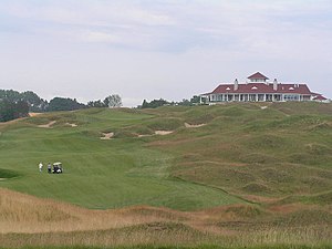
Arcadia Bluffs Golf Course
Distance: Approx. 3474 meters
Latitude and longitude: 44.45638889,-86.24277778
Arcadia Bluffs Golf Club, designed by Warren Henderson and Rick Smith, was founded in 1999 in Arcadia, Michigan. The course is built on the bluffs above the shore of Lake Michigan on approximately 245 acres (99 ha). The course drops 225 feet (69 m) from its highest point down to the bluff, 180 feet (55 m) above lake level and has 3,100 feet (940 m) of lake frontage.

Watervale, Michigan
United States historic place
Distance: Approx. 7992 meters
Latitude and longitude: 44.55388889,-86.21777778
The Watervale Historic District is a resort, originally constructed as a lumber camp, located at 975-1422 Watervale Road on the shore of Lower Herring Lake in Blaine Township, Michigan. It was designated a Michigan State Historic Site in 1991 and listed on the National Register of Historic Places in 2003.

Camp Arcadia
United States historic place
Distance: Approx. 2381 meters
Latitude and longitude: 44.495936,-86.240869
Camp Arcadia is a Lutheran camp, owned and operated by the Lutheran Camp Association. Located on the shores of Lake Michigan in the small town of Arcadia, Michigan, Camp Arcadia has been in continuous operation since its opening in 1922.
Arcadia Township, Manistee County, Michigan
Township in Michigan, United States
Distance: Approx. 548 meters
Latitude and longitude: 44.48638889,-86.22138889
Arcadia Township is a civil township of Manistee County in the U.S. state of Michigan. As of the 2020 census, the township population was 657.
Arcadia Lake (Michigan)
Lake in Manistee County, Michigan, United States
Distance: Approx. 1226 meters
Latitude and longitude: 44.48333333,-86.23333333
Arcadia Lake is a lake in Manistee County, Michigan. The lake, formerly called Bar Lake, is separated from Lake Michigan by a sand bar. A 1,100-foot (340 m) dredged channel connects the two lakes.

Old Facefull
Spring location in the US state of Michigan
Distance: Approx. 6552 meters
Latitude and longitude: 44.427,-86.247
Old Facefull is an artesian spring located in the town of Pierport, Michigan, near the Lake Michigan shoreline. People have used the spring since at least 1931. In addition to the spring's practical uses, people have used this spot to refill fresh water while traveling.
Weather in this IP's area
broken clouds
-1 Celsius
-5 Celsius
-2 Celsius
-1 Celsius
1027 hPa
86 %
1027 hPa
1004 hPa
10000 meters
3.48 m/s
4.64 m/s
143 degree
63 %